File:Fires in Tasmania (MODIS 2021-05-02).jpg

Original file (1,525 × 1,241 pixels, file size: 222 KB, MIME type: image/jpeg)
Captions
Captions
Summary
[edit].jpg&action=edit§ion=1)
| Description |
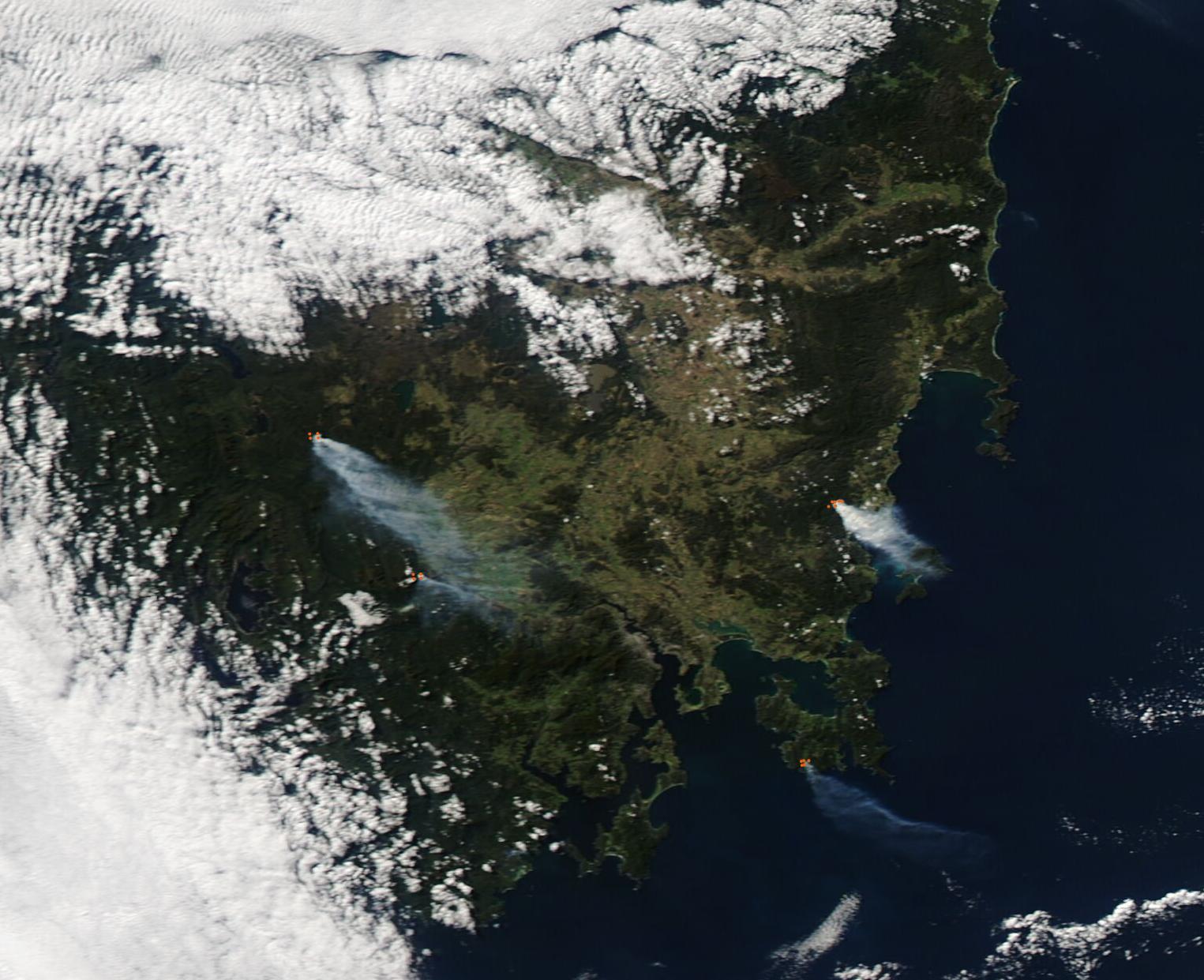
English: Several fires were billowing large plumes of gray smoke across Tasmania on April 30, 2021 when the Moderate Resolution Imaging Spectroradiometer (MODIS) on board NASA’s Aqua satellite acquired this true-color image of the island. Each red “hot spot” marks area where the thermal bands on the instrument detected high temperatures. When combined with typical smoke, as in this image, such hot spots are diagnostic for actively burning fire.
With the Tasmania Fire Service reporting low-to-moderate fire risk in all sections of Tasmania on May 1 (the day after these fires were spotted), it is unlikely that the multiple fires were wildfires. While it is not possible to determine the cause of a fire from satellite imagery, given the time of year, location, and low fire risk, these fires are almost certainly prescribed burns—fires that are deliberately set and controlled with the goal of managing land. The Tasmanian Fire Service has issued announcements of multiple and near-daily fuel reduction burns across the state. Fuel reduction burns are a type of prescribed burn. One notable burn is a fuel reduction burn performed by the Tasmanian Parks and Wildlife Service at Needwonnee Walk, Melaleuca, South West National Park. The announcement read, “This burn is part of the TWWHA Fire Mitigation Program which is aimed at reducing fire risk to visitors, communities, the outstanding universal value of the TWWHA, critical infrastructure within and adjacent to the TWWHA. This burn is also a priority to renew foraging habitat for the Critically Endangered Orange-bellied Parrot.” TWWHA is the acronym for the Tasmanian Wilderness World Heritage Area, one of Tasmania’s most iconic places. Inscribed on the UNESCO World Heritage List in1982, the TWWHA covers one and a half million hectares, or around one-fifth of Tasmania’s land mass, and contains globally significant natural and cultural heritage areas. |
||
| Date | Taken on 30 April 2021 | ||
| Source |
Fires in Tasmania (direct link)
|
||
| Author | MODIS Land Rapid Response Team, NASA GSFC |
| This media is a product of the Aqua mission Credit and attribution belongs to the mission team, if not already specified in the "author" row |
Licensing
[edit].jpg&action=edit§ion=2)
| This file is in the public domain in the United States because it was solely created by NASA. NASA copyright policy states that "NASA material is not protected by copyright unless noted". (See Template:PD-USGov, NASA copyright policy page or JPL Image Use Policy.) | ||
 |
Warnings:
|
File history
Click on a date/time to view the file as it appeared at that time.
| Date/Time | Thumbnail | Dimensions | User | Comment | |
|---|---|---|---|---|---|
| current | 17:50, 30 January 2024 | | 1,525 × 1,241 (222 KB) | OptimusPrimeBot (talk | contribs) | #Spacemedia - Upload of http://modis.gsfc.nasa.gov/gallery/images/image05022021_250m.jpg via Commons:Spacemedia |
You cannot overwrite this file.
File usage on Commons
There are no pages that use this file.
.jpg&oldid=847255460)