File:Fleurieu Peninsula, South Australia – satellite map.tif
Jump to navigation
Jump to search

Size of this PNG preview of this TIF file: 605 × 599 pixels. Other resolutions: 242 × 240 pixels | 485 × 480 pixels | 776 × 768 pixels | 1,034 × 1,024 pixels | 1,518 × 1,503 pixels.
Original file (1,518 × 1,503 pixels, file size: 8.71 MB, MIME type: image/tiff)
Captions
Captions
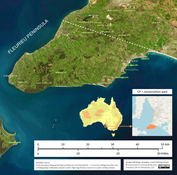
A satellite map of Fleurieu Peninsula, South Australia
Summary
[edit]| Description |
English: A satellite map of Fleurieu Peninsula, South Australia |
| Date | |
| Source |
Map: Location SA MapViewer (http://location.sa.gov.au/viewer/) Artwork: own work |
| Author | Government of South Australia |
| Camera location | | View this and other nearby images on: OpenStreetMap |
|---|
Licensing
[edit]This file is licensed under the Creative Commons Attribution 4.0 International license.
Attribution: Government of South Australia.
The Government of South Australia owns copyright in this work, which it has licensed in keeping with the Open Data Policy initiated by the Australian Government. The Policy includes the direction: "all government agencies should make non-sensitive data open by default, and it should be free, easy to use, and reliable. Agencies should publish anonymised data ... under a Creative Commons BY Attribution licence."
The Government of South Australia owns copyright in this work, which it has licensed in keeping with the Open Data Policy initiated by the Australian Government. The Policy includes the direction: "all government agencies should make non-sensitive data open by default, and it should be free, easy to use, and reliable. Agencies should publish anonymised data ... under a Creative Commons BY Attribution licence."
- You are free:
- to share – to copy, distribute and transmit the work
- to remix – to adapt the work
- Under the following conditions:
- attribution – You must give appropriate credit, provide a link to the license, and indicate if changes were made. You may do so in any reasonable manner, but not in any way that suggests the licensor endorses you or your use.
File history
Click on a date/time to view the file as it appeared at that time.
| Date/Time | Thumbnail | Dimensions | User | Comment | |
|---|---|---|---|---|---|
| current | 05:10, 27 January 2021 |  | 1,518 × 1,503 (8.71 MB) | SCHolar44 (talk | contribs) | Uploaded a work by Government of South Australia from Map: Location SA MapViewer (http://location.sa.gov.au/viewer/) Artwork: own work with UploadWizard |
You cannot overwrite this file.
File usage on Commons
There are no pages that use this file.
File usage on other wikis
The following other wikis use this file:
- Usage on en.wikipedia.org
- Usage on et.wikipedia.org
- Usage on id.wikipedia.org
- Usage on pl.wikipedia.org
- Usage on tr.wikipedia.org