File:Flinders Ranges, South Australia ESA22155769.tiff

Original file (8,118 × 6,150 pixels, file size: 285.7 MB, MIME type: image/tiff)
Captions
Captions
Summary[edit]
| Description |
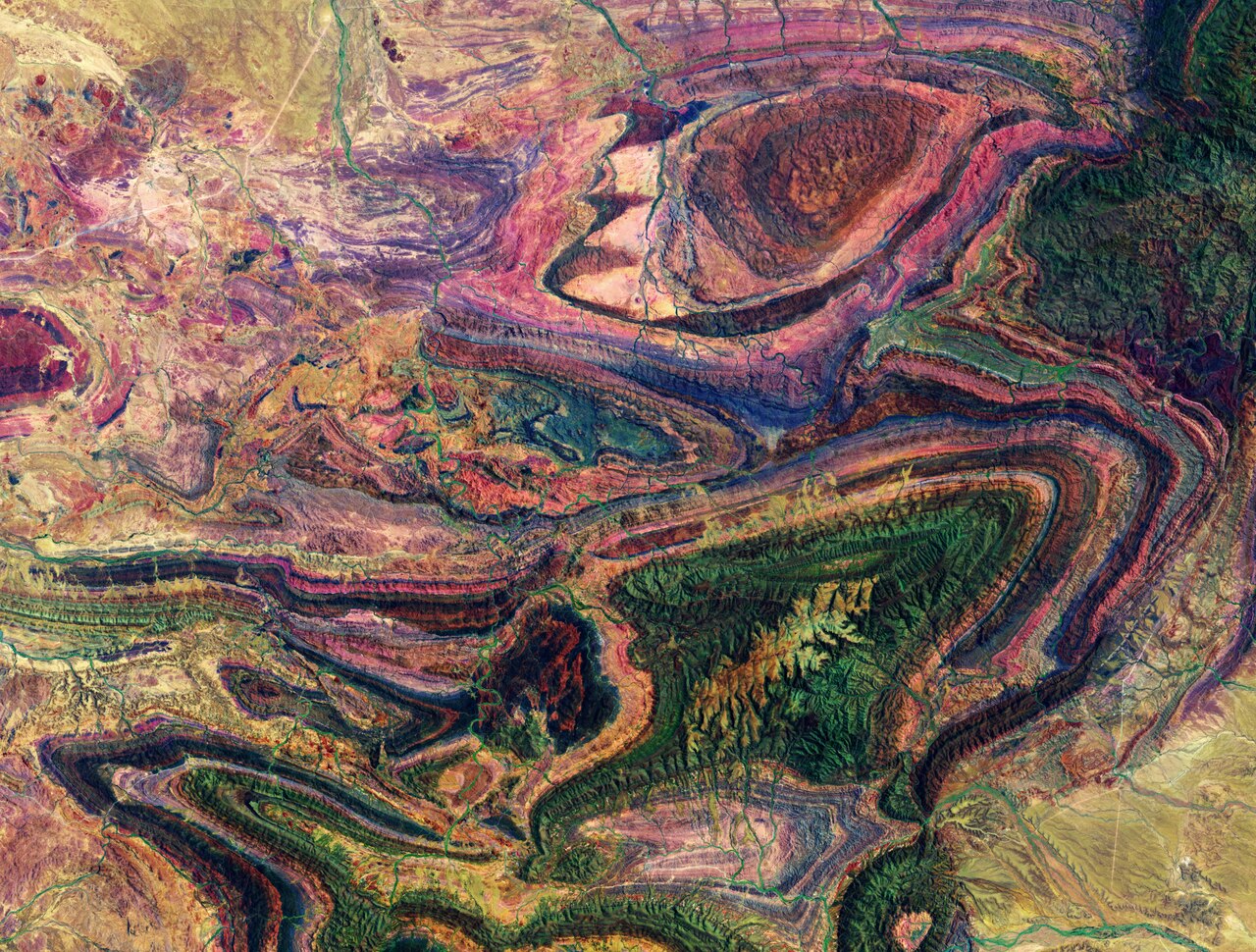
English: The many colourful curves and folds of the Flinders Ranges – the largest mountain range in South Australia – are featured in this false-colour image captured by the Copernicus Sentinel-2 mission. The Flinders mountains are a classic example of a folded mountain range, which are formed when two or more of Earth’s tectonic plates collide – folding and pushing layers of land into mountain ranges. The formation of the Flinders Range began to form around 800 million years ago, when an ancient sea deposited sediments into the Adelaide Geosyncline basin. Millions of years later, the sediments were folded into mountains, which have since eroded. However, the folded rocks remained and were uplifted to create the landscape as we see it today. The Flinders Ranges stretches for over 400 km across the Australian outback – from Port Pirie to Lake Callabonna. The first humans to inhabit the Flinders Ranges were the Adnyamathanha people, who have inhabited the range for tens of thousands of years. The area pictured here shows the Vulkathunha-Gammon Ranges National Park in the Northern Flinders Ranges. The rugged park’s main attractions include deep gorges, chasms and an impressive wilderness. Numerous creeks appear like veins across the entire image, while the straight, white lines visible in the bottom right are dirt roads. Slightly west of the image pictured here lies the Ediacara Hills, where some of the oldest fossil evidence of animal life was discovered. The flora of the Flinders Ranges are largely species who have adapted to a semi-arid environment, including sugar gum tree, cypress-pine and mallee. Since the eradication of dingoes in the area, the number of red kangaroos, western grey kangaroos and wallaroos in the mountains has increased. This image, also featured on the Earth from Space video programme, was captured on 31 December 2019 by the Copernicus Sentinel-2 mission – a two-satellite mission to supply the coverage and data delivery needed for Europe’s Copernicus programme. The image was processed by selecting spectral bands that can be used for classifying geological features. |
| Date | Taken on 31 December 2019 |
| Source | Flinders Ranges, South Australia |
| Author | European Space Agency |
| Other versions |
|
| Activity | Observing the Earth |
| Mission | Sentinel-2 |
| Set | Earth observation image of the week |
| System | Copernicus |

Licensing[edit]

|
This image contains data from a satellite in the Copernicus Programme, such as Sentinel-1, Sentinel-2 or Sentinel-3. Attribution is required when using this image.
Attribution: Contains modified Copernicus Sentinel data 2019
The use of Copernicus Sentinel Data is regulated under EU law (Commission Delegated Regulation (EU) No 1159/2013 and Regulation (EU) No 377/2014). Relevant excerpts:
Free access shall be given to GMES dedicated data [...] made available through GMES dissemination platforms [...].
Access to GMES dedicated data [...] shall be given for the purpose of the following use in so far as it is lawful:
GMES dedicated data [...] may be used worldwide without limitations in time.
GMES dedicated data and GMES service information are provided to users without any express or implied warranty, including as regards quality and suitability for any purpose. |
This media was created by the European Space Agency (ESA).
Where expressly so stated, images or videos are covered by the Creative Commons Attribution-ShareAlike 3.0 IGO (CC BY-SA 3.0 IGO) licence, ESA being an Intergovernmental Organisation (IGO), as defined by the CC BY-SA 3.0 IGO licence. The user is allowed under the terms and conditions of the CC BY-SA 3.0 IGO license to Reproduce, Distribute and Publicly Perform the ESA images and videos released under CC BY-SA 3.0 IGO licence and the Adaptations thereof, without further explicit permission being necessary, for as long as the user complies with the conditions and restrictions set forth in the CC BY-SA 3.0 IGO licence, these including that:
See the ESA Creative Commons copyright notice for complete information, and this article for additional details.
|
 | |
This file is licensed under the Creative Commons Attribution-ShareAlike 3.0 IGO license. Attribution: ESA, CC BY-SA IGO 3.0
| ||
File history
Click on a date/time to view the file as it appeared at that time.
| Date/Time | Thumbnail | Dimensions | User | Comment | |
|---|---|---|---|---|---|
| current | 12:17, 1 August 2020 |  | 8,118 × 6,150 (285.7 MB) | OptimusPrimeBot (talk | contribs) | #Spacemedia - Upload of https://esamultimedia.esa.int/img/2020/07/Hawks_eye_Sentinel-2_31December2019_120802_IOW_ML.tif via Commons:Spacemedia |
You cannot overwrite this file.
File usage on Commons
The following page uses this file: