File:Flooding in Northwest Australia (MODIS).jpg

Original file (1,762 × 1,425 pixels, file size: 486 KB, MIME type: image/jpeg)
Captions
Captions
Summary
[edit].jpg&action=edit§ion=1)
| Description |
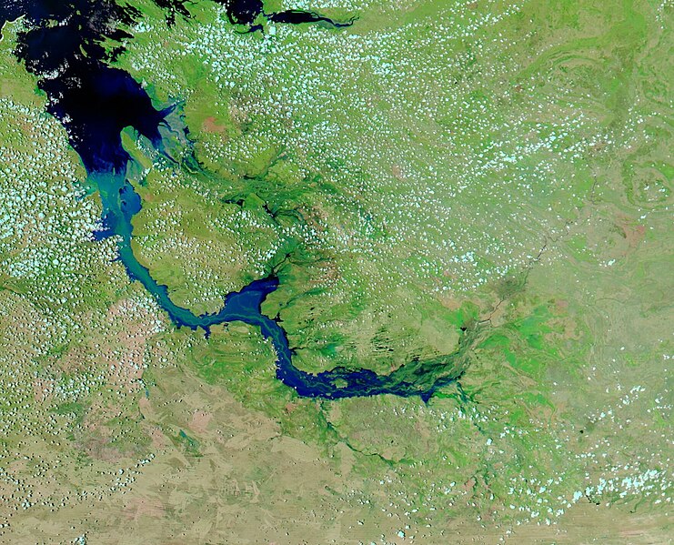
English: Starting on December 30, 2022, remnants of Tropical Cyclone Ellie brought days of torrential rain and wind to northern Western Australia. The deluge caused the Fitzroy River to swell to record-high levels, inundating floodplains and isolating several riverside communities.
Severe flooding is evident in the false-color image acquired on January 9, 2023, by the Moderate Resolution Imaging Spectroradiometer (MODIS) on NASA’s Aqua satellite. Water appears light to dark blue; vegetation is green and bare land is brown. NASA’s Worldview App permits an easy comparison between today’s image and one acquired by Aqua MODIS on December 17, 2022. To see the stark difference in the same area pre- and post-flood, simply click here Flooding is common along rivers of the Kimberly region in Western Australia. But the amount of water delivered by the ex-tropical cyclone was exceptional. From December 30, 2022, through the first week of January 2023, rainfall totals across the region ranged from 200 to 500 millimeters (7.9 to 19.7 inches). As a result, the Fitzroy River’s flow rate reached about 60,000 cubic meters per second—well above the 23,000 cubic meters per second usually seen during floods on this river, and one of the highest flow rates ever observed in any Australian river. Australia’s Bureau of Meteorology reported that the river’s water levels near the town of Fitzroy Crossing peaked at a record-high 15.81 meters on January 4. That’s almost two meters higher than the previous record reached during flooding in 2002.The floodwater left many roads and bridges impassable, isolating Fitzroy Crossing, Derby, Broome, and many of the region’s remote indigenous communities. Tropical Cyclone Ellie first hit Australia’s Northern Territory as a Category 1 storm on December 23, 2022. It then weakened into a tropical low before moving into Western Australia on December 30. By January 7, 2023, the former tropical cyclone had moved back into the Northern Territory and further weakened as it moved toward Queensland. The recent flooding in Western Australia follows several severe flooding events that have occurred in eastern Australia during three consecutive years of La Niña conditions. La Niña usually brings wetter-than-average conditions to the country. 2022 was Australia’s ninth-wettest year on record. |
||
| Date | Taken on 9 January 2023 | ||
| Source |
Flooding in Northwest Australia (direct link)
|
||
| Author | MODIS Land Rapid Response Team, NASA GSFC |
| This media is a product of the Aqua mission Credit and attribution belongs to the mission team, if not already specified in the "author" row |
Licensing
[edit].jpg&action=edit§ion=2)
| This file is in the public domain in the United States because it was solely created by NASA. NASA copyright policy states that "NASA material is not protected by copyright unless noted". (See Template:PD-USGov, NASA copyright policy page or JPL Image Use Policy.) | ||
 |
Warnings:
|
File history
Click on a date/time to view the file as it appeared at that time.
| Date/Time | Thumbnail | Dimensions | User | Comment | |
|---|---|---|---|---|---|
| current | 20:07, 31 July 2023 | | 1,762 × 1,425 (486 KB) | OptimusPrimeBot (talk | contribs) | #Spacemedia - Upload of http://modis.gsfc.nasa.gov/gallery/images/image01102023_250m.jpg via Commons:Spacemedia |
You cannot overwrite this file.
File usage on Commons
There are no pages that use this file.
.jpg&oldid=792463394)