File:Flooding in Queensland (MODIS 2019-04-08).jpg

Original file (4,595 × 3,619 pixels, file size: 1.82 MB, MIME type: image/jpeg)
Captions
Captions
Summary[edit]
.jpg&action=edit§ion=1)
| Description |
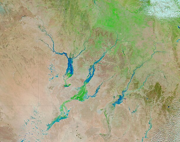
English: In February 2019, a series of powerful, slow-moving storm systems dropped record-breaking rains on northern Queensland. Some areas received more than 1000 millimeters (40 inches) over a seven-day period, according to Australia’s Bureau of Meteorology.
Much of this water drained quickly into the sea, but some of it fell within the low-lying Lake Eyre Basin. As water flowed south toward Lake Eyre (also called Kati Thanda) in South Australia—the lowest point on the continent—it filled wide, braided river channels that are normally parched, barren, and brown. By March, an ephemeral carpet of green—mainly sedges, reeds, and grasses—had emerged in the river channels and floodplain as flood water receded. In late March, Queensland faced a second deluge. This time Cyclone Trevor slammed the coast of northwestern Queensland on March 23, 2019, and continued to produce heavy rains as it moved inland. When the Moderate Resolution Imaging Spectroradiometer (MODIS) on board NASA’s Aqua satellite acquired this false-color image of the region on April 3, 2019, another big pulse of flood water was flowing south through several rivers in the Lake Eyre Basin. The false-color image uses a combination of visible and infrared light to make it easier to distinguish between land, water, and vegetation. With this band combination, water appears light blue and vegetation is green. The three flooded rivers are, from the northwest to southeast, the Georgina, the Diamantina, and the Copper Rivers. Lake Eyre itself sits in the southwest, off the lower left corner of the image. The green area on the Diamantina and Georgina rivers emerged after the first round of rain, while the water to the north of the green is the pulse of water that came from the remnants of Trevor. While this single image provides an interesting insight into the effect of flooding in the Lake Eyre Basin, viewing a roll-over comparison between this image and one acquired on March 31, 2019, give added insight into the separate pulses of floodwater. On March 31, the areas in the river flood plains that are currently green were filled with water, while the upper reaches of the three rivers appeared to be only slightly wetter than normal. The comparison can be seen HERE |
||
| Date | Taken on 3 April 2019 | ||
| Source |
Flooding in Queensland (direct link)
|
||
| Author | MODIS Land Rapid Response Team, NASA GSFC |
| This media is a product of the Aqua mission Credit and attribution belongs to the mission team, if not already specified in the "author" row |
Licensing[edit]
.jpg&action=edit§ion=2)
| This file is in the public domain in the United States because it was solely created by NASA. NASA copyright policy states that "NASA material is not protected by copyright unless noted". (See Template:PD-USGov, NASA copyright policy page or JPL Image Use Policy.) | ||
 |
Warnings:
|
File history
Click on a date/time to view the file as it appeared at that time.
| Date/Time | Thumbnail | Dimensions | User | Comment | |
|---|---|---|---|---|---|
| current | 03:25, 17 February 2024 | | 4,595 × 3,619 (1.82 MB) | OptimusPrimeBot (talk | contribs) | #Spacemedia - Upload of http://modis.gsfc.nasa.gov/gallery/images/image04082019_250m.jpg via Commons:Spacemedia |
You cannot overwrite this file.
File usage on Commons
There are no pages that use this file.
.jpg&oldid=852743805)