File:Flooding in Southern Brazil (MODIS 2024-05-13).jpg

Original file (4,098 × 3,034 pixels, file size: 1.84 MB, MIME type: image/jpeg)
Captions
Captions
Summary
[edit].jpg&action=edit§ion=1)
| Description |
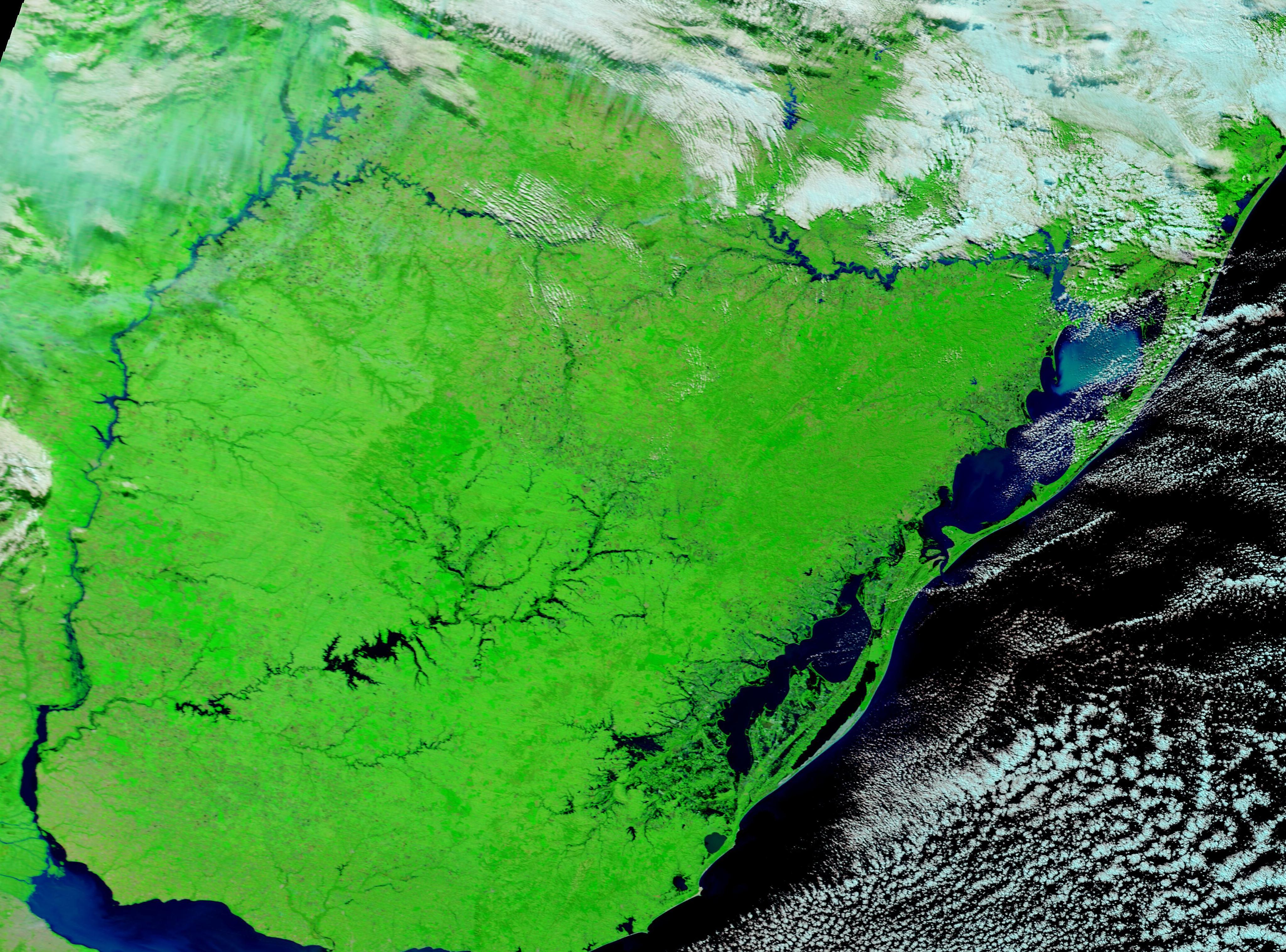
English: May 9, 2024 April 28, 2024
Severe storms and record rainfall triggered widespread flooding in Rio Grande do Sul, a state in southern Brazil in late April and early May 2024. As of May 10, at least 113 people have been confirmed deceased, with 146 more reported missing, according to ReliefWeb. More than 337,999 people have been displaced, with nearly 70,000 in shelters. It has been estimated that nearly 100,000 homes have been destroyed throughout Rio Grande do Sul. In Porto Alegre, where more than five months of rain fell in just one week, about 1 million people are without potable water. Floods have also impacted Uruguay, which is located just south of Rio Grande do Sul, Brazil, and parts of northeastern Argentina. Hundreds of people have been displaced in Argentina along the rising Uruguay River, which forms the border between the two countries. The impact was even greater in Uruguay, where thousands were reported to be displaced. The Moderate Resolution Imaging Spectroradiometer (MODIS) on NASA’s Terra satellite acquired a pair of false-color images that illustrate the severe flooding in Rio Grande do Sul. This type of image helps separate water (blue) from vegetation, which appears vibrant green. The top image was acquired on May 9, 2024, after twelve days of flooding. The large river in the west is the Uruguay River, and the large, flooded lake in the south is Ricon del Bonete Lake in Uruguay. Porto Alegre, Brazil, is located where the swollen Jacui River makes a hard southward turn to flow into the Guaiba River then into the brightly colored Lagos dos Patos. Clicking on the date under the image reveals a second image acquired on April 28, the day after rain began pummeling the region and before any flooding had occurred. Although skies are clear in this image, heavy cloud cover obscured the region just to the north as the storm system continued dumping torrential rain. |
||
| Date | Taken on 9 May 2024 | ||
| Source |
Flooding in Southern Brazil (direct link)
|
||
| Author | MODIS Land Rapid Response Team, NASA GSFC |
| This media is a product of the Terra mission Credit and attribution belongs to the mission team, if not already specified in the "author" row |
Licensing
[edit].jpg&action=edit§ion=2)
| This file is in the public domain in the United States because it was solely created by NASA. NASA copyright policy states that "NASA material is not protected by copyright unless noted". (See Template:PD-USGov, NASA copyright policy page or JPL Image Use Policy.) | ||
 |
Warnings:
|
File history
Click on a date/time to view the file as it appeared at that time.
| Date/Time | Thumbnail | Dimensions | User | Comment | |
|---|---|---|---|---|---|
| current | 05:05, 13 May 2024 | | 4,098 × 3,034 (1.84 MB) | OptimusPrimeBot (talk | contribs) | #Spacemedia - Upload of http://modis.gsfc.nasa.gov/gallery/images/image05132024_250m.jpg via Commons:Spacemedia |
You cannot overwrite this file.
File usage on Commons
There are no pages that use this file.
.jpg&oldid=876121826)