File:Florence 2018-09-12 1507Z.jpg
From Wikimedia Commons, the free media repository
Jump to navigation
Jump to search

Size of this preview: 719 × 599 pixels. Other resolutions: 288 × 240 pixels | 576 × 480 pixels | 922 × 768 pixels | 1,229 × 1,024 pixels | 2,457 × 2,048 pixels | 6,483 × 5,403 pixels.
Original file (6,483 × 5,403 pixels, file size: 8.43 MB, MIME type: image/jpeg)
File information
Structured data
Captions
Captions
Add a one-line explanation of what this file represents
Summary[edit]
| DescriptionFlorence 2018-09-12 1507Z.jpg |
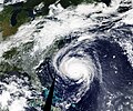
English: The Moderate Resolution Imaging Spectroradiometer (MODIS) on NASA’s Terra satellite acquired this natural-color image of Hurricane Florence just before noon on September 12, 2018.
At 2 p.m. Eastern Daylight Time on September 12, the center of the storm was 435 miles (700 kilometers) southeast of Wilmington, North Carolina. The National Hurricane Center and U.S. Air Force reported sustained winds of 125 miles (205 kilometers) per hour, with a central pressure of 948 millibars. Hurricane and storm surge warnings were in effect from South Santee River, South Carolina, to Duck, North Carolina. Hurricane and surge watches stretched most of the way from the South Carolina-Georgia border to southeastern Virginia. |
| Date | |
| Source | https://earthobservatory.nasa.gov/images/92744/awesome-frightening-views-of-hurricane-florence |
| Author | NASA Earth Observatory |
Licensing[edit]
| Public domainPublic domainfalsefalse |
| This file is in the public domain in the United States because it was solely created by NASA. NASA copyright policy states that "NASA material is not protected by copyright unless noted". (See Template:PD-USGov, NASA copyright policy page or JPL Image Use Policy.) |  | |
 |
Warnings:
|
File history
Click on a date/time to view the file as it appeared at that time.
| Date/Time | Thumbnail | Dimensions | User | Comment | |
|---|---|---|---|---|---|
| current | 09:25, 3 December 2018 |  | 6,483 × 5,403 (8.43 MB) | A1Cafel (talk | contribs) | User created page with UploadWizard |
You cannot overwrite this file.
File usage on Commons
The following 2 pages use this file:
Hidden category: