File:France Pays bretons map.svg
跳转到导航
跳转到搜索

此SVG文件的PNG预览的大小:783 × 599像素。 其他分辨率:314 × 240像素 | 627 × 480像素 | 1,004 × 768像素 | 1,280 × 980像素 | 2,560 × 1,959像素 | 946 × 724像素。
原始文件 (SVG文件,尺寸为946 × 724像素,文件大小:1,017 KB)
说明
说明
添加一行文字以描述该文件所表现的内容
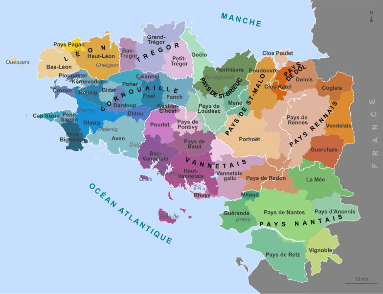
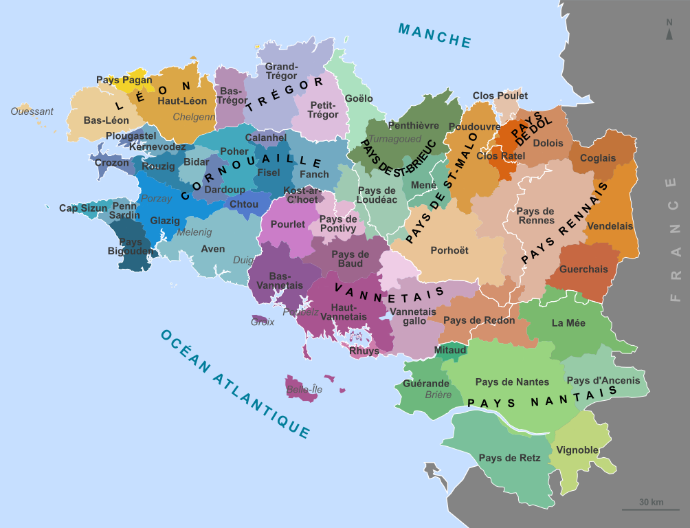
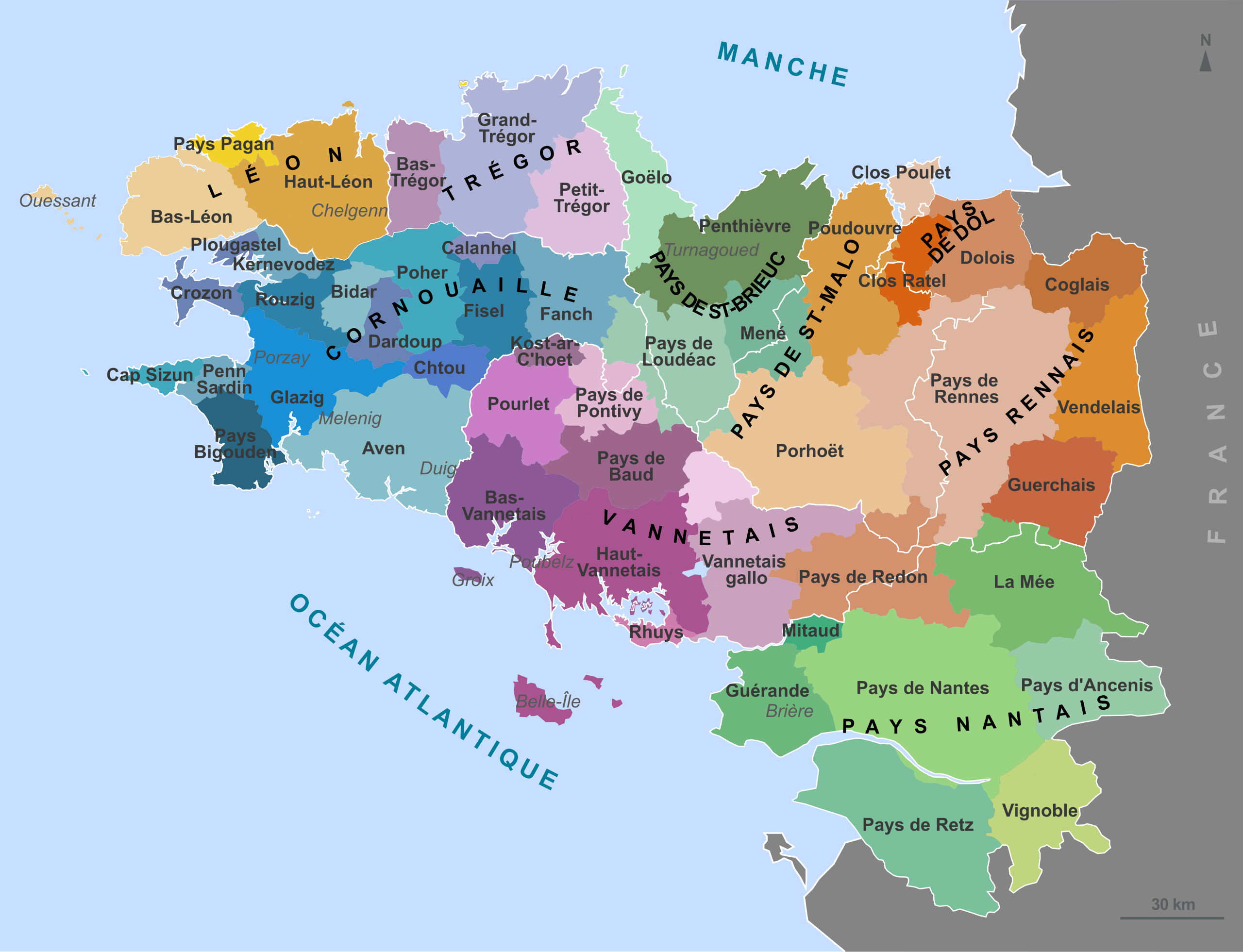
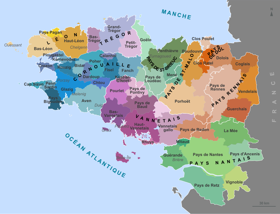
Traditional regions of Brittany
摘要[编辑]
| 描述 |
English: Map of the traditional regions of Brittany (France) Français : Carte des pays traditionnels bretons. Brezhoneg: Kartenn broioù hengounel Breizh (e galleg) |
||
| 日期 | (UTC) | ||
| 来源 | |||
| 作者 |
|
||
| 授权 (二次使用本文件) |
我,本作品著作权人,特此采用以下许可协议发表本作品:
您可以选择您需要的许可协议。 |
||
| 其他版本 |
此文件衍生的作品: Bretagne historic location map.svg
[]
|


|
此SVG檔案包含可翻譯至您的語言的内嵌文字,可以使用任何可用SVG編輯器、文本編輯器或SVG翻譯工具來翻譯。詳情請見:關於翻譯SVG檔案。 |
原始上传日志[编辑]
This image is a derivative work of the following images:
- File:France_Pays_bretons_map.jpg licensed with Cc-by-sa-3.0,2.5,2.0,1.0, GFDL
- 2010-03-31T12:59:09Z Pethrus 1500x1189 (835023 Bytes) {{Information |Description={{en|Map of the traditionnal regions of Bretagne (France)}}{{fr|Carte des pays traditionnels bretons}} |Source=[http://www.geobreizh.com www.geobreizh.com], Mikael Bodlore-Penlaez |Date=2010-03-30 |
Uploaded with derivativeFX
文件历史
点击某个日期/时间查看对应时刻的文件。
| 日期/时间 | 缩略图 | 大小 | 用户 | 备注 | |
|---|---|---|---|---|---|
| 当前 | 2010年4月23日 (五) 08:10 | | 946 × 724(1,017 KB) | Pethrus(留言 | 贡献) | Border fixed. |
| 2010年4月22日 (四) 13:09 |  | 946 × 724(1,017 KB) | Pethrus(留言 | 贡献) | Name fix. | |
| 2010年4月22日 (四) 12:51 |  | 946 × 724(1,017 KB) | Pethrus(留言 | 贡献) | {{Information |Description={{en|Map of the traditionnal regions of Brittany (France)}}{{fr|Carte des pays traditionnels bretons.}} |Source=*File:France_Pays_bretons_map.jpg {{inkscape}} |Date=2010-04-22 12:50 (UTC) |Author=*[[:File:France_Pays_breto |
您不可以覆盖此文件。
文件用途
以下8个页面使用本文件:
全域文件用途
以下其他wiki使用此文件:
- an.wikipedia.org上的用途
- ca.wikipedia.org上的用途
- de.wikipedia.org上的用途
- el.wikipedia.org上的用途
- en.wikipedia.org上的用途
- eo.wikipedia.org上的用途
- es.wikipedia.org上的用途
- fr.wikipedia.org上的用途
- Duché de Bretagne
- Drapeau de la Bretagne
- Pays Bigouden
- Porhoët
- Pays de Retz
- Pays de la Mée
- Saint-Nicolas-du-Pélem
- Haute-Bretagne
- Penthièvre
- Goëlo
- Pays de Bretagne
- Kost ar c'hoad
- Poudouvre
- Pays Pourlet
- Pays Glazik
- Gilles de Rais
- Coglais
- Wikipédia:Atelier graphique/Cartes/Archives/avril 2010
- Presqu'île guérandaise
- Pays Fañch
- Mitau
- Pays du Vignoble nantais
- Pays de Guérande
- Vendelais
- Guerchais
- Portail:Histoire de Bretagne
- Portail:Histoire de Bretagne/Présentation
- Pays Chelgen
- Kost ar c'hoad (pays)
- Pays Fisel
查看本文件的更多全域用途。