File:Francia occidentalis es.svg
Jump to navigation
Jump to search

Size of this PNG preview of this SVG file: 621 × 599 pixels. Other resolutions: 249 × 240 pixels | 497 × 480 pixels | 796 × 768 pixels | 1,061 × 1,024 pixels | 2,122 × 2,048 pixels | 1,091 × 1,053 pixels.
Original file (SVG file, nominally 1,091 × 1,053 pixels, file size: 194 KB)
Captions
Captions
Add a one-line explanation of what this file represents
| Description |
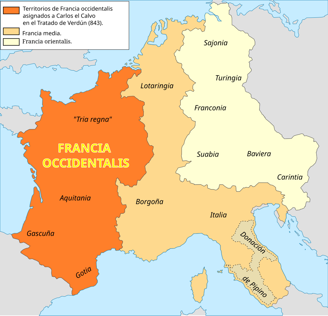
English: Francia occidentalis following the Treaty of Verdun (843)
Español: Francia occidentalis posterior al Tratado de Verdún (843) |
||
| Date | |||
| Source | Own work | ||
| Author | Trasamundo | ||
| Permission (Reusing this file) |
I, the copyright holder of this work, hereby publish it under the following licenses:
This file is licensed under the Creative Commons Attribution-Share Alike 3.0 Unported, 2.5 Generic, 2.0 Generic and 1.0 Generic license.
You may select the license of your choice. |
||
| Other versions |
[]
|


References for Tria regna:
- [1]: Son trisième atout est la fusion des peuples dans les Trois règnes, les Tria regna que ses ancêtres lui ont légués
- [2]: The conquest was integrated into te Frankish kingdom as one of the "three [constituent] kingdoms" (tria regna) that endured to the eight century.
- [3]: A Senlis, les Evêques et les Grands du Tri Regna, la Neustrie, l'Austrase et la Bougogne - la coutume n'admet point à l'acclamatio ceux d'Aquitaine -, écoutent Adalbéron.
- [4]: Dans la future France, il y a certes plusieurs regna, mais la faculté d'élire comme celle d'être élu reste réservé aux Francs ou, pour être plus précis, au vieux noyau franc composé des tria regna, c'est-à-dire la Neustrie, l'Austrasie et la Bourgogne: on les avait tout simplement adaptés à une Francie (occidentale) devenue plus exiguë, formée de Francia entre Seine et Meuse, de la Neustria entre Seine et Loire, et du reste de la Burgundia encore considerée come le royaume de Bourgogne, jamais comme un simple duché.
References for Lotaringia:
- [5]:A Lotario II la Austrasia del lado acá del Rhin, que de su nombre fue llamada Lotaringia
File history
Click on a date/time to view the file as it appeared at that time.
| Date/Time | Thumbnail | Dimensions | User | Comment | |
|---|---|---|---|---|---|
| current | 09:24, 1 September 2016 | | 1,091 × 1,053 (194 KB) | Rowanwindwhistler (talk | contribs) | https://en.wikipedia.org/wiki/Wikipedia:WikiProject_Maps/Conventions http://colorbrewer2.org/#type=sequential&scheme=YlOrBr&n=5 Map was cleaned up and made smaller |
| 18:14, 13 March 2010 |  | 1,091 × 1,053 (919 KB) | Trasamundo (talk | contribs) | Only the limits of the kingdoms established in the Treaty of Verdun. | |
| 15:10, 14 July 2009 |  | 1,091 × 1,040 (1.02 MB) | Trasamundo (talk | contribs) | {{Information |Description={{en|1=Francia media following the Treaty of Verdun (843)}} {{es|1=Francia media posterior al Tratado de Verdún (843)}} |Source=trabajo propio (own work) |Author=Trasamundo |Date=14 July 2009 |Permission={{s |
You cannot overwrite this file.
File usage on Commons
The following 5 pages use this file:
File usage on other wikis
The following other wikis use this file:
- Usage on cs.wikipedia.org
- Usage on es.wikipedia.org
- Usage on nl.wikipedia.org
- Usage on nn.wikipedia.org
- Usage on no.wikipedia.org
- Usage on vls.wikipedia.org