File:Frankish Empire 481 to 814-de.svg
Jump to navigation
Jump to search

Size of this PNG preview of this SVG file: 800 × 566 pixels. Other resolutions: 320 × 226 pixels | 640 × 453 pixels | 1,024 × 724 pixels | 1,280 × 905 pixels | 2,560 × 1,810 pixels | 1,735 × 1,227 pixels.
Original file (SVG file, nominally 1,735 × 1,227 pixels, file size: 332 KB)
Captions
Captions
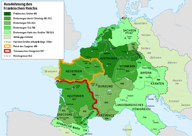
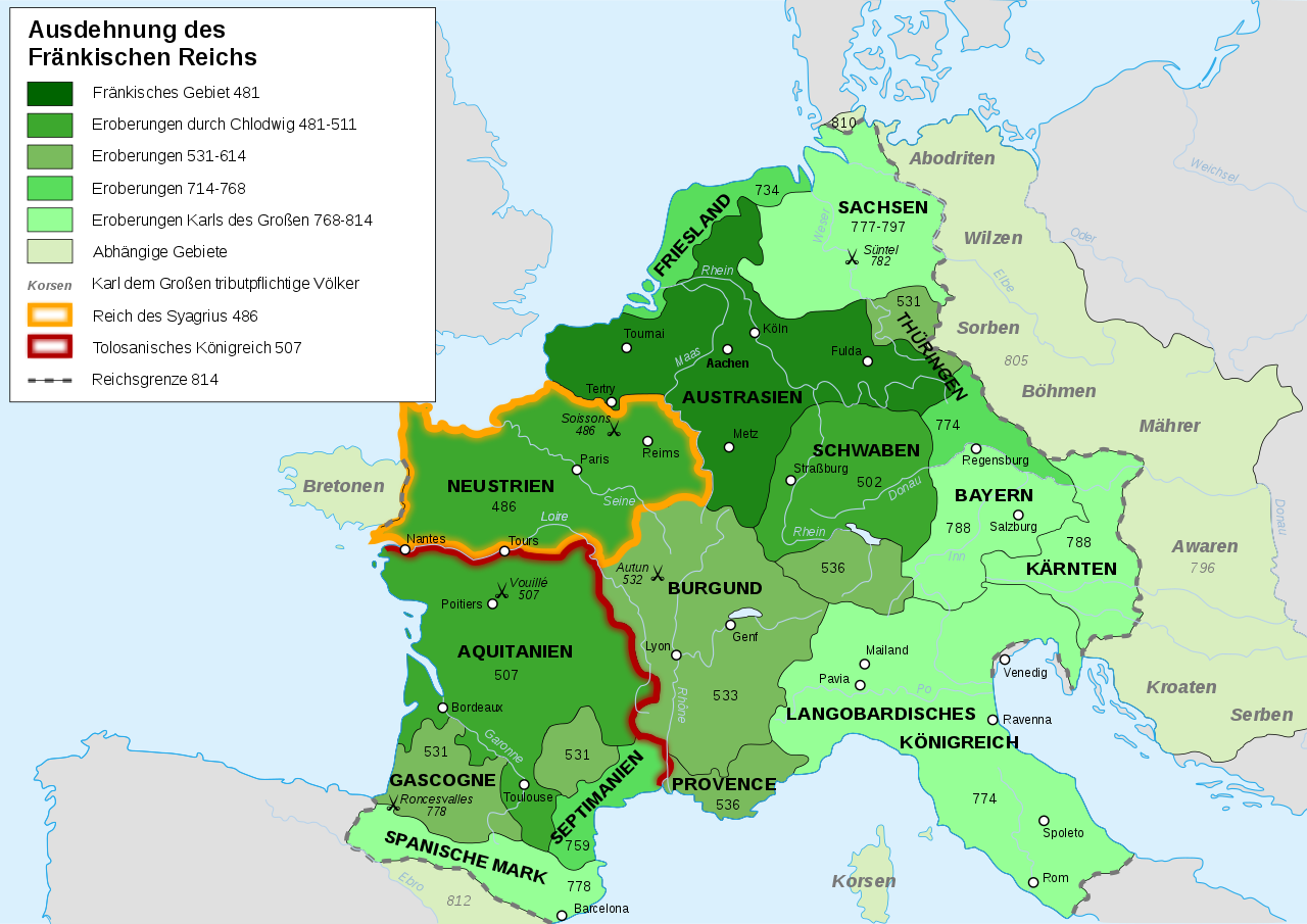
Map of the expansion of the Frankish Empire
Summary[edit]
| Description |
[] Afrikaans: Die veranderende strekking van die Frankiese Ryk van 481 tot 814. Alemannisch: S Frankeriich vo 481 bis 814. Bahasa Indonesia: Peta kebangkitan Kekaisaran Franka, dari tahun 481 hingga 814. Català: Mapa de l'expansió de l'Imperi Franc, de 481 a 814. Deutsch: Karte der Ausdehnung des Fränkischen Reichs 481 bis 814. English: Map of the rise of Frankish Empire, from 481 to 814. Español: Mapa de la expansión del Imperio Franco, entre 481 y 814. Euskara: Frankoen Inperioaren hedapenaren mapa, 481-814 urteen bitartean. Français : Carte de l'expansion de l'empire Franc, entre 481 et 814. Italiano: Carta dell'espansione dell'impero dei Franchi tra il 481 e il 814. Magyar: Frank Birodalom 481-814 Nederlands: Kaart van de opkomst van het Frankische Rijk, van 481 tot 814. Polski: Mapa rozwoju Imperium Franków w latach 481-814 Português: Mapa da expansão do Império Franco, entre 481 e 814. Română: Harta ascensiunii Imperiului franc, 481-814. Svenska: Karantanien i det frankiska riket (år 788 - 843). Ελληνικά: Η Φραγκική Αυτοκρατορία 481-814 Македонски: Карта на подемот на Франкското царство, од 481 до 814 г. Русский: Карта расширения империи франков, между 481 и 814. Українська: Карта розширення імперії Франків в період 481-814 рр. 日本語: カロリング朝の版図。 中文: 墨洛温王朝到加洛林王朝(481—814)的法兰克王国。 العربية : إمبراطوريَّة الفرنجة ما بين عاميّ 481 و814م |
| Date | |
| Source | Own work, from en:Image:Frankish power 481 814.jpg, from the Historical Atlas by William R. Shepherd (Shepherd, William. Historical Atlas. New York: Henry Holt and Company, 1911.) |
| Author | Sémhur ·✉·✍·, translated by Jka |
| Other versions |
[]
|

|
This SVG file contains embedded text that can be translated into your language, using any capable SVG editor, text editor or the SVG Translate tool. For more information see: About translating SVG files. |
This W3C-unspecified vector image was created with Inkscape .
Licensing[edit]
I, the copyright holder of this work, hereby publish it under the following licenses:

|
Permission is granted to copy, distribute and/or modify this document under the terms of the GNU Free Documentation License, Version 1.2 or any later version published by the Free Software Foundation; with no Invariant Sections, no Front-Cover Texts, and no Back-Cover Texts. A copy of the license is included in the section entitled GNU Free Documentation License. |
This file is licensed under the Creative Commons Attribution-Share Alike 3.0 Unported, 2.5 Generic, 2.0 Generic and 1.0 Generic license.
- You are free:
- to share – to copy, distribute and transmit the work
- to remix – to adapt the work
- Under the following conditions:
- attribution – You must give appropriate credit, provide a link to the license, and indicate if changes were made. You may do so in any reasonable manner, but not in any way that suggests the licensor endorses you or your use.
- share alike – If you remix, transform, or build upon the material, you must distribute your contributions under the same or compatible license as the original.
You may select the license of your choice.
File history
Click on a date/time to view the file as it appeared at that time.
| Date/Time | Thumbnail | Dimensions | User | Comment | |
|---|---|---|---|---|---|
| current | 09:30, 10 September 2012 | | 1,735 × 1,227 (332 KB) | Furfur (talk | contribs) | Fehler bzw. Stilkorrekturen: Tolosanisches Königsreich 507 -> Tolosanisches Königreich 507 Korser -> Korsen Böhmer -> Böhmen Soisson -> Soissons Roncevaux -> Roncesvalles Königreich des Syagrius 486 -> Reich des Syagrius 486 Grenzen des Reichs 814... |
| 21:38, 17 March 2008 |  | 1,735 × 1,227 (332 KB) | Jka (talk | contribs) | ||
| 21:30, 17 March 2008 |  | 1,735 × 1,227 (332 KB) | Jka (talk | contribs) | {{Information |Description= {{en|Map of the rise of Frankish Empire, from 481 to 814.}} {{de|Karte der Ausdehnung des Fränkischen Reichs 481 bis 814}} |Source=Own work, from en:Image:Frankish power 481 814.jpg, from the Historical Atlas by William R |
You cannot overwrite this file.
File usage on Commons
The following page uses this file:
File usage on other wikis
The following other wikis use this file:
- Usage on bg.wikipedia.org
- Usage on cs.wikipedia.org
- Usage on da.wikipedia.org
- Usage on de.wikipedia.org
- Frankreich
- Fränkisches Reich
- Geschichte Deutschlands
- 8. Jahrhundert
- St. Pölten
- 481
- 486
- 536
- 558
- Neustrien
- Karl Martell
- Aquitanien
- Austrasien
- Geschichte Sachsens
- Burgund (fränkisches Teilreich)
- Maingau
- Geschichte des Elsass
- Wirmighausen
- Deutsche Sprachgeschichte
- Geschichte der Oberpfalz
- Geschichte Ostfrieslands
- Rheinlande
- Iringlied
- Vertrag von Andelot
- Benutzer:Held in pantoffeln
- Diskussion:Geschichte des Elsass/Archiv/1
- Geschichte Bad Grönenbachs
- Pflege Coburg
- Benutzer:TravenTorsvan/Baustelle/Babel
- Benutzer:TravenTorsvan/Vorlage/Geschichte:Fränkisches Reich: Karte des Fränkischen Reiches
- Benutzer:Thombansen/Artikel in Überarbeitung 1
- Quentovic
- Benutzer:Drekamu/Notizen/Goten
- Benutzer:Drekamu/Notizen/Thüringer
- Slawenmission
- Königreich Friesland
- Friesisch-Fränkische Kriege
- Mährer (Stamm)
- Benutzer:Alexander Leischner/Iringlied
- Geschichte von Hanerau-Hademarschen
- Wikipedia Diskussion:Hauptseite/Artikel des Tages/Archiv/Vorschläge/2014/Q1
View more global usage of this file.