File:Free North Church from Old High Churchyard Inverness Scotland 2014 - or 1914? (13175540043).jpg

Original file (3,332 × 2,924 pixels, file size: 547 KB, MIME type: image/jpeg)
Captions
Captions
Summary
[edit].jpg&action=edit§ion=1)
| Description |
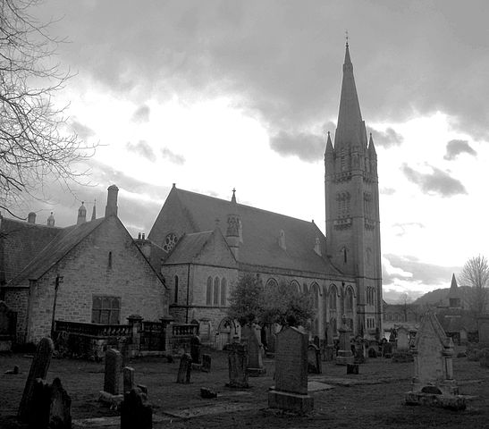
The Old High Church, the original parish church of Inverness and the oldest in the city, was already in existence at the time of the Battle of Culloden (1746) and Jacobite prisoners were summarily executed in the graveyard. There has been a church on the high mound, known as St Michael's Mount, for at least 900 years, and it is reputed that St Columba preached from the Mount when he visited Inverness to convert the Pictish King Brude to Christianity in 566. A pedestrian Lane, Church Lane runs from the Greig Street footbridge (over the River Ness) to Church Street between the Old High and its neighbour, the Free North Church (of the Free Church of Scotland). Designed by Alexander Ross of Inverness in the Gothic style, the Free North was built in 1893 and has the highest spire and largest capacity of any church in Inverness. These are just two of the beaurtiful buildings to be seen in Inverness City Centre. Both churches are very photogenic, especially from the other side of the River Ness. The "bottom end" of Church Street in Inverness is a quieter part of the Town (City) Centre these days, and yet it contains some really old and beautiful buildings which really should attract more visitors. Grouped closely together between Church Street and Bank Street (River Ness) are the Dunbar Hospital, Old High Church and the Free North Church. At the top end of Church Lane is the Dunbar Hospital, alongside the lane (its graveyard running the length of the lane) is the Old High Church of Scotland, and at the foot of the lane facing the Greig Street footbridge over the River Ness is the Free North Church of the Free Church of Scotland. Either side of the steps in Chuch Street leading to the Old High Church are 18th century houses which add to the old-town appearance. |
| Date | |
| Source | Free North Church from Old High Churchyard Inverness Scotland 2014 - or 1914? |
| Author | Dave Conner from Inverness, Scotland |
| Camera location | | View this and other nearby images on: OpenStreetMap |
|---|
.jpg¶ms=057.479699_N_-004.228738_E_globe:Earth_type:camera_source:Flickr_&language=en)
Licensing
[edit].jpg&action=edit§ion=2)
- You are free:
- to share – to copy, distribute and transmit the work
- to remix – to adapt the work
- Under the following conditions:
- attribution – You must give appropriate credit, provide a link to the license, and indicate if changes were made. You may do so in any reasonable manner, but not in any way that suggests the licensor endorses you or your use.
| This image was originally posted to Flickr by conner395 at https://www.flickr.com/photos/91779914@N00/13175540043. It was reviewed on 15 December 2014 by FlickreviewR and was confirmed to be licensed under the terms of the cc-by-2.0. |
File history
Click on a date/time to view the file as it appeared at that time.
| Date/Time | Thumbnail | Dimensions | User | Comment | |
|---|---|---|---|---|---|
| current | 20:42, 15 December 2014 | | 3,332 × 2,924 (547 KB) | LasPo rocks (talk | contribs) | Transferred from Flickr via Flickr2Commons |
You cannot overwrite this file.
File usage on Commons
There are no pages that use this file.
.jpg&oldid=888334691)