File:French Proposal 4 April 1946.jpg
Jump to navigation
Jump to search
Size of this preview: 457 × 599 pixels. Other resolutions: 183 × 240 pixels | 366 × 480 pixels | 641 × 840 pixels.
Original file (641 × 840 pixels, file size: 124 KB, MIME type: image/jpeg)
Captions
Captions
Add a one-line explanation of what this file represents
Summary[edit]
| Description |
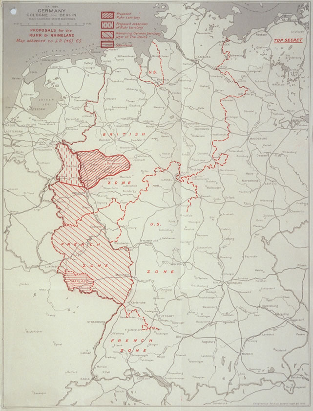
English: French Proposal for the Ruhr Area and the Rhineland. 日本語: ルール地域とラインラントに関するフランスの提案を示した地図。英国が作成。 |
| Date | |
| Source | http://zis.uibk.ac.at:81/zisneu/dokumente/karten/4.php |
| Author | The UK Chiefs of Staff Committee |
Licensing[edit]
This work created by the United Kingdom Government is in the public domain.
This is because it is one of the following:
HMSO has declared that the expiry of Crown Copyrights applies worldwide (ref: HMSO Email Reply)
|
 |
Original upload log[edit]
The original description page was here. All following user names refer to en.wikipedia.
- 2008-07-06 14:34 Stor stark7 641×840× (126817 bytes) {{Information |Description= French Proposal for the Ruhr Area and the Rhineland. |Source=http://zis.uibk.ac.at:81/zisneu/dokumente/karten/4.php |Date=4.4.1946 |Author=The UK Chiefs of Staff Committee |Permission= UK crown copyright (which is what applies
File history
Click on a date/time to view the file as it appeared at that time.
| Date/Time | Thumbnail | Dimensions | User | Comment | |
|---|---|---|---|---|---|
| current | 09:39, 28 August 2011 | | 641 × 840 (124 KB) | Lombroso (talk | contribs) |
You cannot overwrite this file.
File usage on Commons
There are no pages that use this file.
File usage on other wikis
The following other wikis use this file:
- Usage on ar.wikipedia.org
- Usage on ca.wikipedia.org
- Usage on de.wikipedia.org
- Usage on es.wikipedia.org
- Usage on et.wikipedia.org
- Usage on fr.wikipedia.org
- Plan Monnet
- Discussion:Plan Monnet
- Wikipédia:Statistiques des anecdotes de la page d'accueil/Visibilité des anecdotes (2017)
- Wikipédia:Le saviez-vous ?/Anecdotes proposées/Archivage des discussions/Archives/2017-1
- Wikipédia:Statistiques des anecdotes de la page d'accueil/Visibilité des anecdotes (2017)/2017 03
- Wikipédia:Le saviez-vous ?/Archives/2017
- Usage on it.wikipedia.org
- Usage on ja.wikipedia.org
- Usage on no.wikipedia.org
- Usage on vi.wikipedia.org
- Usage on zh.wikipedia.org