File:Froidmont, section de la commune de Tournai (Doornik) — Croix Notre Dame.jpg
Jump to navigation
Jump to search

Size of this preview: 398 × 600 pixels. Other resolutions: 159 × 240 pixels | 318 × 480 pixels | 510 × 768 pixels | 680 × 1,024 pixels | 1,359 × 2,048 pixels | 3,413 × 5,141 pixels.
Original file (3,413 × 5,141 pixels, file size: 3.22 MB, MIME type: image/jpeg)
Captions
Captions
Add a one-line explanation of what this file represents
Summary
[edit]_%E2%80%94_Croix_Notre_Dame.jpg&action=edit§ion=1)
| Description |
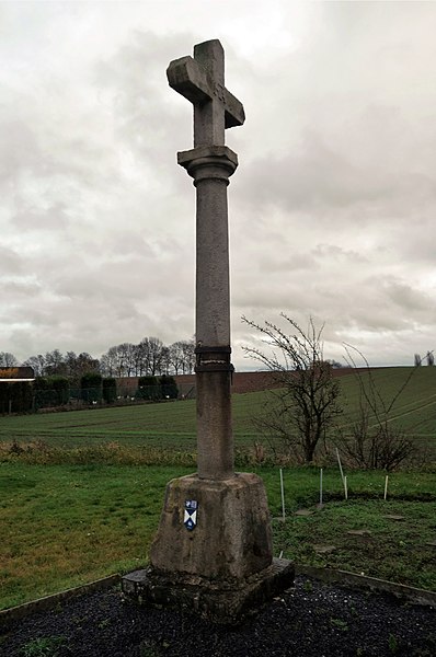
Français : Froimont, section de la Commune de Tournai – Croix Notre-Dame, également dénommée 'Croix Saint Pierre'*.
La croix Notre-Dame est un calvaire en pierre datant du XVIIe siècle. L'ensemble est composée d’un socle trapézoïdal en pierre et d’une colonne toscane à chapiteau surmontée de la croix ; le tout d'une hauteur d'environ cinq mètres. On retrouve mention d’un calvaire situé à cet emplacement dès le XVe siècle. La croix marquait la limite de la ville. Source de l'information : Institut du Patrimoine Wallon . Voir / See / voor meer informatie : https://www.cirkwi.com/fr/point-interet/184851-la-croix-notre-dame-a-froidmont
Nederlands: Stenen kruis genaamd "Croix Notre-Dame" Het kruis van Onze Lieve Vrouw.
(Froidmont is een dorp in de provincie Henegouwen, en een deelgemeente van de Waalse stad Doornik) Het kruis van Onze Lieve Vrouw is een stenen calvarieberg uit de 17e eeuw. Het ensemble bestaat uit een trapeziumvormige stenen basis en een Toscaanse zuil met een kapiteel met daarboven een kruis; alles vanaf een hoogte van ongeveer vijf meter. Het kruis markeerde de grens van de stad.English: The cross of Our Lady is a stone calvary dating from the 17th century. The ensemble consists of a trapezoidal stone base and a Tuscan column with a capital surmounted by the cross; all from a height of about five metres. There is mention of a calvary located at this site as early as the 15th century. The cross marked the boundary of the city.
|
||
| Date | |||
| Source | Own work | ||
| Author | Jpcuvelier | ||
| Other versions | https://www.pop.culture.gouv.fr/notice/memoire/APDCL07009?auteur=%5B => René Desclée ºTournai 1868 †Tournai 1953 → http://www2.culture.gouv.fr/public/mistral/autor_fr?ACTION=CHERCHER&FIELD_98=REF&VALUE_98=AW00110 |
| Camera location | | View this and other nearby images on: OpenStreetMap |
|---|
_%E2%80%94_Croix_Notre_Dame.jpg¶ms=050.585584_N_0003.343226_E_globe:Earth_type:camera__&language=en)
Licensing
[edit]_%E2%80%94_Croix_Notre_Dame.jpg&action=edit§ion=2)
I, the copyright holder of this work, hereby publish it under the following license:
This file is licensed under the Creative Commons Attribution-Share Alike 4.0 International license.
- You are free:
- to share – to copy, distribute and transmit the work
- to remix – to adapt the work
- Under the following conditions:
- attribution – You must give appropriate credit, provide a link to the license, and indicate if changes were made. You may do so in any reasonable manner, but not in any way that suggests the licensor endorses you or your use.
- share alike – If you remix, transform, or build upon the material, you must distribute your contributions under the same or compatible license as the original.
File history
Click on a date/time to view the file as it appeared at that time.
| Date/Time | Thumbnail | Dimensions | User | Comment | |
|---|---|---|---|---|---|
| current | 23:35, 10 August 2019 | | 3,413 × 5,141 (3.22 MB) | Henxter (talk | contribs) | Cropped 1 % horizontally, 1 % vertically using CropTool with precise mode. |
| 16:38, 28 February 2019 |  | 3,455 × 5,171 (3.34 MB) | Jpcuvelier (talk | contribs) | User created page with UploadWizard |
You cannot overwrite this file.
File usage on Commons
The following page uses this file:
File usage on other wikis
The following other wikis use this file:
- Usage on fr.wikipedia.org
- Usage on nl.wikipedia.org
_—_Croix_Notre_Dame.jpg&oldid=702825924)