File:From Mr. Bothfeld's survey of 1875 for U.S. Eng'rs (details omitted) - (waters southwest of Lovell Island, Boston, Massachusetts). LOC 90680299.jpg
Jump to navigation
Jump to search

Size of this preview: 799 × 359 pixels. Other resolutions: 320 × 144 pixels | 640 × 288 pixels | 1,024 × 460 pixels | 1,280 × 575 pixels | 2,560 × 1,150 pixels | 7,727 × 3,472 pixels.
Original file (7,727 × 3,472 pixels, file size: 3.39 MB, MIME type: image/jpeg)
Captions
Captions
Add a one-line explanation of what this file represents
Summary
[edit]| Description |
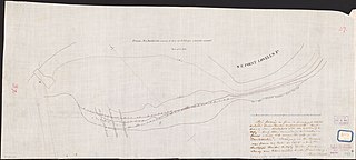
English: Ms. nautical chart showing contemporary shoreline and shorelines before dredging. Depths shown by contours and soundings. At lower left in lead pencil: Mr. Bothfeld's plotting of position of "Constellation." "This tracing is from a [progress?] sketch entitled 'Boston Harbor Improvements' lent to me by Mr. Bothfeld ... 1878 ... [signed] N. Mitchell." Oriented with north toward the upper left. Black, red, and brown inks, lead pencil, and red pencil. Rubber-stamped at lower right. Includes text. In ink on adhesive label at lower right: 844H 1878. In red pencil: 37-. Available also through the Library of Congress Web site as a raster image. Vault |
||
| Title | From Mr. Bothfeld's survey of 1875 for U.S. Eng'rs (details omitted) : [waters southwest of Lovell Island, Boston, Massachusetts]. | ||
| Shelf ID | G3762.L56P5 1878 .B6 | ||
| Date | |||
| Source | https://www.loc.gov/item/90680299/ | ||
| Author | Bothfeld; Mitchell, N.; United States. Army. Corps Of Engineers | ||
| Permission (Reusing this file) |
|
||
| Other versions |
|
||
| Location | United States · Boston · Massachusetts · Lovell Island Region | ||
| Part of | American Memory · General Maps · Catalog · Geography And Map Division | ||
| Subject | Maps, Manuscript · Lovell Island Region (Boston, Mass.) · Lovell Island Region (Boston) · Boston · Nautical Charts · United States · Massachusetts · Lovell Island Region · Manuscript Maps |


_-_(waters_southwest_of_Lovell_Island,_Boston,_Massachusetts)._LOC_90680299.jpg&action=edit§ion=1)
Licensing
[edit]_-_(waters_southwest_of_Lovell_Island,_Boston,_Massachusetts)._LOC_90680299.jpg&action=edit§ion=2)
|
This is a faithful photographic reproduction of a two-dimensional, public domain work of art. The work of art itself is in the public domain for the following reason:
The official position taken by the Wikimedia Foundation is that "faithful reproductions of two-dimensional public domain works of art are public domain".
This photographic reproduction is therefore also considered to be in the public domain in the United States. In other jurisdictions, re-use of this content may be restricted; see Reuse of PD-Art photographs for details. | ||||
File history
Click on a date/time to view the file as it appeared at that time.
| Date/Time | Thumbnail | Dimensions | User | Comment | |
|---|---|---|---|---|---|
| current | 22:39, 17 June 2018 | | 7,727 × 3,472 (3.39 MB) | Fæ (talk | contribs) | LOC Maps https://www.loc.gov/item/90680299/ #19017 |
You cannot overwrite this file.
File usage on Commons
The following page uses this file:
_-_(waters_southwest_of_Lovell_Island,_Boston,_Massachusetts)._LOC_90680299.jpg&oldid=493472076)