File:Ft-Ruckman-Map.jpg

Original file (895 × 609 pixels, file size: 105 KB, MIME type: image/jpeg)
Captions
Captions
Summary[edit]
| Description |
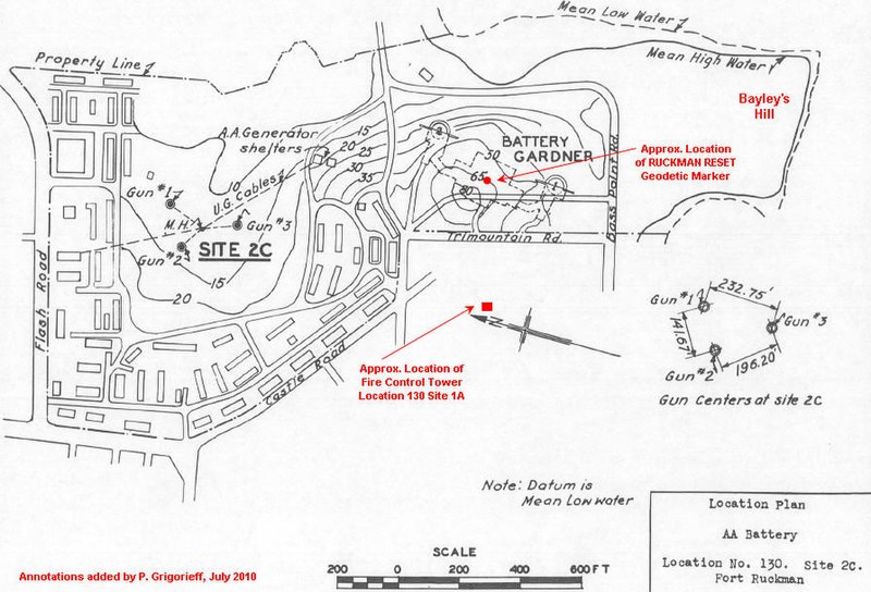
English: This map of Fort Ruckman is from the U.S. Army Engineers' 1945 Report on the Harbor Defenses of Boston, and was meant as an aid to locating the WW2 battery of three anti-aircraft guns NW of the fort (at "Site 2C"). The boundary of the fort is indicated by the dashed line.
Battery Gardner, the site of the fort's two 12-inch guns, is clearly shown, with its (dashed line) underground chambers and magazines. The surface area above this emplacement is now a public park, as is the entire point marked "Bayley's Hill" and east of Bass Point Rd. The elongated structures shown all around Site 2C were temporary WW2 era barracks and utility buildings. A 1938 map of the fort shows only one structure as belonging to the post. Today, almost all of the area south of Flash Rd. and east of Castle Rd. is covered with parks and recreation space, municipal facilities, or private homes. None of the temporary structures included on this map seems to have survived. The annotations in red were added by the contributor. |
| Date | c. 1945 ? |
| Source | U.S. Army Engineers' 1945 Report on the Harbor Defenses of Boston |
| Author |
Licensing[edit]
This file is a work of a U.S. Army soldier or employee, taken or made as part of that person's official duties. As a work of the U.S. federal government, it is in the public domain in the United States.
|
 |
File history
Click on a date/time to view the file as it appeared at that time.
| Date/Time | Thumbnail | Dimensions | User | Comment | |
|---|---|---|---|---|---|
| current | 16:46, 10 July 2010 | | 895 × 609 (105 KB) | Pgrig (talk | contribs) | This map of Fort Ruckman is from the U.S. Army Engineers' 1945 Report on the Harbor Defenses of Boston, and was meant as an aid to locating the WW2 battery of three anti-aircraft guns NW of the fort (at "Site 2C"). The boundary of the fort is indicated by |
You cannot overwrite this file.
File usage on Commons
There are no pages that use this file.
File usage on other wikis
The following other wikis use this file:
- Usage on en.wikipedia.org