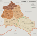
File:General Government for the occupied Polish territories (1941).png
跳转到导航
跳转到搜索

本预览的尺寸:605 × 600像素。 其他分辨率:242 × 240像素 | 484 × 480像素 | 774 × 768像素 | 1,033 × 1,024像素 | 2,299 × 2,280像素。
原始文件 (2,299 × 2,280像素,文件大小:543 KB,MIME类型:image/png)
分类:
- Maps of the General Government
- Maps of Poland during World War II
- Maps of Ukraine in World War II
- Distrikt Krakau, General Government 1939-1945
- Distrikt Warschau, General Government 1939-1945
- Distrikt Lublin, General Government 1939-1945
- Distrikt Radom, General Government 1939-1945
- Maps of Distrikt Galizien, General Government 1941-1944


