File:General Karte von Ost-West-Süd und Neu-Ostpreussen, dem Grenz-Tractate vom Jahre 1797... - von D. F. Sotzmann... ; gestochen von Carl Jäck - btv1b53027522v.jpg
Jump to navigation
Jump to search

Size of this preview: 694 × 600 pixels. Other resolutions: 278 × 240 pixels | 556 × 480 pixels | 889 × 768 pixels | 1,185 × 1,024 pixels | 2,370 × 2,048 pixels | 6,567 × 5,674 pixels.
Original file (6,567 × 5,674 pixels, file size: 7.46 MB, MIME type: image/jpeg)
Captions
Captions
Add a one-line explanation of what this file represents
Summary
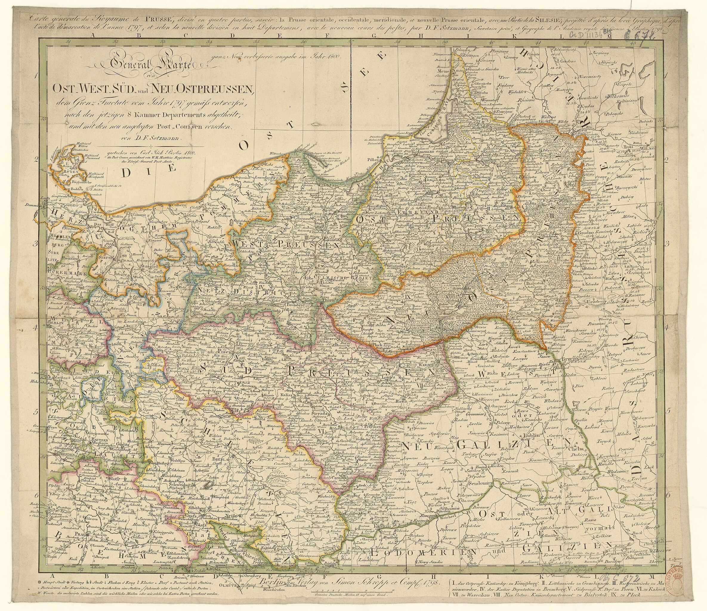
[edit]| General Karte von Ost-West-Süd und Neu-Ostpreussen, dem Grenz-Tractate vom Jahre 1797... / von D. F. Sotzmann... ; gestochen von Carl Jäck
Alternative title: Carte générale du Royaume de Prusse, ... / par D. F. Sotzmann ( |
|||||||||||||||||||||||||||
|---|---|---|---|---|---|---|---|---|---|---|---|---|---|---|---|---|---|---|---|---|---|---|---|---|---|---|---|
| Author |
Sotzmann, Daniel Friedrich (1754-1840). Cartographe Jäck, Carl (1763-1808). Graveur |
||||||||||||||||||||||||||
| Title |
General Karte von Ost-West-Süd und Neu-Ostpreussen, dem Grenz-Tractate vom Jahre 1797... / von D. F. Sotzmann... ; gestochen von Carl Jäck Alternative title:Carte générale du Royaume de Prusse, ... / par D. F. Sotzmann |
||||||||||||||||||||||||||
| Description |
Français : Sujet : Divisions politiques et administratives
Prusse, Royaume de -- Est -- Divisions politiques et administratives Échelle(s) : 15 Gemeine Deutsche Meilen 15 auf einen Grad. [= 6,3 cm] Couverture : Pologne Langue : français allemand Éditeur : S. Schropp (Berlin) |
||||||||||||||||||||||||||
| Date | 1798 | ||||||||||||||||||||||||||
| Dimensions | height: 53 cm (20.8 in); width: 47 cm (18.5 in) | ||||||||||||||||||||||||||
| Collection |
|
||||||||||||||||||||||||||
| References |
Français : Notice du catalogue : http://catalogue.bnf.fr/ark:/12148/cb40742207z |
||||||||||||||||||||||||||
| Source/Photographer |
Français : Bibliothèque nationale de France, département Cartes et plans, GE D-11134 (BIS)
Bibliothèque nationale de France |
||||||||||||||||||||||||||
| Permission (Reusing this file) |
|
||||||||||||||||||||||||||

File history
Click on a date/time to view the file as it appeared at that time.
| Date/Time | Thumbnail | Dimensions | User | Comment | |
|---|---|---|---|---|---|
| current | 19:53, 15 July 2022 | | 6,567 × 5,674 (7.46 MB) | Gzen92Bot (talk | contribs) | Gallica btv1b53027522v |
You cannot overwrite this file.
File usage on Commons
The following page uses this file: