File:Germany, Federal Republic of location map 23 May 1949 - 6 Oct 1949.svg

Rozmiar pierwotny (Plik SVG, nominalnie 1075 × 1273 pikseli, rozmiar pliku: 1,12 MB)
Podpisy
Podpisy
Opis[edytuj]
| Opis |
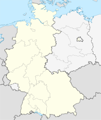
Deutsch: Positionskarte der Bundesrepublik Deutschland. Diese Karte zeigt die Bundesrepublik im Gebietsstand zwischen 23. Mai 1949 bis 6. Oktober 1949.
Quadratische Plattkarte, N-S-Streckung 150 %. Geographische Begrenzung der Karte:
English: Location map of Federal Republic of Germany. Map shows West-Germany as of May 23rd 1949 till October 6th 1949.
Equirectangular projection, N/S stretching 150 %. Geographic limits of the map:
|
||
| Data | Created in 2009 | ||
| Źródło | own work, based on File:Germany location map 23 April 1949 - 22 May 1949.svg | ||
| Autor | TUBS | ||
| Licencja (Ponowne użycie tego pliku) |
Ja, właściciel praw autorskich do tego dzieła, udostępniam je na poniższych licencjach
Ten plik udostępniony jest na licencji Creative Commons Uznanie autorstwa – Na tych samych warunkach 3.0.
Możesz wybrać, którą licencję chcesz zastosować. |
||
| Inne wersje |
Bundesrepublik Deutschland (vor 1990 nur West-Deutschland):
Deutsche Demokratische Republik (mit BRD im Ausschnitt):
Ostdeutschland (vor 1990 Deutsche Demokratische Republik):
Deutschland zwischen Mai 1945 und Oktober 1949:
Thematisch:
Deutsches Reich (1918–1945) (best used with this template (de)):
|


_23_May_1949_-_6_Oct_1949.svg)


_location_map.svg)
_location_map_2013.svg)


Historia pliku
Kliknij na odpowiedniej dacie/czasie, aby zobaczyć wersję pliku z tamtego okresu.
| Data/czas | Miniatura | Wymiary | Użytkownik | Opis | |
|---|---|---|---|---|---|
| aktualny | 07:53, 30 kwi 2010 | | 1075 × 1273 (1,12 MB) | TUBS (dyskusja | edycje) | == {{int:filedesc}} == {{Information |Description= {{de|Positionskarte der Bundesrepublik Deutschland. Diese Karte zeigt die Bundesrepublik im Gebietsstand zwischen 23. Mai 1949 bis 6. Oktober 1949.}} Quadratische Plattkarte, N-S-Strec |
Nie możesz nadpisać tego pliku.
Lokalne wykorzystanie pliku
Następujące strony korzystają z tego pliku:
- File:Deutschland Autobahnen.svg
- File:East-West-Germany-October 1949-July 1952.svg
- File:East Germany location map.svg
- File:Germany, Federal Republic of location map 23 May 1949 - 6 Oct 1949.svg
- File:Germany, Federal Republic of location map April 1952 - August 1955.svg
- File:Germany, Federal Republic of location map December 1950 - April 1952.svg
- File:Germany, Federal Republic of location map January 1957 - October 1990.svg
- File:Germany, Federal Republic of location map October 1949 - November 1950.svg
- File:Germany, Federal Republic of location map September 1955 - December 1956.svg
- File:Germany, German Democratic Republic location map January 1957 - October 1990.svg
- File:Germany, German Democratic Republic location map July 1952 - January 1957.svg
- File:Germany, German Democratic Republic location map October 1949 - July 1952.svg
- File:Germany, German Democratic Republic location map w·o FRG July 1952 - October 1990.svg
- File:Germany, German Democratic Republic location map w·o FRG October 1949 - June 1952.svg
- File:Germany, location map (SBZ perspective) 23 May 1949 - 6 Oct 1949.svg
- File:Germany2 location map.svg
- File:Germany location map.svg
- File:Germany location map 23 April 1949 - 22 May 1949.svg
- File:Germany location map 8 Jun 1947 - 22 Apr 1949.svg
- File:Germany location map April 1992 - July 1992.svg
- File:Germany location map August 1992 - June 1993.svg
- File:Germany location map July 1993 - December 2009.svg
- File:Germany location map October 1990 - March 1992.svg
- File:Germany location map labeled 8 Jun 1947 - 22 Apr 1949.svg
- File:Lage Freiberg in Deutschland.png
- File:Relief Map of Germany.png
- File:Relief Map of Germany.svg
- Template:Germany location map/other versions
Globalne wykorzystanie pliku
Ten plik jest wykorzystywany także w innych projektach wiki:
- Wykorzystanie na pl.wikipedia.org
- Wykorzystanie na pl.wikibooks.org