File:Germany (+districts) location map.svg
Aller à la navigation
Aller à la recherche

Taille de cet aperçu PNG pour ce fichier SVG : 506 × 600 pixels. Autres résolutions : 202 × 240 pixels | 405 × 480 pixels | 648 × 768 pixels | 864 × 1 024 pixels | 1 728 × 2 048 pixels | 1 073 × 1 272 pixels.
Fichier d’origine (Fichier SVG, nominalement de 1 073 × 1 272 pixels, taille : 2,21 Mio)
Légendes
Légendes
Ajoutez en une ligne la description de ce que représente ce fichier
Description[modifier]
_location_map.svg&action=edit§ion=1)
| Description |
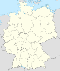
Deutsch: Positionskarte von Deutschland mit Grenzen der Regierungsbezirke und Landkreise
Quadratische Plattkarte, N-S-Streckung 150 %. Geographische Begrenzung der Karte:
English: Location map of Germany with waterbodies
Equirectangular projection, N/S stretching 150 %. Geographic limits of the map:
|
| Date | |
| Source |
Travail personnel Cette image vectorielle non W3C-spécifiée a été créée avec Adobe Illustrator. Ce fichier a été téléversé avec Commonist. Cette image vectorielle contient des éléments, éventuellement modifiés, qui ont été extraits de : Cette image vectorielle contient des éléments, éventuellement modifiés, qui ont été extraits de : |
| Auteur |
TUBS |
| Autres versions |
_-_de_-_colored.svg) |
Conditions d’utilisation[modifier]
_location_map.svg&action=edit§ion=2)
Moi, en tant que détenteur des droits d’auteur sur cette œuvre, je la publie sous les licences suivantes :
Ce fichier est disponible selon les termes de la licence Creative Commons Attribution – Partage dans les Mêmes Conditions 3.0 (non transposée).
- Vous êtes libre :
- de partager – de copier, distribuer et transmettre cette œuvre
- d’adapter – de modifier cette œuvre
- Sous les conditions suivantes :
- paternité – Vous devez donner les informations appropriées concernant l'auteur, fournir un lien vers la licence et indiquer si des modifications ont été faites. Vous pouvez faire cela par tout moyen raisonnable, mais en aucune façon suggérant que l’auteur vous soutient ou approuve l’utilisation que vous en faites.
- partage à l’identique – Si vous modifiez, transformez, ou vous basez sur cette œuvre, vous devez distribuer votre contribution sous la même licence ou une licence compatible avec celle de l’original.

|
Vous avez la permission de copier, distribuer et modifier ce document selon les termes de la GNU Free Documentation License version 1.2 ou toute version ultérieure publiée par la Free Software Foundation, sans sections inaltérables, sans texte de première page de couverture et sans texte de dernière page de couverture. Un exemplaire de la licence est inclus dans la section intitulée GNU Free Documentation License. |
Vous pouvez choisir l’une de ces licences.

|
J'apprécierais que vous attribuiez ce média à Wikimedia Commons, s’il est utilisé en dehors de Wikipédia ou Wikimedia Commons. Pour une utilisation dans des publications (telles que livres, journaux, blogs, sites Web, etc), veuillez insérer la ligne suivante dans sa page de discussion :
|
_location_map.svg)
Historique du fichier
Cliquer sur une date et heure pour voir le fichier tel qu'il était à ce moment-là.
| Date et heure | Vignette | Dimensions | Utilisateur | Commentaire | |
|---|---|---|---|---|---|
| actuel | 14 mai 2022 à 12:40 | | 1 073 × 1 272 (2,21 Mio) | TUBS (d | contributions) | erlangen + höchstadt - double borders |
| 14 mai 2022 à 12:18 |  | 1 073 × 1 272 (4,18 Mio) | TUBS (d | contributions) | Reverted to version as of 09:22, 14 February 2020 (UTC): reverted. Did more harm than good (esp. concering islands in the Baltic and North See) and double/ghost borders. Will deal with the Franconian issue later. | |
| 7 décembre 2021 à 08:49 |  | 1 073 × 1 272 (4,15 Mio) | TUBS (d | contributions) | erlangen + höchstadt vereint | |
| 14 février 2020 à 09:22 |  | 1 073 × 1 272 (4,18 Mio) | TUBS (d | contributions) | pushed LK Kehlheim to the right Bezirk. ((This is not an update. Some districts have merged by now, e.g. Göttignen/Osterode. Some borders have changed as of February 2020. Don't have the time to redraw the map.) | |
| 29 octobre 2013 à 13:01 |  | 1 073 × 1 272 (3,17 Mio) | TUBS (d | contributions) | ||
| 29 octobre 2013 à 12:52 |  | 1 073 × 1 272 (1,61 Mio) | TUBS (d | contributions) | real loc map | |
| 28 octobre 2013 à 18:44 |  | 1 073 × 1 272 (5,82 Mio) | TUBS (d | contributions) | == {{int:filedesc}} == {{Information |Description={{de|Karte der politischen Gliederung Deutschlands in Länder, Regierungsbezirke, Landkreise und krsfr. Städte}} {{en|Map of administrative divisions of Germany. States, government districts, districts... |
Vous ne pouvez pas remplacer ce fichier.
Utilisations locales du fichier
Les 32 pages suivantes utilisent ce fichier :
- File:Deutschland Autobahnen.svg
- File:East-West-Germany-October 1949-July 1952.svg
- File:East Germany location map.svg
- File:Germany, Federal Republic of location map 23 May 1949 - 6 Oct 1949.svg
- File:Germany, Federal Republic of location map April 1952 - August 1955.svg
- File:Germany, Federal Republic of location map December 1950 - April 1952.svg
- File:Germany, Federal Republic of location map January 1957 - October 1990.svg
- File:Germany, Federal Republic of location map October 1949 - November 1950.svg
- File:Germany, Federal Republic of location map September 1955 - December 1956.svg
- File:Germany, German Democratic Republic location map January 1957 - October 1990.svg
- File:Germany, German Democratic Republic location map July 1952 - January 1957.svg
- File:Germany, German Democratic Republic location map October 1949 - July 1952.svg
- File:Germany, German Democratic Republic location map w·o FRG July 1952 - October 1990.svg
- File:Germany, German Democratic Republic location map w·o FRG October 1949 - June 1952.svg
- File:Germany, administrative divisions (+districts) - de - colored.svg
- File:Germany, location map (SBZ perspective) 23 May 1949 - 6 Oct 1949.svg
- File:Germany2 location map.svg
- File:Germany (+districts +municipalities) location map.png
- File:Germany (+districts +municipalities) location map 2013.svg
- File:Germany (+districts +municipalities) location map current.svg
- File:Germany location map.svg
- File:Germany location map 23 April 1949 - 22 May 1949.svg
- File:Germany location map 8 Jun 1947 - 22 Apr 1949.svg
- File:Germany location map April 1992 - July 1992.svg
- File:Germany location map August 1992 - June 1993.svg
- File:Germany location map July 1993 - December 2009.svg
- File:Germany location map October 1990 - March 1992.svg
- File:Germany location map labeled 8 Jun 1947 - 22 Apr 1949.svg
- File:Lage Freiberg in Deutschland.png
- File:Relief Map of Germany.png
- File:Relief Map of Germany.svg
- Template:Germany location map/other versions
_23_May_1949_-_6_Oct_1949.svg)
_location_map.png)
_location_map_2013.svg)
_location_map_current.svg)
Utilisations du fichier sur d’autres wikis
Les autres wikis suivants utilisent ce fichier :
- Utilisation sur de.wikipedia.org
_location_map.svg&oldid=655989313)