File:Germany (2), Neuwerk, Scharhörn, Nigehörn.jpg
维基共享资源,媒体文件资料库
跳转到导航
跳转到搜索

本预览的尺寸:691 × 600像素。 其他分辨率:277 × 240像素 | 553 × 480像素 | 885 × 768像素 | 1,180 × 1,024像素 | 1,941 × 1,684像素。
原始文件 (1,941 × 1,684像素,文件大小:550 KB,MIME类型:image/jpeg)
文件信息
结构化数据
说明
说明
添加一行文字以描述该文件所表现的内容
摘要
[编辑]| 描述Germany (2), Neuwerk, Scharhörn, Nigehörn.jpg |
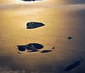
English: Aerial picture of the Hamburg Wadden Sea National Park (German: Nationalpark Hamburgisches Wattenmeer). This park is an exclave of the city state of Hamburg and lies 12.5 km off Cuxhaven in the estuary of the Elbe in the North Sea. The park includes the islands of Neuwerk (above), Scharhörn and Nigehörn (below, appearing as a single island in this picture taken at low tide). The two other islands (right and below right) are parts of the Scharhörn and Neuwerk mudflats (Scharhörner und Neuwerker Watt). Viewing direction is toward the SE.
Nederlands: Luchtfoto van het Hamburgse Nationale Park Waddenzee (Duits: Nationalpark Hamburgisches Wattenmeer). Dit park is een exclave van de stadstaat Hamburg en ligt 12.5 ten NW van Cuxhaven in de monding van de Elbe in de Noordzee. Het park omvat de eilanden Neuwerk (boven), Scharhörn en Nigehörn (die op de foto op één eiland lijken). De twee andere eilanden (rechts en rechts onder) zijn delen van het Scharhörnse en Neuwerkse Wad (Scharhörner und Neuwerker Watt). Blikrichting is naar het zuidoosten. |
| 日期 | |
| 来源 | 自己的作品 |
| 作者 | Vincent van Zeijst |
| 授权 (二次使用本文件) |
本文件采用知识共享署名-相同方式共享 3.0 未本地化版本许可协议授权。
|
| 相机位置 | 53° 59′ 53.1″ 北, 8° 20′ 19.04″ 东 | 在以下服务上查看本图像和附近其他图像: OpenStreetMap |
|---|
| 註解 InfoField | 該圖片含有註解:在維基媒體共享資源上查看註解 |
402
3
520
53
1941
1684
Cuxhaven
3
3
152
1370
1941
1684
Elbe
文件历史
点击某个日期/时间查看对应时刻的文件。
| 日期/时间 | 缩略图 | 大小 | 用户 | 备注 | |
|---|---|---|---|---|---|
| 当前 | 2017年12月27日 (三) 13:59 |  | 1,941 × 1,684(550 KB) | Aeroid(留言 | 贡献) | dust removal |
| 2011年3月26日 (六) 16:59 |  | 1,941 × 1,684(543 KB) | Loranchet(留言 | 贡献) | {{Information |Description ={{en|1=Aerial picture of the Hamburg Wadden Sea National Park (German: Nationalpark Hamburgisches Wattenmeer). This park is an exclave of the city state of Hamburg and lies 12.5 km off Cuxhaven in the estuary of the Elbe in |
您不可以覆盖此文件。
文件用途
全域文件用途
以下其他wiki使用此文件:
- az.wikipedia.org上的用途
- ban.wikipedia.org上的用途
- de.wikipedia.org上的用途
- en.wikipedia.org上的用途
- fa.wikipedia.org上的用途
- hsb.wikipedia.org上的用途
- mk.wikipedia.org上的用途
- nl.wikipedia.org上的用途
- pl.wikipedia.org上的用途
- sv.wikipedia.org上的用途
- tr.wikipedia.org上的用途
- ur.wikipedia.org上的用途
- vi.wikipedia.org上的用途
- zh.wikipedia.org上的用途
元数据
此文件含有额外信息,这些信息可能是创建或数字化该文件时使用的数码相机或扫描仪所添加的。如果文件已从其原始状态修改,某些详细信息可能无法完全反映修改后的文件。
| 相机制造商 | NIKON CORPORATION |
|---|---|
| 相机型号 | NIKON D5000 |
| 曝光时间 | 1/500秒(0.002) |
| 光圈值 | f/11 |
| 感光度(ISO) | 200 |
| 数据生成日期时间 | 2010年10月18日 (一) 08:40 |
| 镜头焦距 | 52毫米 |
| 宽度 | 1,941 px |
| 高度 | 1,684 px |
| 每色彩组分位数 |
|
| 像素构成 | RGB |
| 方向 | 正常 |
| 色彩组分数 | 3 |
| 水平分辨率 | 300 dpi |
| 垂直分辨率 | 300 dpi |
| 使用软件 | Adobe Photoshop CC (Windows) |
| 文件修改日期时间 | 2017年12月27日 (三) 14:48 |
| 亮度(Y)和色度(C)位置 | 重叠 |
| 曝光程序 | 未定义 |
| Exif版本 | 2.21 |
| 数字化日期时间 | 2010年10月18日 (一) 08:40 |
| 每个色彩组分意义 |
|
| 图像压缩模式 | 2 |
| APEX快门速度 | 8.965784 |
| APEX光圈 | 6.918863 |
| APEX曝光补偿 | 0 |
| 最大光圈 | 4.6 APEX(f/4.92) |
| 测光模式 | 多区 |
| 光源 | 未知 |
| 闪光灯 | 闪光灯未点亮、自动模式 |
| 修改时间厘秒数 | 50 |
| 数据生成时间厘秒数 | 50 |
| 数字化时间厘秒数 | 50 |
| 支持的Flashpix版本 | 1 |
| 色彩空间 | sRGB |
| 感光方法 | 单芯片彩色区域传感器 |
| 文件来源 | 数码相机 |
| 场景类型 | 直接拍摄的图像 |
| 自订图像处理 | 普通处理 |
| 曝光模式 | 自动曝光 |
| 白平衡 | 自动白平衡 |
| 数字变焦比率 | 1 |
| 35毫米胶片焦距 | 78毫米 |
| 场景拍摄类型 | 标准 |
| 场景控制 | 无 |
| 对比度 | 标准 |
| 饱和度 | 标准 |
| 锐度 | 标准 |
| 拍摄对象距离范围 | 未知 |
| GPS标签版本 | 2.2.0.0 |
| 相机序列号 | 6300062 |
| 使用的镜头 | 18.0-105.0 mm f/3.5-5.6 |
| 元数据最后修改日期 | 2017年12月27日 (三) 15:48 |
| 原始文件唯一ID | E5C54542543F661DF11EA16F84B46692 |