File:Gettysburg and vicinity, showing the lines of battle, July, 1863. LOC 99447496.jpg
Jump to navigation
Jump to search

Size of this preview: 466 × 600 pixels. Other resolutions: 186 × 240 pixels | 373 × 480 pixels | 597 × 768 pixels | 796 × 1,024 pixels | 1,591 × 2,048 pixels | 4,132 × 5,317 pixels.
Original file (4,132 × 5,317 pixels, file size: 3.59 MB, MIME type: image/jpeg)
Captions
Captions
Add a one-line explanation of what this file represents
Summary[edit]
| Description |
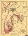
English: Scale 1:15,840. LC Civil War Maps (2nd ed.), 329 Inset: Site of Gen. Gregg's cavalry operations. Three miles east of Gettysburg. Uncolored. Scale. 1:63,360. 13 x 7 cm. Lower right corner: Compliments of Holtzworth Bros., propr's of the Ziegler and Holtzworth Livery, in rear of Eagle Hotel, Gettysburg, Pa. Shows drainage, vegetation, roads, railroads, fences, dwellings with names of inhabitants, and land owned by the United States. Union and Confederate positions are shown, with names of corps and divisions, sometimes including names of commanding officers, and location of artillery. See entry no. 334 for an earlier version of this map. Description derived from published bibliography. Available also through the Library of Congress web site as raster image. |
||
| Title | Gettysburg and vicinity, showing the lines of battle, July, 1863. | ||
| Shelf ID | G3824.G3S5 1863 .B8 | ||
| Date | |||
| Source | https://www.loc.gov/item/99447496/ | ||
| Author | Burk & Mcfetridge | ||
| Permission (Reusing this file) |
|
||
| Other versions |
|
||
| Location | Pennsylvania · United States · Gettysburg | ||
| Part of | Military Battles And Campaigns · American Memory · Civil War Maps · Catalog · Geography And Map Division | ||
| Subject | Pennsylvania · Gettysburg · Gettysburg, Battle Of, Gettysburg, Pa. · United States · Maps · Gettysburg (Pa.), Battle Of |

Licensing[edit]
|
This is a faithful photographic reproduction of a two-dimensional, public domain work of art. The work of art itself is in the public domain for the following reason:
The official position taken by the Wikimedia Foundation is that "faithful reproductions of two-dimensional public domain works of art are public domain".
This photographic reproduction is therefore also considered to be in the public domain in the United States. In other jurisdictions, re-use of this content may be restricted; see Reuse of PD-Art photographs for details. | ||||
File history
Click on a date/time to view the file as it appeared at that time.
| Date/Time | Thumbnail | Dimensions | User | Comment | |
|---|---|---|---|---|---|
| current | 09:42, 5 June 2018 | | 4,132 × 5,317 (3.59 MB) | Fæ (talk | contribs) | LOC Maps https://www.loc.gov/item/99447496/ #20671 |
You cannot overwrite this file.
File usage on Commons
The following page uses this file: