File:GlenCanyonDamm.jpg
Jump to navigation
Jump to search

Size of this preview: 800 × 260 pixels. Other resolutions: 320 × 104 pixels | 640 × 208 pixels | 1,024 × 333 pixels | 1,280 × 416 pixels | 2,560 × 832 pixels | 10,231 × 3,326 pixels.
Original file (10,231 × 3,326 pixels, file size: 4.36 MB, MIME type: image/jpeg)
Captions
Captions
Add a one-line explanation of what this file represents
Summary
[edit]| Description |
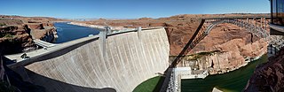
Deutsch: Glen Canyon Damm |
| Date | |
| Source | Jacques Kohler |
| Author | Jacques Kohler (Wikipedia: Archijack) |
| Camera location | | View this and other nearby images on: OpenStreetMap |
|---|
Licensing
[edit]This file is licensed under the Creative Commons Attribution 3.0 Germany license.
- You are free:
- to share – to copy, distribute and transmit the work
- to remix – to adapt the work
- Under the following conditions:
- attribution – You must give appropriate credit, provide a link to the license, and indicate if changes were made. You may do so in any reasonable manner, but not in any way that suggests the licensor endorses you or your use.

Original upload log
[edit]Transferred from de.wikipedia to Commons by Wdwdbot using script bot_filetrans.pl (r80:81M).
The original description page was here. All following user names refer to de.wikipedia.
- 2011-01-02 18:44:29 Archijack (4571491 Bytes) {{Information |Beschreibung = Glen Canyon Damm |Quelle = Jacques Kohler |Urheber = Jacques Kohler |Datum = 08.10.2010 |Genehmigung = |Andere Versionen = |Anmerkungen = }}

File history
Click on a date/time to view the file as it appeared at that time.
| Date/Time | Thumbnail | Dimensions | User | Comment | |
|---|---|---|---|---|---|
| current | 21:50, 16 February 2017 | 10,231 × 3,326 (4.36 MB) | Wdwdbot (talk | contribs) | Bot Move: Original uploader of this revision (#1) was Archijack at de.wikipedia |
You cannot overwrite this file.
File usage on Commons
There are no pages that use this file.
File usage on other wikis
The following other wikis use this file:
- Usage on de.wikipedia.org