File:Gorgeous Green along the Nile River (MODIS).jpg

Original file (2,910 × 2,132 pixels, file size: 522 KB, MIME type: image/jpeg)
Captions
Captions
Summary
[edit].jpg&action=edit§ion=1)
| Description |
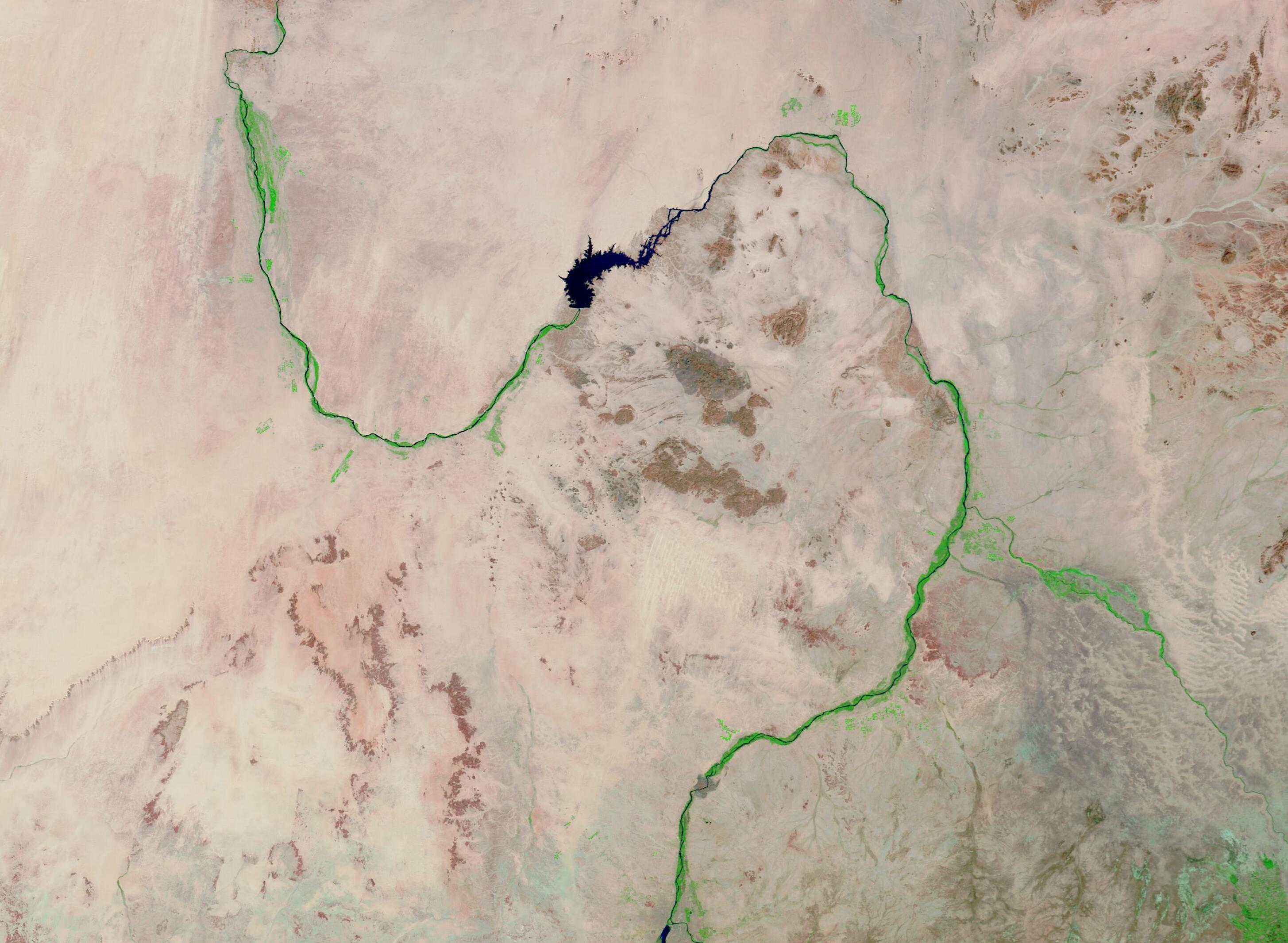
English: Over the span of millennia, the Nile River has provided a critical lifeline as it courses through some of the driest landscape on Earth.
Originating in the rivers that enter into Lake Victoria (located in modern-day Uganda, Tanzania, and Kenya), the Nile flows northward for more than 4,100 miles (6,600 km) through eastern Africa to end at the Mediterranean Sea. The northern Nile passes through the Saharan Desert in Egypt and Sudan, providing life-sustaining water for drinking, agriculture, and fishing, as well as a means of transportation for travel and commerce. The profound effect of the Nile River and its annual flooding cycles can be traced back to the language of ancient Egyptians, who are said to have called the sandy desert the “red land”, while the rich and moist floodplains along the river were called “black land”. Today, the annual flooding cycles of the Nile, which brought water and nutrients to enable extensive farming on the floodplains, have nearly become a thing of the past, due to a series of dams that restrain the flow of the Nile River. However, the contrast between the land touched by the Nile’s waters and the nearby desert is still immense. On January 24, 2023, the Moderate Resolution Imaging Spectroradiometer (MODIS) on board NASA’s Terra satellite acquired a true-color image showing the life-giving power of the waters of the Nile River. A bright ribbon of green vegetation decorates the entire length of the curving river, it’s floodplains and tributaries, and any location touched by a hint of rainfall (south). Away from the Nile, a vast area of desert sands and rock outcroppings are washed in tans and browns, with little or no vegetation visible. The curving lake visible in the image is the Merowe Reservoir, created by the building of the Merowe Dam by the government of Sudan. Construction of the hydro-electric dam was completed in 2008, with the official inauguration held in March 2009, after the reservoir was completely filled. |
||
| Date | Taken on 24 January 2023 | ||
| Source |
Gorgeous Green along the Nile River (direct link)
|
||
| Author | MODIS Land Rapid Response Team, NASA GSFC |
| This media is a product of the Terra mission Credit and attribution belongs to the mission team, if not already specified in the "author" row |
Licensing
[edit].jpg&action=edit§ion=2)
| This file is in the public domain in the United States because it was solely created by NASA. NASA copyright policy states that "NASA material is not protected by copyright unless noted". (See Template:PD-USGov, NASA copyright policy page or JPL Image Use Policy.) | ||
 |
Warnings:
|
File history
Click on a date/time to view the file as it appeared at that time.
| Date/Time | Thumbnail | Dimensions | User | Comment | |
|---|---|---|---|---|---|
| current | 20:05, 31 July 2023 | | 2,910 × 2,132 (522 KB) | OptimusPrimeBot (talk | contribs) | #Spacemedia - Upload of http://modis.gsfc.nasa.gov/gallery/images/image01252023_250m.jpg via Commons:Spacemedia |
You cannot overwrite this file.
File usage on Commons
There are no pages that use this file.
.jpg&oldid=788818496)