File:Gr-triple-occupation-ES.png
Jump to navigation
Jump to search
Size of this preview: 588 × 600 pixels. Other resolutions: 235 × 240 pixels | 471 × 480 pixels | 899 × 917 pixels.
Original file (899 × 917 pixels, file size: 81 KB, MIME type: image/png)
Captions
Captions
Add a one-line explanation of what this file represents
| Description |
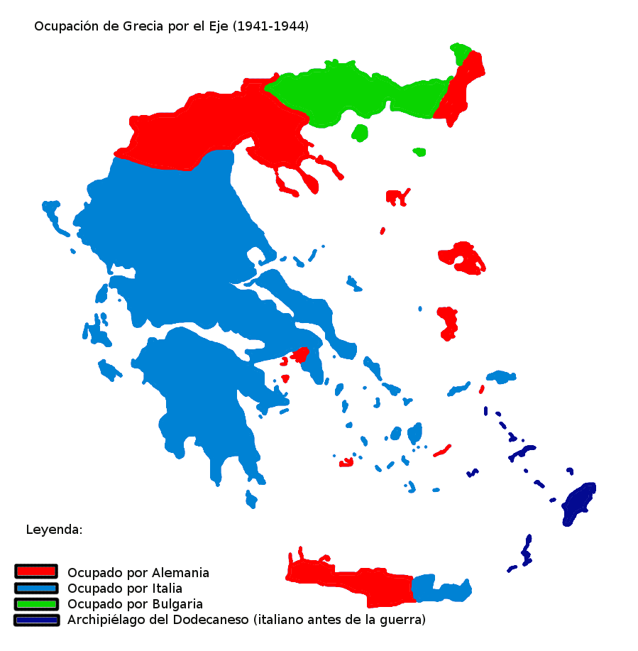
Map showning the zones of control of the three occupying powers in Greece during WW2, from 1941 to 1944. English: Map of Occupied Greece showing the German and Italian occupation zones on Crete. Svenska: Axelmakternas ockupationszoner under andra världskriget: blått Italien, grönt Bulgarien och rött Tyskland Türkçe: Üçlü işgâl sürecinde Yunanistan
Español: Mapa de las zonas de ocupación en las que se dividió Grecia durante la Segunda Guerra Mundial (1941-1944). |
| Date | (UTC) |
| Source | |
| Author |
|
| Other versions |
[]
|


_-fr.png)


| This is a retouched picture, which means that it has been digitally altered from its original version. Modifications: Spanish version. The original can be viewed here: Gr-triple-occupation.png:
|
I, the copyright holder of this work, hereby publish it under the following licenses:
| This file is licensed under the Creative Commons Attribution-Share Alike 3.0 Unported license. | ||
| ||
| This licensing tag was added to this file as part of the GFDL licensing update. |

|
Permission is granted to copy, distribute and/or modify this document under the terms of the GNU Free Documentation License, Version 1.2 or any later version published by the Free Software Foundation; with no Invariant Sections, no Front-Cover Texts, and no Back-Cover Texts. A copy of the license is included in the section entitled GNU Free Documentation License. |
You may select the license of your choice.
Original upload log[edit]
This image is a derivative work of the following images:
- File:Gr-triple-occupation.png licensed with Cc-by-sa-3.0-migrated, GFDL
- 2006-05-22T15:48:03Z GhePeU 899x917 (83492 Bytes) slightly reworked image
- 2005-07-02T16:06:06Z Michalis Famelis 899x917 (109852 Bytes) Map showning the zones of control of the three occupying powers in Greece during WW2, from 1941 to 1944. The image was created by me using another map as a template. This image was created using the Gimp. {{GFDL}}
Uploaded with derivativeFX
File history
Click on a date/time to view the file as it appeared at that time.
| Date/Time | Thumbnail | Dimensions | User | Comment | |
|---|---|---|---|---|---|
| current | 19:11, 27 January 2010 | | 899 × 917 (81 KB) | Rowanwindwhistler (talk | contribs) | {{Information |Description=Map showning the zones of control of the three occupying powers in Greece during WW2, from 1941 to 1944. {{en|Map of Occupied Greece showing the German and Italian occupation zones on Crete.}} {{sv|Axelmakternas ockupationszoner |
You cannot overwrite this file.
File usage on Commons
The following 15 pages use this file:
- File:Gr-triple-occupation-ES.png
- File:Gr-triple-occupation-gr.png
- File:Gr-triple-occupation-Česky.JPG
- File:Gr-triple-occupation.png
- File:Occupation-de-la-grece-he.png
- File:Occupation de la grece (1941-1944) -fr.png
- File:PL-triple-occupation.png
- File:Tripla occupazione greca.gif
- File:Triple Occupation of Greece.png
- File:Triple occupation of Greece-zh.svg
- File:Triple occupation of Greece de.svg
- File:Triple occupation of Greece el.svg
- File:Triple occupation of Greece es.svg
- File:Triple occupation of Greece mk.svg
- Template:Other versions/Occupation of Greece
File usage on other wikis
The following other wikis use this file:
- Usage on gl.wikipedia.org