File:Grab des nacht.png
Jump to navigation
Jump to search

Size of this preview: 800 × 551 pixels. Other resolutions: 320 × 221 pixels | 640 × 441 pixels | 1,024 × 706 pixels | 1,280 × 882 pixels | 1,998 × 1,377 pixels.
Original file (1,998 × 1,377 pixels, file size: 267 KB, MIME type: image/png)
Captions
Captions
Add a one-line explanation of what this file represents
Summary
[edit]
| Description |
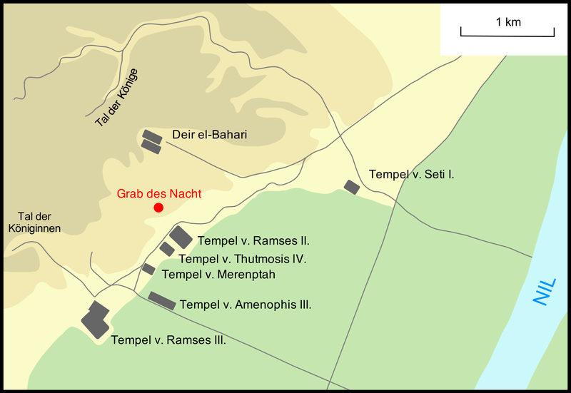
Deutsch: Karte zur Veranschaulichung der Lage des Grabs von Nacht |
| Date | |
| Source | Google Earth, http://www.luxor-westbank.com/bilder/karten/map_theban_sites_d.jpg, |
| Author | c.lingg 17:59, 28. Jul. 2007 (CEST) |
| Remarks | Deutsch: noch nicht fertiggestellt, zur Diskussion hochgeladen |
Licensing
[edit]
This file is licensed under the Creative Commons Attribution-Share Alike 2.0 Germany license.
- You are free:
- to share – to copy, distribute and transmit the work
- to remix – to adapt the work
- Under the following conditions:
- attribution – You must give appropriate credit, provide a link to the license, and indicate if changes were made. You may do so in any reasonable manner, but not in any way that suggests the licensor endorses you or your use.
- share alike – If you remix, transform, or build upon the material, you must distribute your contributions under the same or compatible license as the original.

Original upload log
[edit]
Transferred from de.wikipedia to Commons by Wdwdbot using script bot_filetrans.pl (r85M).
The original description page was here. All following user names refer to de.wikipedia.
- 2007-09-18 07:36:52 C.lingg (273422 Bytes) Beschriftungen sind näher am Objekt
- 2007-08-16 22:47:04 C.lingg (270115 Bytes) {{Information |Beschreibung = |Quelle = |Urheber = |Datum = |Genehmigung = |Andere Versionen = |Anmerkungen = }}
- 2007-08-12 08:50:34 C.lingg (198962 Bytes) {{Information |Beschreibung = |Quelle = |Urheber = |Datum = |Genehmigung = |Andere Versionen = |Anmerkungen = }}
- 2007-08-12 08:41:16 C.lingg (198567 Bytes) {{Information |Beschreibung = |Quelle = |Urheber = |Datum = |Genehmigung = |Andere Versionen = |Anmerkungen = }}
- 2007-08-09 17:30:57 C.lingg (209995 Bytes) {{Information |Beschreibung = |Quelle = |Urheber = |Datum = |Genehmigung = |Andere Versionen = |Anmerkungen = Anregungen aus der Diskussion in der Kartenwerkstatt eingearbeitet }}
- 2007-07-28 15:59:11 C.lingg (134878 Bytes) {{Information |Beschreibung = Karte zur Veranschaulichung der Lage des Grabs von Nacht |Quelle = Google Earth, http://www.luxor-westbank.com/bilder/karten/map_theban_sites_d.jpg, |Urheber = ~~~~ |Datum = 28.07.07 |Anmerkungen = noch nicht fertig gestellt
File history
Click on a date/time to view the file as it appeared at that time.
| Date/Time | Thumbnail | Dimensions | User | Comment | |
|---|---|---|---|---|---|
| current | 20:27, 4 June 2017 | | 1,998 × 1,377 (267 KB) | Wdwdbot (talk | contribs) | Bot Move: Original uploader of this revision (#6) was C.lingg at de.wikipedia |
| 20:26, 4 June 2017 |  | 1,998 × 1,377 (264 KB) | Wdwdbot (talk | contribs) | Bot Move: Original uploader of this revision (#5) was C.lingg at de.wikipedia | |
| 20:26, 4 June 2017 |  | 1,598 × 1,102 (194 KB) | Wdwdbot (talk | contribs) | Bot Move: Original uploader of this revision (#4) was C.lingg at de.wikipedia | |
| 20:26, 4 June 2017 |  | 1,598 × 1,102 (194 KB) | Wdwdbot (talk | contribs) | Bot Move: Original uploader of this revision (#3) was C.lingg at de.wikipedia | |
| 20:25, 4 June 2017 |  | 1,598 × 1,102 (205 KB) | Wdwdbot (talk | contribs) | Bot Move: Original uploader of this revision (#2) was C.lingg at de.wikipedia | |
| 20:25, 4 June 2017 |  | 1,118 × 771 (132 KB) | Wdwdbot (talk | contribs) | Bot Move: Original uploader of this revision (#1) was C.lingg at de.wikipedia |
You cannot overwrite this file.
File usage on Commons
There are no pages that use this file.
File usage on other wikis
The following other wikis use this file:
- Usage on de.wikipedia.org