File:Grande Terre New Caledonia (MODIS 2020-07-24).jpg

Original file (2,744 × 2,357 pixels, file size: 605 KB, MIME type: image/jpeg)
Captions
Captions
Summary
[edit].jpg&action=edit§ion=1)
| Description |
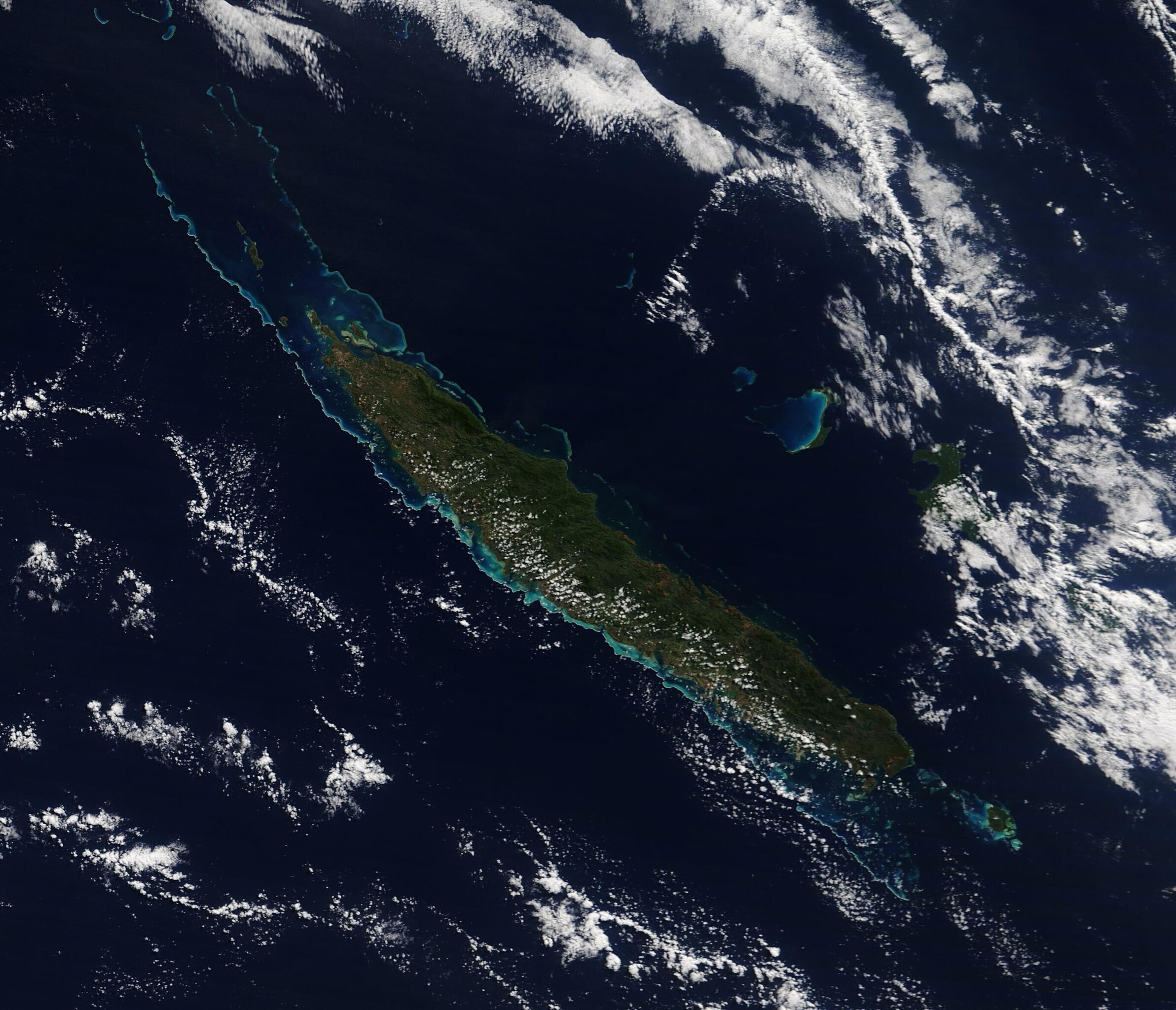
English: On July 16, 2020, the Moderate Resolution Imaging Spectroradiometer (MODIS) on board NASA’s Terra satellite acquired a true-color image of the island of Grande Terre, New Caledonia.
A long line of coral reef, shining in iridescent blues and greens ring much of the long green island. These reefs are rich in biodiversity, with the northwestern section alone housing more than 300 species of coral fauna counted here, as of a count performed in 2008. Grand Terre lies about 830 miles (1,300 km) east of Australia and sits in the Coral Sea. The island is roughly 400 kilometers (250 miles) long and ringed by a 1,600-kilometer (1,000-mile) coral reef. It is the largest island of New Caledonia, which also contains the Loyalty Islands, the Chesterfield Islands, the Belep archipelago and the Isle of Pines as well as a number of islets. The climate of New Caledonia is generally hot and humid, but the trade winds bring relatively cool, moist air to the eastern part of the island, where rich forests fill the coastal strip between the mountainous interior and the sea. The tallest point is Mont Panié with an elevation of 1,628 meters (5,341 feet) above sea level. The mountains form a rain shadow in the west, giving rise to low, open, arid plains. New Caledonia’s rocks are unusually rich in iron, magnesium, and nickel; in fact, the island is home to about a quarter of the world’s known nickel resources. Meanwhile the soils are poor in nitrogen, calcium, phosphorus, and potassium, and plant life has had to adapt. About 75 percent of New Caledonia’s plant species are found only the island, placing New Caledonia third, after Hawaii and New Zealand, for endemic plant species. Marine life around New Caledonia rivals the unique plant life. The United Nations Educational, Scientific and Cultural Organization (UNESCO) characterizes the reef system as “the world’s most diverse concentration of reef structures.” The reef, mangrove, and seagrass habitats provide homes to fish, marine invertebrates, marine mammals (such as whales and dugongs), and turtles. |
||
| Date | Taken on 16 July 2020 | ||
| Source |
Grande Terre New Caledonia (direct link)
|
||
| Author | MODIS Land Rapid Response Team, NASA GSFC |
| This media is a product of the Terra mission Credit and attribution belongs to the mission team, if not already specified in the "author" row |
Licensing
[edit].jpg&action=edit§ion=2)
| This file is in the public domain in the United States because it was solely created by NASA. NASA copyright policy states that "NASA material is not protected by copyright unless noted". (See Template:PD-USGov, NASA copyright policy page or JPL Image Use Policy.) | ||
 |
Warnings:
|
File history
Click on a date/time to view the file as it appeared at that time.
| Date/Time | Thumbnail | Dimensions | User | Comment | |
|---|---|---|---|---|---|
| current | 02:57, 17 February 2024 | | 2,744 × 2,357 (605 KB) | OptimusPrimeBot (talk | contribs) | #Spacemedia - Upload of http://modis.gsfc.nasa.gov/gallery/images/image07242020_250m.jpg via Commons:Spacemedia |
You cannot overwrite this file.
File usage on Commons
There are no pages that use this file.
.jpg&oldid=852747335)