File:Great Lakes 1913 Storm Shipwrecks.png

Fichier d’origine (4 000 × 2 400 pixels, taille du fichier : 799 kio, type MIME : image/png)
Légendes
Légendes
Description[modifier]
| Description |
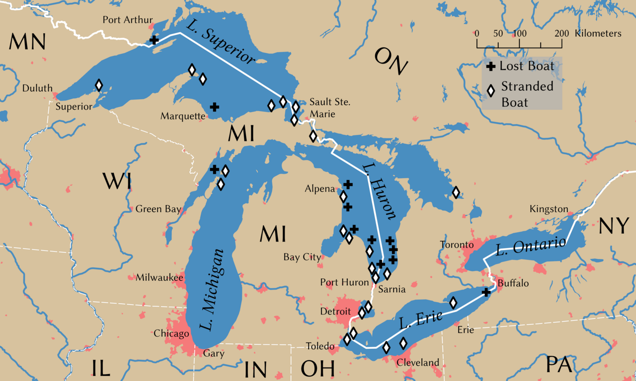
English: Shipwrecks during the Great Lakes Storm of 1913. Wreck locations come from Brown (2002, p. 203) |
||
| Date | |||
| Source | Travail personnel | ||
| Créé par | |||
| Attribution de l’acquisition | © Tom Fish, geo.fish // Creative Commons BY-SA 4.0 | ||
| Autorisation (Réutilisation de ce fichier) |
|
||
| Données géotemporelles | |||
| Système de coordonnées | NAD 1983 Great Lakes Basin Albers [WKID: 31734] | ||
| Échelle | 1:11,792,324 | ||
| Données d'archives | |||
| artwork-references | Brown, David G. (2002) White Hurricane: A Great Lakes November Gale and America's Deadliest Maritime Disaster, International Marine/McGraw-Hill ISBN : 0-07-138037-X. | ||
| PNG information | Cette carte a été créée avec ArcGIS Pro |
||
Conditions d’utilisation[modifier]
Data[modifier]
Rivers, lakes, and urban areas[modifier]
| This file uses data that was sourced from Natural Earth, a public domain dataset. From the terms of use:
All versions of Natural Earth raster + vector map data found on this website are in the public domain. You may use the maps in any manner, including modifying the content and design, electronic dissemination, and offset printing. The primary authors, Tom Patterson and Nathaniel Vaughn Kelso, and all other contributors renounce all financial claim to the maps and invites you to use them for personal, educational, and commercial purposes. |
Shipwreck locations[modifier]
The locations of the shipwrecks are facts and are not eligible for copyright protection
| Ce document n'est pas soumis au droit d'auteur et est donc dans le domaine public, car il est composé exclusivement d'informations qui sont dans le domaine public et ne contient aucune modification qui en ferait une œuvre originale. |
International boundary[modifier]
The international boundaries are sourced from the Large Scale International Boundaries published by the US Department of State
| This image is a work of a United States Department of State employee, taken or made as part of that person's official duties. As a work of the U.S. federal government, the image is in the public domain per 17 U.S.C. § 101 and § 105 and the Department Copyright Information. |  |
State boundary[modifier]
The state boundaries are sourced from STATE_BOUNDS the United States Geological Survey
Cette image est placée dans le domaine public parce qu'elle contient des éléments issus de l'United States Geological Survey, une agence du Département de l'Intérieur des États-Unis. Pour plus d'information, consultez la politique officielle de copyright de l'USGS (en anglais)
|
Final Map[modifier]
- Vous êtes libre :
- de partager – de copier, distribuer et transmettre cette œuvre
- d’adapter – de modifier cette œuvre
- Sous les conditions suivantes :
- paternité – Vous devez donner les informations appropriées concernant l'auteur, fournir un lien vers la licence et indiquer si des modifications ont été faites. Vous pouvez faire cela par tout moyen raisonnable, mais en aucune façon suggérant que l’auteur vous soutient ou approuve l’utilisation que vous en faites.
- partage à l’identique – Si vous modifiez, transformez, ou vous basez sur cette œuvre, vous devez distribuer votre contribution sous la même licence ou une licence compatible avec celle de l’original.
Historique du fichier
Cliquer sur une date et heure pour voir le fichier tel qu'il était à ce moment-là.
| Date et heure | Vignette | Dimensions | Utilisateur | Commentaire | |
|---|---|---|---|---|---|
| actuel | 8 novembre 2021 à 23:54 | | 4 000 × 2 400 (799 kio) | Guerillero (d | contributions) | Remedy copyright issues |
| 27 février 2007 à 19:07 |  | 1 786 × 1 194 (1,05 Mio) | SalomonCeb (d | contributions) | Shipwrecks during the en:Great Lakes Storm of 1913. Reference: ''White Hurricane'', by David G. Brown, 2002. All text and icons were added to the PD blank map located at: http://walrus.wr.usgs.gov/infobank/gazette/jpg/regions/fr_glez.jpg {{PD-s |
Vous ne pouvez pas remplacer ce fichier.
Utilisations locales du fichier
Les 3 pages suivantes utilisent ce fichier :
Utilisations du fichier sur d’autres wikis
Les autres wikis suivants utilisent ce fichier :
- Utilisation sur ca.wikipedia.org
- Utilisation sur de.wikipedia.org
- Utilisation sur de.wiktionary.org
- Utilisation sur en.wikipedia.org
- Utilisation sur fr.wikipedia.org
- Utilisation sur nl.wikipedia.org
- Utilisation sur ru.wikipedia.org
- Utilisation sur uz.wikipedia.org