File:Greater Manchester UK locator map 2010.svg
Aller à la navigation
Aller à la recherche

Taille de cet aperçu PNG pour ce fichier SVG : 494 × 600 pixels. Autres résolutions : 198 × 240 pixels | 395 × 480 pixels | 633 × 768 pixels | 843 × 1 024 pixels | 1 687 × 2 048 pixels | 1 108 × 1 345 pixels.
Fichier d’origine (Fichier SVG, nominalement de 1 108 × 1 345 pixels, taille : 302 kio)
Légendes
Légendes
Ajoutez en une ligne la description de ce que représente ce fichier
Description
[modifier]
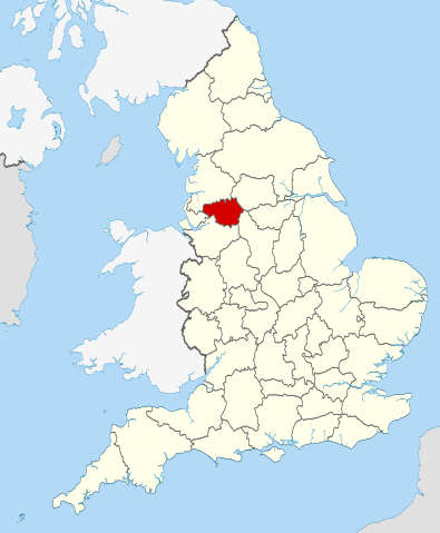
| Description | Location of the ceremonial county of Greater Manchester within England. |
| Date | |
| Source |
National Geospatial-Intelligence Agency
|
| Auteur | Nilfanion |
Conditions d’utilisation
[modifier]
Moi, en tant que détenteur des droits d’auteur sur cette œuvre, je la publie sous les licences suivantes :
Ce fichier est disponible selon les termes de la licence Creative Commons Attribution – Partage dans les Mêmes Conditions 3.0 (non transposée).
- Vous êtes libre :
- de partager – de copier, distribuer et transmettre cette œuvre
- d’adapter – de modifier cette œuvre
- Sous les conditions suivantes :
- paternité – Vous devez donner les informations appropriées concernant l'auteur, fournir un lien vers la licence et indiquer si des modifications ont été faites. Vous pouvez faire cela par tout moyen raisonnable, mais en aucune façon suggérant que l’auteur vous soutient ou approuve l’utilisation que vous en faites.
- partage à l’identique – Si vous modifiez, transformez, ou vous basez sur cette œuvre, vous devez distribuer votre contribution sous la même licence ou une licence compatible avec celle de l’original.

|
Vous avez la permission de copier, distribuer et modifier ce document selon les termes de la GNU Free Documentation License version 1.2 ou toute version ultérieure publiée par la Free Software Foundation, sans sections inaltérables, sans texte de première page de couverture et sans texte de dernière page de couverture. Un exemplaire de la licence est inclus dans la section intitulée GNU Free Documentation License. |
Vous pouvez choisir l’une de ces licences.

|
Ceci est une des images constituant une partie de l'ensemble d'images de valeur : Locator maps of the Ceremonial counties of England, sur Wikimedia Commons. Le groupe d'images a été validé selon les critères pour les ensembles d'images de valeur et a été considéré comme étant l'ensemble possédant la plus grande valeur sur Commons dans la thématique :
Locator maps of the Ceremonial counties of England
Vous pouvez consulter la proposition sur Commons:Valued image candidates/Locator maps of English ceremonial counties. |
Historique du fichier
Cliquer sur une date et heure pour voir le fichier tel qu'il était à ce moment-là.
| Date et heure | Vignette | Dimensions | Utilisateur | Commentaire | |
|---|---|---|---|---|---|
| actuel | 23 novembre 2010 à 22:37 | | 1 108 × 1 345 (302 kio) | Nilfanion (d | contributions) | == Summary == {{Information |Description=Location of the ceremonial county of Greater Manchester within England. |Source=Ordnance Survey [https://www.ordnancesurvey.co.uk/opendatadownload/products.html OpenDa |
Vous ne pouvez pas remplacer ce fichier.
Utilisations locales du fichier
Les 49 pages suivantes utilisent ce fichier :
- Greater Manchester
- Manchester
- Valued image set: Locator maps of the Ceremonial counties of England
- User:Cnbrb/sandbox
- Commons:Valued image candidates/Locator maps of English ceremonial counties
- Category:Alumni by school in Greater Manchester
- Category:Association football in Greater Manchester
- Category:Bridges in Greater Manchester
- Category:Bus stations in Greater Manchester
- Category:Canals in Greater Manchester
- Category:Castles in Greater Manchester
- Category:Cemeteries in Greater Manchester
- Category:Companies in Greater Manchester
- Category:Deaths in Greater Manchester
- Category:Greater Manchester
- Category:Greater Manchester Combined Authority
- Category:Greater Manchester in the 1900s
- Category:Greater Manchester in the 1910s
- Category:Greater Manchester in the 1920s
- Category:Greater Manchester in the 1930s
- Category:Greater Manchester in the 1940s
- Category:Greater Manchester in the 1950s
- Category:Greater Manchester in the 1960s
- Category:Greater Manchester in the 1970s
- Category:Greater Manchester in the 1980s
- Category:Greater Manchester in the 1990s
- Category:Greater Manchester in the 2000s
- Category:Greater Manchester in the 2010s
- Category:Greater Manchester in the 2020s
- Category:Greater Manchester in the 20th century
- Category:Greater Manchester in the 21st century
- Category:Hospitals in Greater Manchester
- Category:Local government in Greater Manchester
- Category:Maps of Greater Manchester
- Category:People of Greater Manchester
- Category:Politics of Greater Manchester
- Category:Populated places in Greater Manchester
- Category:Rail transport in Greater Manchester
- Category:Rivers of Greater Manchester
- Category:Roads in Greater Manchester
- Category:Sports in Greater Manchester
- Category:Sports venues in Greater Manchester
- Category:Towers in Greater Manchester
- Category:Transport in Greater Manchester
- Category:Tunnels in Greater Manchester
- Category:Unparished areas in Greater Manchester
- Category:Views of Greater Manchester
- Category:Villages in Greater Manchester
- Category:Visitor attractions in Greater Manchester
Utilisations du fichier sur d’autres wikis
Les autres wikis suivants utilisent ce fichier :
- Utilisation sur af.wikipedia.org
- Utilisation sur an.wikipedia.org
- Utilisation sur ar.wikipedia.org
- Utilisation sur arz.wikipedia.org
- Utilisation sur ast.wikipedia.org
- Utilisation sur be-tarask.wikipedia.org
- Utilisation sur be.wikipedia.org
- Utilisation sur bg.wikipedia.org
- Utilisation sur bn.wikipedia.org
- Utilisation sur br.wikipedia.org
- Utilisation sur ca.wikipedia.org
- Utilisation sur ceb.wikipedia.org
- Utilisation sur cs.wikipedia.org
- Utilisation sur en.wikipedia.org
- Greater Manchester
- Egerton, Greater Manchester
- Etherow Country Park
- River Bollin
- River Croal
- Parrs Wood
- Transport for Greater Manchester
- Friezland
- Strinesdale Reservoir
- Moorside, Greater Manchester
- Heald Green
- Bryn, Greater Manchester
- Three Sisters Recreation Area
- Peel Green
- Audenshaw Reservoirs
- Offerton, Greater Manchester
- Gorton North
- Carrbrook
- Ancoats and Clayton
- Adswood
- Turf Lea
- Hawk Green
- Template:GreaterManchester-geo-stub
- Bosden Farm
- Talk:Greater Manchester Passenger Transport Executive
- Makerfield
- Exchange Square, Manchester
- Old Moat
- Worthington, Greater Manchester
- Prestolee
- Copley, Greater Manchester
- Benchill
- Standish-with-Langtree
- Bucklow Rural District
- Bury Rural District
Voir davantage sur l’utilisation globale de ce fichier.