File:Greening in Mali (MODIS 2021-11-18).jpg

Original file (1,508 × 1,201 pixels, file size: 919 KB, MIME type: image/jpeg)
Captions
Captions
Summary
[edit].jpg&action=edit§ion=1)
| Description |
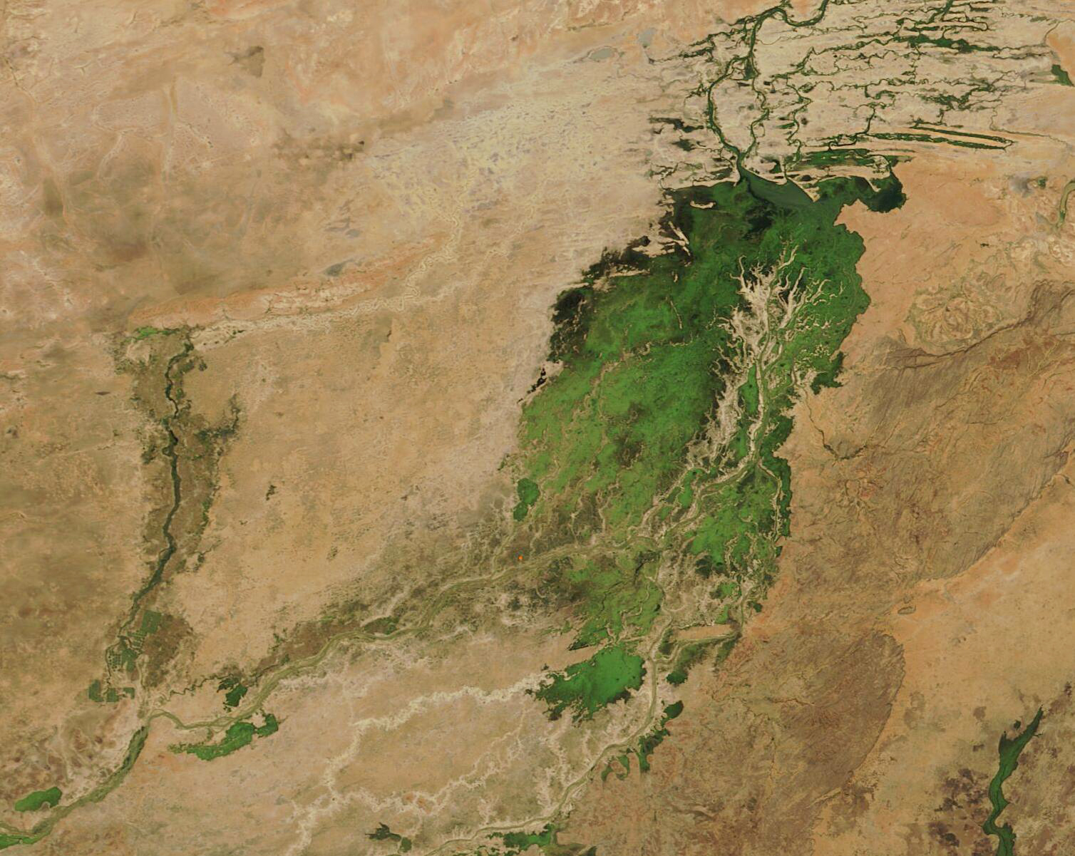
English: Spanning an area a little larger than twice the size of the U.S. state of Texas, the land-locked African country of Mali sits on the edge of both the Sahara Desert and the African Sahel. The hot, dry climate leaves little arable land, especially in the desert north. The Sahel, located mostly in the south, has a slightly gentler climate than the north, with the hot and dry season (February to June) giving way to a warm rainy season (June to early November) and then a cooler dry season.
The rainy season fills the Niger River, the Bani River, and several streams, which all come together at the Inland Niger Delta, creating a heartland of brilliant green in southern Mali. During the dry season, the Inland Delta shrinks dramatically to roughly about 1,500 square miles (3,900 sq. km). By November, the Delta can expand to 7,700 square miles (20,000 sq. km). This wealth of water provides a boon for people, and excellent habitat for migrating birds and West African manatees. As waters recede, the fertile floodplains provide excellent agricultural land, ripe for rice or pasture. On November 17, 2021, The Moderate Resolution Imaging Spectroradiometer (MODIS) on board NASA’s Terra satellite acquired a true-color image of the gorgeous greening of the Inland Niger Delta. The complex arrangement of river channels, lakes, and swamps are evident. The tree-like, branching tan area is actually an area of higher elevation, which remains dry. Wherever water seeps, especially close to the rivers, the arid, tan land has burst forth in green. Away from the rivers, a faint wash of green sits atop the tans that mark near-desert conditions, representing the tenacity of plants to grow when given even a little rain. |
||
| Date | Taken on 17 November 2021 | ||
| Source |
Greening in Mali (direct link)
|
||
| Author | MODIS Land Rapid Response Team, NASA GSFC |
| This media is a product of the Terra mission Credit and attribution belongs to the mission team, if not already specified in the "author" row |
Licensing
[edit].jpg&action=edit§ion=2)
| This file is in the public domain in the United States because it was solely created by NASA. NASA copyright policy states that "NASA material is not protected by copyright unless noted". (See Template:PD-USGov, NASA copyright policy page or JPL Image Use Policy.) | ||
 |
Warnings:
|
File history
Click on a date/time to view the file as it appeared at that time.
| Date/Time | Thumbnail | Dimensions | User | Comment | |
|---|---|---|---|---|---|
| current | 14:25, 20 January 2024 | | 1,508 × 1,201 (919 KB) | OptimusPrimeBot (talk | contribs) | #Spacemedia - Upload of http://modis.gsfc.nasa.gov/gallery/images/image11182021_250m.jpg via Commons:Spacemedia |
You cannot overwrite this file.
File usage on Commons
There are no pages that use this file.
.jpg&oldid=880798206)