File:Greenland.A2003233.1340.250m.jpg
Jump to navigation
Jump to search
Size of this preview: 450 × 600 pixels. Other resolutions: 180 × 240 pixels | 360 × 480 pixels | 576 × 768 pixels | 768 × 1,024 pixels | 2,400 × 3,200 pixels.
Original file (2,400 × 3,200 pixels, file size: 1.85 MB, MIME type: image/jpeg)
Captions
Captions
Add a one-line explanation of what this file represents
|
Summary
[edit]| Description |
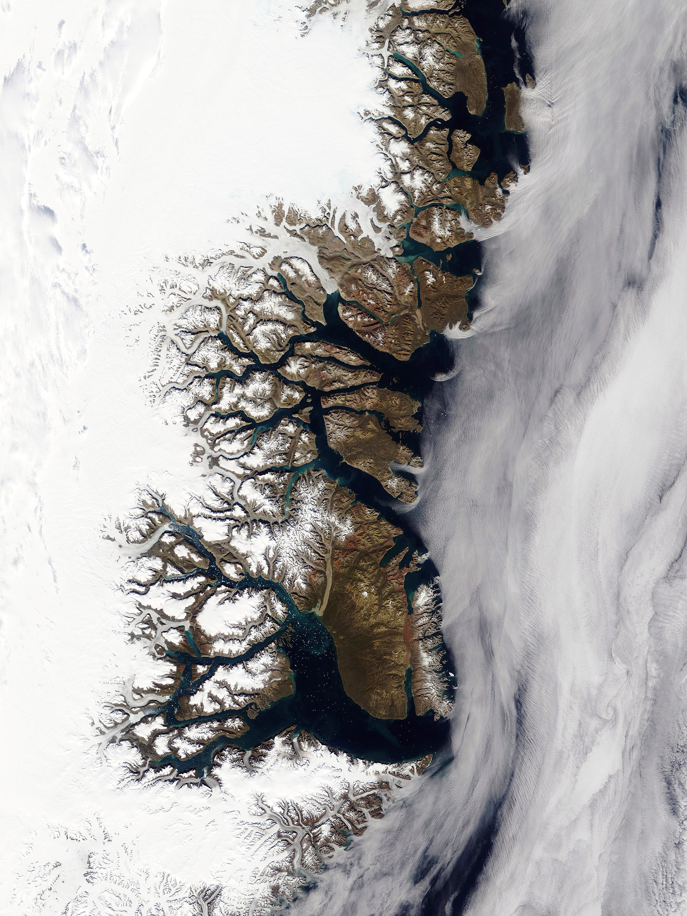
English: Greenland’s eastern coast is featured in this true-color Terra MODIS image from August 21, 2003. In the image, snows have yet to cover the coastal lands, and the waters in the fjords show spots of bright turquoise color from sediments deposited there by runoff. In the higher-resolution images, little spots of white in the water seem to be ice originating from the deeper fjords that reach all the way to the icecap covering most of the island.
Українська: Супутниковий знімок східного узбережжя Гренландії, від 21 серпня 2003 року. Прибережні скелі вільні від снігового покриву, бірюзовий колір вод фіордів пов’язаний з осадами. Білі плями на воді — крига з льодовиків. |
|||||
| Date | ||||||
| Source | http://visibleearth.nasa.gov/view_rec.php?id=5982 | |||||
| Author | NASA | |||||
| Permission (Reusing this file) |
|
|||||
| Other versions |


File history
Click on a date/time to view the file as it appeared at that time.
| Date/Time | Thumbnail | Dimensions | User | Comment | |
|---|---|---|---|---|---|
| current | 14:01, 6 November 2005 | | 2,400 × 3,200 (1.85 MB) | Brian0918 (talk | contribs) | '''en:''' Greenland’s eastern coast is featured in this true-color Terra MODIS image from August 21, 2003. In the image, snows have yet to cover the coastal lands, and the waters in the fjords show spots of bright turquoise color from sediments deposite |
You cannot overwrite this file.
File usage on Commons
The following 3 pages use this file:
File usage on other wikis
The following other wikis use this file:
- Usage on bs.wikipedia.org
- Usage on ceb.wikipedia.org
- Usage on da.wikipedia.org
- Usage on de.wikipedia.org
- Usage on el.wiktionary.org
- Usage on en.wikipedia.org
- Geography of Greenland
- Scoresby Sound
- Wikipedia:Featured pictures thumbs/03
- Wikipedia:Featured picture candidates/November-2005
- Wikipedia:Featured picture candidates/Greenland.A2003233.1340.250m.jpg
- Wikipedia:Wikipedia Signpost/2005-11-21/Features and admins
- User talk:Brian0918/Archive 14
- User talk:Brian0918/Featured gallery
- User:Cyde/Featured pictures
- Wikipedia:Picture of the day/February 2006
- Wikipedia:Picture of the day/February 28, 2006
- Wikipedia:POTD/February 28, 2006
- Wikipedia:POTD column/February 28, 2006
- Wikipedia:POTD row/February 28, 2006
- Portal:North America/Selected picture
- Portal:Maps/Selected picture
- Wikipedia:Featured pictures/Space/Looking back
- Shannon Island
- Portal:Maps/Selected picture/3
- Gauss Peninsula
- Wollaston Foreland
- Portal:North America/Selected picture/22
- Gael Hamke Bay
- Isfjord
- Wordie Glacier
- Loch Fyne (Greenland)
- Godthab Gulf
- Wordie Bay (Greenland)
- Young Sound
- Lindeman Fjord
- Fligely Fjord
- Tyrolerfjord
- Norlund Alps
- Dickson Fjord
- Grandjean Fjord
- Muskox Fjord
- Kjerulf Fjord
- Wikipedia:Wikipedia Signpost/Single/2005-11-21
- Usage on es.wikipedia.org
- Usage on fa.wikipedia.org
View more global usage of this file.