File:Grensekart nr. 21.tiff

Original file (41,143 × 16,548 pixels, file size: 1.38 GB, MIME type: image/tiff)
Captions
Captions
Summary[edit]
| Warning | The original file is very high-resolution. It might not load properly or could cause your browser to freeze when opened at full size. |
|---|
| Description |
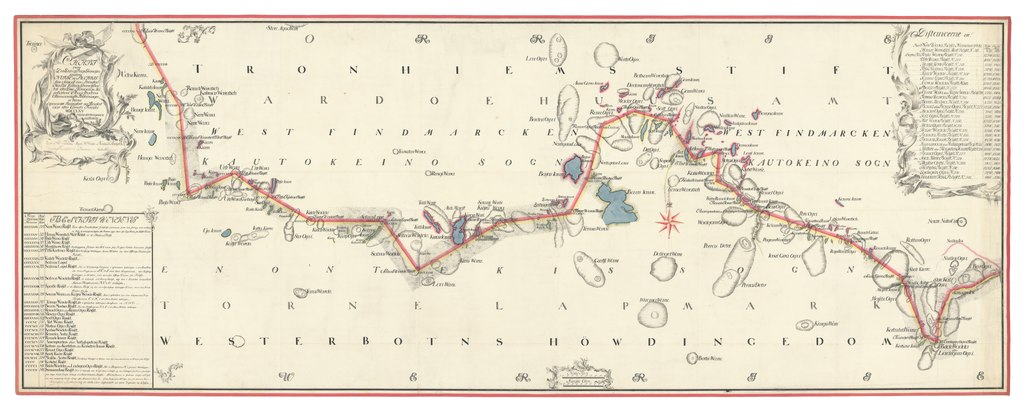
Norsk bokmål: Grensekart nr. 21 viser området nærmest grensen i deler av Kautokeino prestegjeld. Det er tegnet i 1765 og måler hele 130x331 cm. Riksarkivet, Kart- og tegningssamlingen, GA 21.
English: Border map no. 21 shows the area nearest the border in parts of Kautokeino parish. It was drawn in 1765, and measures 130×331 cm.
Davvisámegiella: Kárta čájeha riikaráji mii sárgojuvvui gaskkal Dánmárkku – Norgga ja Ruoŧŧa (dál Suoma) Guovdageainnu girkosuohkana. Dat sárgojuvvui boađusin Strømstad- traktáhtas masa Lappekodisilla lea mielddusin. |
|||||||||||||||||||||||
| Date | ||||||||||||||||||||||||
| Source |
https://media.digitalarkivet.no/view/165465/1
|
|||||||||||||||||||||||
| Author | Unknown author | |||||||||||||||||||||||
| Other versions | ||||||||||||||||||||||||

Licensing[edit]
| This image is in the public domain in Norway because images considered to be "works of art" become public domain 70 years after the author's death or 70 years after publication if the author is anonymous.
This is according to § 11 and § 12 in the Norwegian Åndsverkloven. To uploader: Please provide information about where the image was first published, who created it, and when the creator died, if known. The right to be attributed does not expire in Norway.
Images uploaded to Wikimedia Commons must also be in the public domain in the United States. A Norwegian work that is in the public domain in Norway is in the public domain in the U.S. only if (a) it was in the public domain in Norway in 1996, e.g. if a photo was created before January 1, 1946 and no copyright was registered in the U.S. (This is the effect of 17 USC 104A with its critical date of January 1, 1996.) or (b) if it was created more than 95 years ago.
|
 |
File history
Click on a date/time to view the file as it appeared at that time.
| Date/Time | Thumbnail | Dimensions | User | Comment | |
|---|---|---|---|---|---|
| current | 08:55, 1 November 2021 | 41,143 × 16,548 (1.38 GB) | Jon Harald Søby (WMNO) (talk | contribs) | c:User:Rillke/bigChunkedUpload.js: Grensekart nr. 21. {{PD-old}} |
You cannot overwrite this file.
File usage on Commons
The following 2 pages use this file: