File:Grenzstein 17 KP KS.jpg
Jump to navigation
Jump to search

Size of this preview: 800 × 525 pixels. Other resolutions: 320 × 210 pixels | 640 × 420 pixels | 1,024 × 672 pixels | 1,280 × 840 pixels | 2,560 × 1,679 pixels | 3,500 × 2,296 pixels.
Original file (3,500 × 2,296 pixels, file size: 1.22 MB, MIME type: image/jpeg)
Captions
Captions
Add a one-line explanation of what this file represents
Summary
[edit]
| Description |
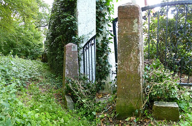
Deutsch: Grenzstein Nr. 17 Historische Landesgrenze Königreich Sachsen Königreich Preußen 1815 (Wiener Kongress) in Belgern-Schildau OT Sitzenroda
Bemerkung : Der Grenzstein ist durch Efeubewuchs meist gut getarnt. In zirka 225m Entfernung stand früher, unmittelbar an der S24, der Grenzstein Nummer 18. Dieser Grenzstein soll ausgegraben und zur Schule von Sitzenroda verbracht worden sein. Eine geplante Umnutzung als Denkmal für E. Thälmann wurde aber nicht realisiert. Dieser Grenzstein ist verschollen.
|
||
| Date | |||
| Source | Own work | ||
| Author | Radler59 |
| Camera location | | View this and other nearby images on: OpenStreetMap |
|---|
Licensing
[edit]
I, the copyright holder of this work, hereby publish it under the following license:
This file is licensed under the Creative Commons Attribution-Share Alike 3.0 Unported license.
- You are free:
- to share – to copy, distribute and transmit the work
- to remix – to adapt the work
- Under the following conditions:
- attribution – You must give appropriate credit, provide a link to the license, and indicate if changes were made. You may do so in any reasonable manner, but not in any way that suggests the licensor endorses you or your use.
- share alike – If you remix, transform, or build upon the material, you must distribute your contributions under the same or compatible license as the original.
File history
Click on a date/time to view the file as it appeared at that time.
| Date/Time | Thumbnail | Dimensions | User | Comment | |
|---|---|---|---|---|---|
| current | 21:31, 16 June 2012 | | 3,500 × 2,296 (1.22 MB) | Radler59 (talk | contribs) |
You cannot overwrite this file.
File usage on Commons
The following page uses this file:
File usage on other wikis
The following other wikis use this file:
- Usage on de.wikipedia.org
- Usage on www.wikidata.org