File:Gutiérrez, the Americas, 1562.jpg
跳转到导航
跳转到搜索

本预览的尺寸:611 × 600像素。 其他分辨率:245 × 240像素 | 489 × 480像素 | 783 × 768像素 | 1,044 × 1,024像素 | 2,087 × 2,048像素 | 5,246 × 5,148像素。
原始文件 (5,246 × 5,148像素,文件大小:16.62 MB,MIME类型:image/jpeg)
说明
说明
添加一行文字以描述该文件所表现的内容
|
摘要
[编辑]
| 描述 |
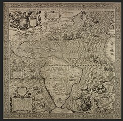
English: Map by Diego Gutiérrez showing the Spanish Empire at its height. Made for the approval of Philip II, here shown in the guise of Neptune – a relatively small figure in a seahorse-drawn chariot that is west of Florida. |
| 日期 | |
| 来源 | http://www.bl.uk/magnificentmaps/map3.html |
| 作者 | Diego Gutiérrez |
| 其他版本 |
 |
许可协议
[编辑]
|
本作品在其来源国以及其他著作权期限是作者逝世后100年或以下的国家和地区属于公有领域。 | |
| 本文件已被确认为免除已知的著作权法限制(包括所有相关权利)。 | |
| 註解 | 該圖片含有註解:在維基媒體共享資源上查看註解 |
文件历史
点击某个日期/时间查看对应时刻的文件。
| 日期/时间 | 缩略图 | 大小 | 用户 | 备注 | |
|---|---|---|---|---|---|
| 当前 | 2010年5月6日 (四) 03:31 | | 5,246 × 5,148(16.62 MB) | Mturtle(留言 | 贡献) | {{Information |Description={{en|1=Shows the Spanish Empire at its height. Made for the approval of Philip II, here shown in the guise of Neptune}} |Source=http://www.bl.uk/magnificentmaps/map3.html |Author=Diego Gutiérrez |Date=1562 |Permission= |other_v |
您不可以覆盖此文件。
文件用途
以下4个页面使用本文件:
全域文件用途
以下其他wiki使用此文件:
- ar.wikipedia.org上的用途
- el.wikipedia.org上的用途
- en.wikipedia.org上的用途
- Age of Discovery
- Wikipedia:Featured pictures/Diagrams, drawings, and maps/Maps
- Iberian cartography, 1400–1600
- User:Peter Mercator/Map gallery
- Mercator 1569 world map
- Wikipedia:Featured pictures thumbs/40
- Wikipedia:Featured picture candidates/March-2014
- Americae Sive Quartae Orbis Partis Nova Et Exactissima Descriptio
- Talk:Americae Sive Quartae Orbis Partis Nova Et Exactissima Descriptio
- Wikipedia:Featured picture candidates/Americae Sive Quartae Orbis Partis Nova Et Exactissima Descriptio
- Wikipedia:Wikipedia Signpost/2014-04-02/Featured content
- Wikipedia:Wikipedia Signpost/Single/2014-04-02
- User talk:Brandmeister/Archive 10
- Wikipedia:Picture of the day/April 2016
- Template:POTD/2016-04-27
- Wikipedia:Main Page history/2016 April 27
- User talk:Brandmeister/Archive 12
- Portal:Geography/Selected picture
- es.wikipedia.org上的用途
- fr.wikipedia.org上的用途
- hy.wikipedia.org上的用途
- it.wikipedia.org上的用途
- ms.wikipedia.org上的用途
- ru.wikipedia.org上的用途
- sl.wikipedia.org上的用途
- test.wikipedia.org上的用途
- uk.wikipedia.org上的用途
- www.wikidata.org上的用途
- zh.wikipedia.org上的用途