File:Habsburgse Nederlanden 1555.svg
Jump to navigation
Jump to search

Size of this PNG preview of this SVG file: 458 × 600 pixels. Other resolutions: 183 × 240 pixels | 366 × 480 pixels | 586 × 768 pixels | 782 × 1,024 pixels | 1,564 × 2,048 pixels | 1,651 × 2,162 pixels.
Original file (SVG file, nominally 1,651 × 2,162 pixels, file size: 871 KB)
Captions
Captions
Add a one-line explanation of what this file represents
Summary
[edit]
| Description |
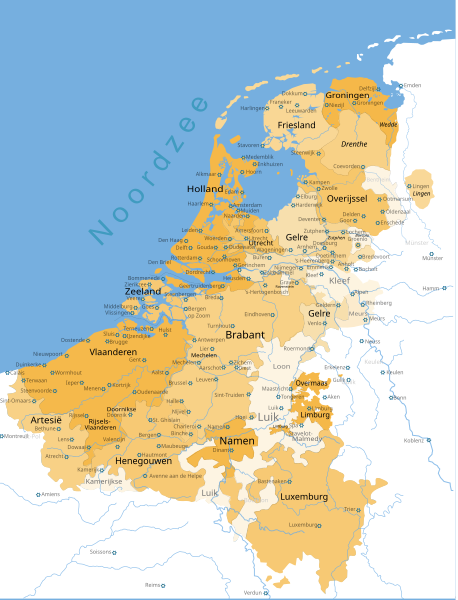
Nederlands: De Habsburgse Nederlanden in 1555 aan het eind van de regering van keizer Karel V. In deze jaren (circa 1543 tot 1585) staan de Habsburgse Nederlanden ook wel bekend als de 'Zeventien Provinciën'. Tussen 1556 en 1714 staan ze (of wat ervan onder Spaanse controle bleef tijdens en na de Tachtigjarige Oorlog) ook wel bekend als de 'Spaanse Nederlanden'; dit restant wordt van 1585 tot 1795 ook wel de 'Zuidelijke Nederlanden' genoemd.
Op 25 oktober 1555 was de telling van de Zeventien Provinciën als volgt:
Bron: Johan Rudolf Thorbecke, Robert Jacobus Fruin en Herman Theodoor Colenbrander (1922). 2. Verhouding tot het Rijk van de Zeventien Provinciën. Geschiedenis der staatsinstellingen in Nederland tot de dood van Willem II. Universiteit Leiden. Retrieved on 13 juli 2020. De 17 volwaardige leden van de Staten-Generaal zijn hier met zwarte normale letters aangegeven, de van deze 17 volwaardige leden afhankelijke gebieden zijn cursief weergegeven (bijvoorbeeld: Zutphen was ondergeschikt aan Gelre; Drenthe, Lingen en Wedde waren ondergeschikt aan Overijssel). Gebieden die geen deel uitmaakten van de Habsburgse Nederlanden, maar er wel aan grensden of er zelfs door werden omringd, zijn genoemd in grijs (bijvoorbeeld: Luik, Stavelot-Malmedy, Ravenstein, Borculo, Kleef, Bentheim, het Kamerijkse en Bouillon). |
| Date | |
| Source | File:Bourgondische Nederlanden.svg |
| Author | D'Arch, Nederlandse Leeuw |
Licensing
[edit]
This file is licensed under the Creative Commons Attribution-Share Alike 3.0 Unported license.
- You are free:
- to share – to copy, distribute and transmit the work
- to remix – to adapt the work
- Under the following conditions:
- attribution – You must give appropriate credit, provide a link to the license, and indicate if changes were made. You may do so in any reasonable manner, but not in any way that suggests the licensor endorses you or your use.
- share alike – If you remix, transform, or build upon the material, you must distribute your contributions under the same or compatible license as the original.
File history
Click on a date/time to view the file as it appeared at that time.
| Date/Time | Thumbnail | Dimensions | User | Comment | |
|---|---|---|---|---|---|
| current | 15:34, 9 March 2024 | | 1,651 × 2,162 (871 KB) | Nederlandse Leeuw (talk | contribs) | Corrected names of provinces |
| 00:17, 19 July 2020 |  | 1,651 × 2,162 (870 KB) | Cmglee (talk | contribs) | Convert ''flowRoot'' etc to ''text'' as per http://commons.wikimedia.org/wiki/Commons:Graphics_village_pump#Texts_on_map_don't_show | |
| 16:17, 13 July 2020 |  | 1,651 × 2,162 (882 KB) | Nederlandse Leeuw (talk | contribs) | Uploaded a work by D'Arch, Nederlandse Leeuw from File:Bourgondische Nederlanden.svg with UploadWizard |
You cannot overwrite this file.
File usage on Commons
The following 3 pages use this file:
File usage on other wikis
The following other wikis use this file:
- Usage on en.wikipedia.org