File:Hannover Stadtbahn Übersicht Netzteile.png
Jump to navigation
Jump to search

Size of this preview: 511 × 599 pixels. Other resolutions: 205 × 240 pixels | 409 × 480 pixels | 655 × 768 pixels | 874 × 1,024 pixels | 1,574 × 1,845 pixels.
Original file (1,574 × 1,845 pixels, file size: 1.62 MB, MIME type: image/png)
Captions
Captions
Add a one-line explanation of what this file represents
| Description |
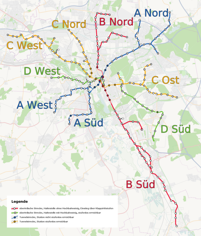
English: Light rail of Hannover, Germany. Overview
Deutsch: Stadtbahn Hannover, Übersicht Netzteile |
||||||||||||
| Date | |||||||||||||
| Source | Own work, background: OpenStreetMap data | ||||||||||||
| Author | Jeremiah21 | ||||||||||||
| Permission (Reusing this file) |
|

|
This transport map image could be re-created using vector graphics as an SVG file. This has several advantages; see Commons:Media for cleanup for more information. If an SVG form of this image is available, please upload it and afterwards replace this template with
{{vector version available|new image name}}.
It is recommended to name the SVG file “Hannover Stadtbahn Übersicht Netzteile.svg”—then the template Vector version available (or Vva) does not need the new image name parameter. |

|
This map has been made or improved in the German Kartenwerkstatt (Map Lab). You can propose maps to improve as well.
|
File history
Click on a date/time to view the file as it appeared at that time.
| Date/Time | Thumbnail | Dimensions | User | Comment | |
|---|---|---|---|---|---|
| current | 23:57, 18 September 2013 | | 1,574 × 1,845 (1.62 MB) | Nixblicker (talk | contribs) | Ricklinger Straße und Hochbahnsteig Schwarzer Bär ergänzt |
| 00:13, 12 June 2013 |  | 1,574 × 1,845 (1.62 MB) | Nixblicker (talk | contribs) | Legende eingefügt | |
| 14:29, 12 December 2012 |  | 1,574 × 1,845 (1.66 MB) | Nixblicker (talk | contribs) | {{{Aktualisierung: Neuer Hochbahnsteig}}} | |
| 22:01, 19 November 2012 |  | 1,574 × 1,845 (1.66 MB) | Nixblicker (talk | contribs) | Reverted to version as of 00:13, 12 October 2012 | |
| 12:34, 9 November 2012 |  | 1,574 × 1,845 (1.66 MB) | Nixblicker (talk | contribs) | Zugang Steintor-C nicht barrierefrei im Sinne DIN 18024. | |
| 00:13, 12 October 2012 |  | 1,574 × 1,845 (1.66 MB) | Nixblicker (talk | contribs) | Aktualisierung: Neue Hochbahnsteige | |
| 22:33, 3 January 2012 |  | 1,574 × 1,845 (1.66 MB) | Nixblicker (talk | contribs) | Lage einiger Stationen korrigiert | |
| 18:34, 27 December 2011 |  | 1,574 × 1,845 (1.66 MB) | Nixblicker (talk | contribs) | Aktualisierung: neue Hochbahnsteige | |
| 16:00, 21 February 2010 |  | 1,574 × 1,845 (1.74 MB) | Jeremiah21 (talk | contribs) | corr | |
| 20:11, 19 February 2010 |  | 1,574 × 1,845 (1.74 MB) | Jeremiah21 (talk | contribs) | {{Information |Description={{en|1=Light rail of Hannover, Germany. Overview}} {{de|1=Stadtbahn Hannover, Übersicht Netzteile}} |Source={{Own}}, background: OpenStreetMap data |Author={{U|Jeremiah21}} |Date=2010-02-19 |Permission={{OpenStreetMap}} |other_ |
You cannot overwrite this file.
File usage on Commons
There are no pages that use this file.