File:Hannoverhaus - Panorama Ankogel Group.jpg

Original file (9,744 × 1,664 pixels, file size: 8.53 MB, MIME type: image/jpeg)
Captions
Captions
Summary
[edit]| Description |
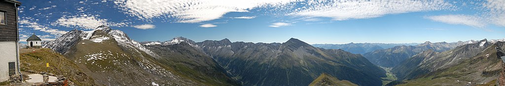
English: 180°-Panorama of the Ankogel Group, Hohe Tauern, as seen from Hannoverhaus (2719m) f.l.t.r, main direction is south. The valley down is the Seebachtal:
Hannoverhaus, Arnold-Mausoleum, Schwarzkopf (3271m), Ankogel (3252m), Kleiner Ankogel (3096m). In the foreground Grauleitenspitze (2891m) and Steinerkreuz (2772m). Oberlercherspitz (3107m), Preimlspitz (3233m), Preimlscharte (2953m), Elendköpfe (3070m), Großelendkopf (3317m, with Großelendkees in front), Hochalmspitze (3360m). Lassacher Winkelscharte (2856m), Schneewinkelspitze (3016m), Gussenbauerspitze (2981m), Säuleck (3086m), Maresenspitz (2916m), Törlkopf (2446m), Auernig (2130m). Behind that chain the Reißeckgruppe. Down in the valley is Mallnitz, in the background the Kreuzeckgruppe with Polinik (2784m). Böseck (2842m), Astromkopf (2811m), Feldseekopf (2864m), Feldseescharte (2714m), Vorderer Geißlkopf (2974m) - and in front the valley Tauerntal. At the right border: Gamskarlspitz (2833m), to the left the ridge to Liesgelespitze (2408m, in straight line with Böseck) and finally Hannoverhaus again.Deutsch: 180°-Panorama der Ankogelgruppe vom Hannoverhaus aus (2719m) v.l.n.r., Hauptrichtung Süden
Hannoverhaus, Arnold-Mausoleum, Schwarzkopf (3271m), Ankogel (3252m), Kleiner Ankogel (3096m). Im Vordergrund auf dem Kamm die Grauleitenspitze (2891m) und das Steinerkreuz (2772m). Oberlercherspitz (3107m), Preimlspitz (3233m), Preimlscharte (2953m), Elendköpfe (3070m), Großelendkopf (3317m, davor Großelendkees), Hochalmspitze (3360m). Lassacher Winkelscharte (2856m), Schneewinkelspitze (3016m), Gussenbauerspitze (2981m), Säuleck (3086m), Maresenspitz (2916m), Törlkopf (2446m), Auernig (2130m). Davor das Seebachtal. Dahinter Ochenladinspitze (2778m) und Wabnigspitze (2773m) in der Reißeckgruppe. Mallnitz, im Hintergrund die Kreuzeckgruppe mit dem Polinik (2784m). Böseck (2842m), Astromkopf (2811m), Feldseekopf (2864m), Feldseescharte (2714m), Vorderer Geißlkopf (2974m) - davor das Tauerntal. Ganz rechts Gamskarlspitz (2833m), nach links ziehend der Grat mit der Liesgelespitze (2408m, direkt vor Böseck) und wieder Hannoverhaus. This panoramic image was created with Autostitch (stitched images may differ from reality). |
| Date | |
| Source | Own work |
| Author | Herzi Pinki |
| Other versions |
_from_Hannoverhaus.jpg)
| Camera location | | View this and other nearby images on: OpenStreetMap |
|---|
Licensing
[edit]
- You are free:
- to share – to copy, distribute and transmit the work
- to remix – to adapt the work
- Under the following conditions:
- attribution – You must give appropriate credit, provide a link to the license, and indicate if changes were made. You may do so in any reasonable manner, but not in any way that suggests the licensor endorses you or your use.
- share alike – If you remix, transform, or build upon the material, you must distribute your contributions under the same or compatible license as the original.

|
Permission is granted to copy, distribute and/or modify this document under the terms of the GNU Free Documentation License, Version 1.2 or any later version published by the Free Software Foundation; with no Invariant Sections, no Front-Cover Texts, and no Back-Cover Texts. A copy of the license is included in the section entitled GNU Free Documentation License. |
File history
Click on a date/time to view the file as it appeared at that time.
| Date/Time | Thumbnail | Dimensions | User | Comment | |
|---|---|---|---|---|---|
| current | 02:52, 6 January 2009 | 9,744 × 1,664 (8.53 MB) | Herzi Pinki (talk | contribs) | {{Information |Description={{en|1=180°-Panorama of the Ankogel Group, Hohe Tauern, as seen from Hannoverhaus (2719m) f.l.t.r, main direction is south. The valley down is the Seebachtal: Hannoverhaus, Arnold-Mausoleum, Schwarzkopf (3271m), Ankogel (3252m |
You cannot overwrite this file.
File usage on Commons
The following page uses this file:
File usage on other wikis
The following other wikis use this file:
- Usage on de.wikivoyage.org
Metadata
This file contains additional information such as Exif metadata which may have been added by the digital camera, scanner, or software program used to create or digitize it. If the file has been modified from its original state, some details such as the timestamp may not fully reflect those of the original file. The timestamp is only as accurate as the clock in the camera, and it may be completely wrong.
| City shown | Hannover Hütte | ||||
|---|---|---|---|---|---|
| Image title | v.l.: Hannoverhaus, Arnold-Mausoleum, Schwarzkopf (3271m), Ankogel (3252m), Kleiner Ankogel (3096m). Im Vordergrund auf dem Kamm die Grauleitenspitze (2891m) und das Steinerkreuz (2772m).
Oberlercherspitz (3107m), Preimlspitz (3233m), Preimlscharte (2953m), Elendköpfe (3070m), Großelendkopf (3317m, davor Großelendkees), Hochalmspitze (3360m). Lassacher Winkelscharte (2856m), Schneewinkelspitze (3016m), Gussenbauerspitze (2981m), Säuleck (3086m), Maresenspitz (2916m), Törlkopf (2446m), Auernig (2130m).
Davor das Seebachtal.
Dahinter Ochenladinspitze (2778m) und Wabnigspitze (2773m) in der Reißeckgruppe.
Mallnitz, im Hintergrund die Kreuzeckgruppe mit dem Polinik (2784m).
Böseck (2842m), Astromkopf (2811m), Feldseekopf (2864m), Feldseescharte (2714m), Vorderer Geißlkopf (2974m) - davor das Tauerntal.
Ganz rechts Gamskarlspitz (2833m), nach links ziehend der Grat mit der Liesgelespitze (2408m, direkt vor Böseck) und wieder Hannoverhaus.
| ||||
| Short title | Hannoverhaus Pano nach O | ||||
| Province or state shown | Kärnten | ||||
| Keywords |
|