File:Harta 3D pentru Bazinul Raului Curpanu si Cotii, afluenti ai Oltului.jpg
Jump to navigation
Jump to search

Size of this preview: 800 × 600 pixels. Other resolutions: 320 × 240 pixels | 640 × 480 pixels | 1,024 × 768 pixels | 1,280 × 960 pixels | 1,400 × 1,050 pixels.
Original file (1,400 × 1,050 pixels, file size: 899 KB, MIME type: image/jpeg)
Captions
Captions
Add a one-line explanation of what this file represents
Summary
[edit]| Description |
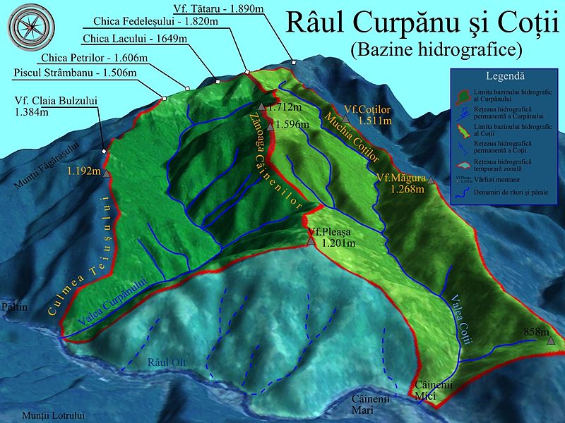
Română: Harta 3D pentru Bazinul Râului Curpănu şi Coţii, afluenţi ai Oltului. Selectați alte bazine hidrografice adiacente ale Defileului Oltului, menționate pe hartă în mod senzitiv cu chenare de note informative. |
| Date | |
| Source |
|
| Author | Asybaris01 |
| Other versions |
|

Clickable map of the (ro:Defileul Oltului)/(en:Defile Olt) drainage basin
[edit]
Licensing
[edit]| This image is in the public domain because it is a screenshot from NASA’s globe software World Wind using a public domain layer, such as Blue Marble, MODIS, Landsat, SRTM, USGS or GLOBE.
|
 |
| Annotations | This image is annotated: View the annotations at Commons |


File history
Click on a date/time to view the file as it appeared at that time.
| Date/Time | Thumbnail | Dimensions | User | Comment | |
|---|---|---|---|---|---|
| current | 07:11, 2 November 2011 | | 1,400 × 1,050 (899 KB) | Asybaris01 (talk | contribs) | {{Information |Description ={{ro|1=Harta 3D pentru Bazinul Raului Curpanu si Cotii, afluenti ai Oltului.}} |Source =Topographic data SRTM from NASA and World Imagery - NASA World Wind & 3Dem & Inkscape |Author =[[User:Asybaris01|Asybari |
You cannot overwrite this file.
File usage on Commons
The following 4 pages use this file:
- File:Harta 3D pentru Bazinul Valea lui Vlad, afluent al Oltului.jpg
- File:Harta 3D pentru Bazinul hidrografic al Raului Boia, afluent al Oltului.jpg
- File:Harta 3D pentru bazinele Vaii Boului si a Fratelui, afluenti ai Oltului.jpg
- File:Modelare 3D pentru Bazinul Raului Curpanul si Cotii, afluenti ai Oltului.gif
File usage on other wikis
The following other wikis use this file:
- Usage on en.wikipedia.org
- Usage on ja.wikipedia.org
- Usage on ro.wikipedia.org