File:Harz map topography.png
Jump to navigation
Jump to search

Size of this preview: 800 × 482 pixels. Other resolutions: 320 × 193 pixels | 640 × 385 pixels | 1,024 × 617 pixels | 1,280 × 771 pixels | 2,491 × 1,500 pixels.
Original file (2,491 × 1,500 pixels, file size: 1.83 MB, MIME type: image/png)
Captions
Captions
Add a one-line explanation of what this file represents
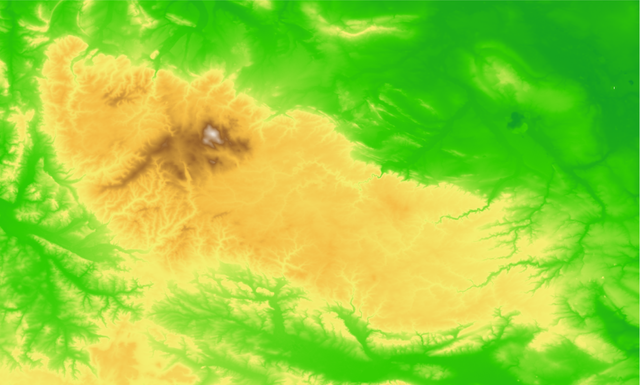
| Description | Topographic map of the w:Harz mountains in Germany. |
| Date | |
| Source |
self-made using GMT and the SRTM3 data. The commands were: grdimage harz.grd -Charz.cpt -JM25c -R10.1/51.42/11.65/52r -P -K --PAPER_MEDIA=A3+ > Harz_map_topography.ps pscoast -JM25c -R10.1/51.42/11.65/52r -W0.5/40/40/120 -I1/2/40/40/120 -I2/1/40/40/120 -I3 -N1/3/255/255/255 -Df -P -O --PAPER_MEDIA=A3+ >> Harz_map_topography.ps and #harz.cpt # 0 0 132 53 30 10 146 42 30 10 146 42 60 20 161 32 60 20 161 32 90 31 175 21 90 31 175 21 120 41 190 11 120 41 190 11 150 51 204 0 150 51 204 0 180 90 211 23 180 90 211 23 210 128 218 45 210 128 218 45 240 167 226 68 240 167 226 68 270 205 233 90 270 205 233 90 300 244 240 113 300 244 240 113 330 244 235 109 330 244 235 109 360 244 230 104 360 244 230 104 390 244 225 100 390 244 225 100 420 244 220 95 420 244 220 95 450 244 214 91 450 244 214 91 480 244 209 87 480 244 209 87 510 244 204 82 510 244 204 82 540 244 199 78 540 244 199 78 570 244 194 73 570 244 194 73 600 244 189 69 600 244 189 69 630 235 180 66 630 235 180 66 660 226 171 64 660 226 171 64 690 217 162 61 690 217 162 61 720 208 153 59 720 208 153 59 750 198 145 56 750 198 145 56 780 189 136 53 780 189 136 53 810 180 127 51 810 180 127 51 840 171 118 48 840 171 118 48 870 162 109 46 870 162 109 46 900 153 100 43 900 153 100 43 930 163 116 64 930 163 116 64 960 173 131 85 960 173 131 85 990 184 147 107 990 184 147 107 1020 194 162 128 1020 194 162 128 1050 204 178 149 1050 204 178 149 1080 214 193 170 1080 214 193 170 1110 224 209 191 1110 224 209 191 1140 235 224 213 1140 235 224 213 1170 245 240 234 1170 245 240 234 1200 255 255 255 B 255 255 255 F 0 132 53N 0 132 53 |
| Author | Bamse |
| Other versions |
 , ,  , ,  |
The map has been created with the Generic Mapping Tools: https://www.generic-mapping-tools.org/ using one or more of these public-domain datasets for the relief:
|

|
Permission is granted to copy, distribute and/or modify this document under the terms of the GNU Free Documentation License, Version 1.2 or any later version published by the Free Software Foundation; with no Invariant Sections, no Front-Cover Texts, and no Back-Cover Texts. A copy of the license is included in the section entitled GNU Free Documentation License. |
| This file is licensed under the Creative Commons Attribution-Share Alike 3.0 Unported license. | ||
| ||
| This licensing tag was added to this file as part of the GFDL licensing update. |

|
This map has been made or improved in the German Kartenwerkstatt (Map Lab). You can propose maps to improve as well.
|
File history
Click on a date/time to view the file as it appeared at that time.
| Date/Time | Thumbnail | Dimensions | User | Comment | |
|---|---|---|---|---|---|
| current | 01:56, 20 September 2007 | | 2,491 × 1,500 (1.83 MB) | Bamse (talk | contribs) | |
| 01:53, 20 September 2007 |  | 5,000 × 3,011 (2.73 MB) | Bamse (talk | contribs) | ||
| 02:50, 19 September 2007 |  | 10,084 × 6,073 (1.89 MB) | Bamse (talk | contribs) | ||
| 02:49, 19 September 2007 |  | 10,084 × 6,073 (1.89 MB) | Bamse (talk | contribs) | {{Information |Description=topographic map of the w:Harz mountains. |Source=self-made |Date=19-09-2007 |Author= Bamse |other_versions=100px| }} {{GFDL-GMT}} |
You cannot overwrite this file.
File usage on Commons
The following 7 pages use this file:
File usage on other wikis
The following other wikis use this file: