File:Hector near Hawaii (MODIS 2018-08-12).jpg

Original file (7,280 × 5,333 pixels, file size: 4.95 MB, MIME type: image/jpeg)
Captions
Captions
Summary[edit]
.jpg&action=edit§ion=1)
| Description |
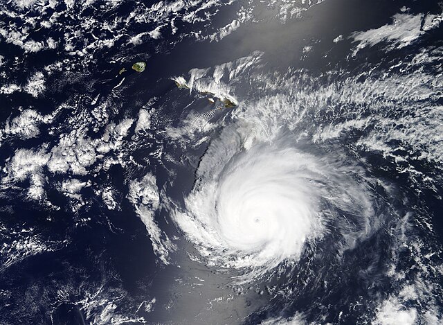
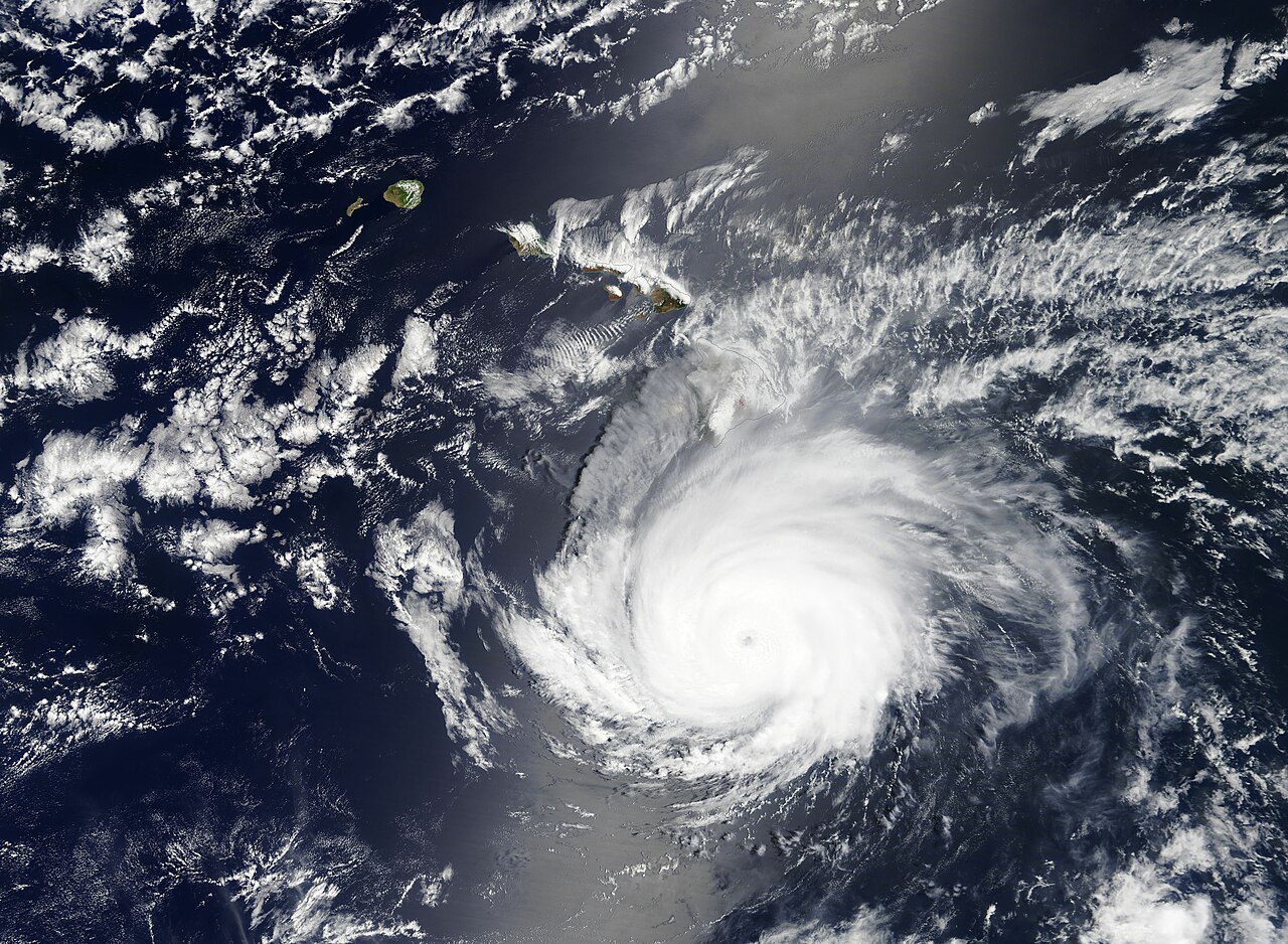
English: Hurricane Hector was churning the waters of the Pacific Ocean just south of Hawaii as NASA’s Terra satellite passed overhead in early August, 2018. The Moderate Resolution Imaging Spectroradiometer (MODIS) on board that satellite acquired a true-color image of the storm on August 8.
According to the Central Pacific Hurricane Center (CPHC), at 15:00 UTC (11:00 a.m. EDT) August 8 the center of Hurricane Hector was located near latitude 16.4 north longitude 153.9 west, roughly within 200 miles of the Big Island of Hawaii. At that time it was carrying maximum sustained winds near 125 mph (205 km/h), making it a Category 3 storm on the Saffir-Simpson hurricane wind scale. Hector developed from Tropical Depression 10-E which was first spotted on July 31 over the Pacific Ocean south-southeast of Acapulco, Mexico. The storm strengthened enough to earn the title of Tropical Storm Hector on August 1. It continued to gain strength as it travelled across the Pacific Ocean towards the Hawaiian Islands. Hurricane Hector reached peak strength as a Category 4 storm on August 6 with maximum sustained winds of 155 mph (250 km/h). At 21:00 UTC (5:00 p.m. EDT) on August 11 the CPHC issued advisory number 46 on Hurricane Hector. At that time, the storm was located near latitude 20.1 north longitude 170.9 west, still south of the Hawaiian Islands. Hector’s maximum sustained winds were estimated at about 109 mph (175 km/h), or a strong Category 2 storm. Hector is forecast to weaken quickly over the next 24 hours then more slowly until it dissipates in open ocean around 120 hours. Hector is expected to closely approach the Northwestern Hawaiian Islands on August 12 – 13 and a Tropical Storm Watch remains posted for the area from Lisianski Island to Pearl and Hermes Atoll. The CPHC advises interests on Midway and Kure Atolls to continue to monitor the progress of Hurricane Hector. |
||
| Date | Taken on 8 August 2018 | ||
| Source |
Hector near Hawaii (direct link)
|
||
| Author | MODIS Land Rapid Response Team, NASA GSFC |
| This media is a product of the Terra mission Credit and attribution belongs to the mission team, if not already specified in the "author" row |
Licensing[edit]
.jpg&action=edit§ion=2)
| This file is in the public domain in the United States because it was solely created by NASA. NASA copyright policy states that "NASA material is not protected by copyright unless noted". (See Template:PD-USGov, NASA copyright policy page or JPL Image Use Policy.) | ||
 |
Warnings:
|
File history
Click on a date/time to view the file as it appeared at that time.
| Date/Time | Thumbnail | Dimensions | User | Comment | |
|---|---|---|---|---|---|
| current | 01:35, 17 February 2024 | | 7,280 × 5,333 (4.95 MB) | OptimusPrimeBot (talk | contribs) | #Spacemedia - Upload of http://modis.gsfc.nasa.gov/gallery/images/image08122018_250m.jpg via Commons:Spacemedia |
You cannot overwrite this file.
File usage on Commons
There are no pages that use this file.
.jpg&oldid=852749630)