File:Helmholt - Western Europe early 18th century.jpg
Jump to navigation
Jump to search
Size of this preview: 724 × 599 pixels. Other resolutions: 290 × 240 pixels | 580 × 480 pixels | 928 × 768 pixels | 1,237 × 1,024 pixels | 2,474 × 2,048 pixels | 2,998 × 2,482 pixels.
Original file (2,998 × 2,482 pixels, file size: 2.69 MB, MIME type: image/jpeg)
Captions
Captions
Add a one-line explanation of what this file represents

|
This old map image could be re-created using vector graphics as an SVG file. This has several advantages; see Commons:Media for cleanup for more information. If an SVG form of this image is available, please upload it and afterwards replace this template with
{{vector version available|new image name}}.
It is recommended to name the SVG file “Helmholt - Western Europe early 18th century.svg”—then the template Vector version available (or Vva) does not need the new image name parameter. |


Summary[edit]
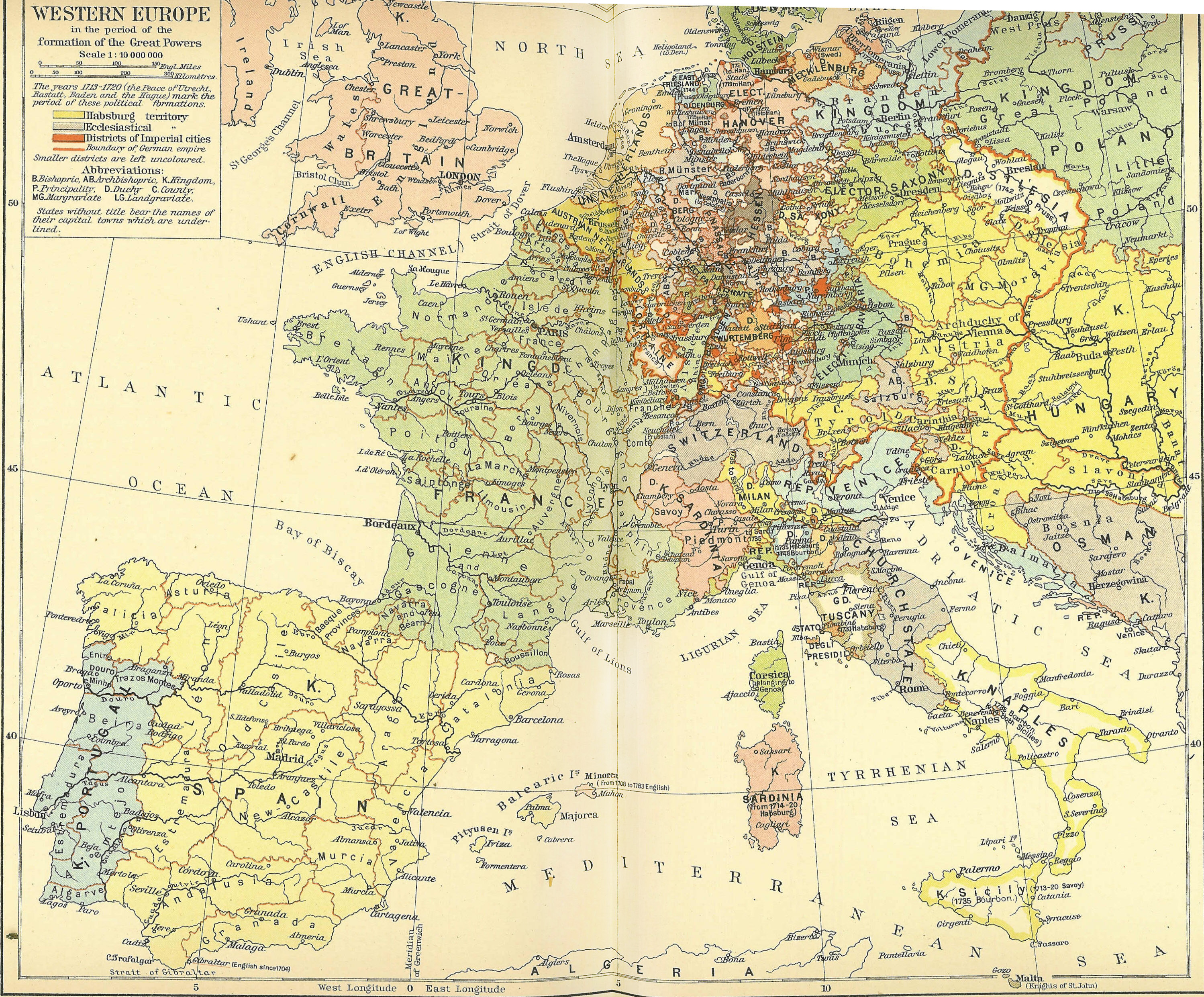
| Description | Map: "Western Europe in the period of the Formation of the Great Powers" (1713-1720 CE) |
| Date | |
| Source | H.F. Helmolt, History of the World, Volume VII, Dodd Mead 1902. Plate between pages 512 and 513. |
| Author | Credited as drawn by London: Wm Heinemann, printed by the Bibliographisches Institut, Leipzig. |
| Permission (Reusing this file) |
Public Domain |
Licensing[edit]
This media file is in the public domain in the United States. This applies to U.S. works where the copyright has expired, often because its first publication occurred prior to January 1, 1929, and if not then due to lack of notice or renewal. See this page for further explanation.
|
 | |
 |
This image might not be in the public domain outside of the United States; this especially applies in the countries and areas that do not apply the rule of the shorter term for US works, such as Canada, Mainland China (not Hong Kong or Macao), Germany, Mexico, and Switzerland. The creator and year of publication are essential information and must be provided. See Wikipedia:Public domain and Wikipedia:Copyrights for more details.
|
File history
Click on a date/time to view the file as it appeared at that time.
| Date/Time | Thumbnail | Dimensions | User | Comment | |
|---|---|---|---|---|---|
| current | 13:04, 24 September 2012 | | 2,998 × 2,482 (2.69 MB) | Marekich (talk | contribs) | Middle part lightened. |
| 04:45, 16 October 2007 |  | 2,998 × 2,482 (2.27 MB) | Jmabel (talk | contribs) | ==Summary== {{Information |Description=Map: "Western Europe in the period of the Formation of the Great Powers" (no explicit date, but looks circa AD 1715) |Source=H.F. Helmolt, ''History of the World'', Volume VII, Dodd Mead 1902. Plate between pages 512 |
You cannot overwrite this file.
File usage on Commons
The following page uses this file: