File:Hertfordshire UK locator map 2010.svg
Siirry navigaatioon
Siirry hakuun

Tämän PNG-esikatselun koko koskien SVG-tiedostoa: 494 × 600 kuvapistettä. Muut resoluutiot: 198 × 240 kuvapistettä | 395 × 480 kuvapistettä | 633 × 768 kuvapistettä | 843 × 1 024 kuvapistettä | 1 687 × 2 048 kuvapistettä | 1 108 × 1 345 kuvapistettä.
Alkuperäinen tiedosto (SVG-tiedosto; oletustarkkuus 1 108 × 1 345 kuvapistettä; tiedostokoko 302 KiB)
Kuvatekstit
Kuvatekstit
Lisää yhden rivin pituinen kuvaus tästä tiedostosta
Yhteenveto
[muokkaa]
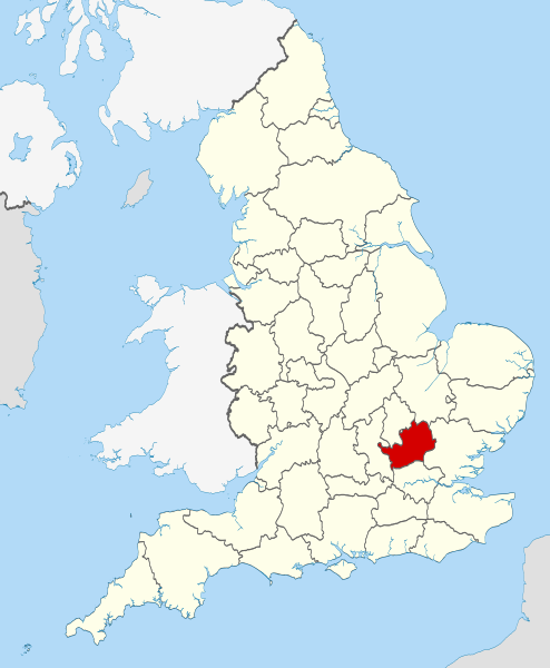
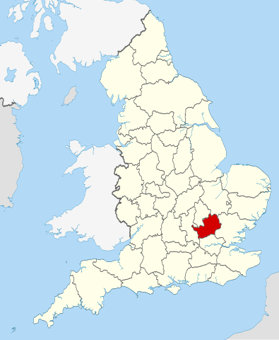
| Kuvaus | Location of the ceremonial county of Hertfordshire within England. |
| Päiväys | |
| Lähde |
National Geospatial-Intelligence Agency
|
| Tekijä | Nilfanion |
Lisenssi
[muokkaa]
Minä, tämän teoksen tekijänoikeuksien haltija, julkaisen täten tämän teoksen seuraavilla lisensseillä:
Tämä tiedosto on lisensoitu Creative Commons Nimeä-JaaSamoin 3.0 Ei sovitettu -lisenssillä.
- Voit:
- jakaa – kopioida, levittää ja esittää teosta
- remiksata – valmistaa muutettuja teoksia
- Seuraavilla ehdoilla:
- nimeäminen – Sinun on mainittava lähde asianmukaisesti, tarjottava linkki lisenssiin sekä merkittävä, mikäli olet tehnyt muutoksia. Voit tehdä yllä olevan millä tahansa kohtuullisella tavalla, mutta et siten, että annat ymmärtää lisenssinantajan suosittelevan sinua tai teoksen käyttöäsi.
- jaa samoin – Jos muutat tai perustat tähän työhön, voit jakaa tuloksena syntyvää työtä vain tällä tai tämän kaltaisella lisenssillä.

|
Voit kopioida, levittää ja/tai muuttaa tätä asiakirjaa GNU Free Documentation License -lisenssin version 1.2 tai minkä tahansa Free Software Foundationin julkaiseman myöhemmän version ehtojen alaisena; ei koske muuttumattomia kohtia, etukannen tekstejä eikä takakannen tekstejä. Kopio tästä lisenssistä on saatavilla osiossa GNU Free Documentation License. |
Voit valita haluamasi lisenssin.

|
This is one of the images forming part of the Valued image set: Locator maps of the Ceremonial counties of England on Wikimedia Commons. The image set has been assessed under the valued image set criteria and is considered the most valued set on Commons within the scope:
Locator maps of the Ceremonial counties of England
You can see its nomination at Commons:Valued image candidates/Locator maps of English ceremonial counties. |
Tiedoston historia
Päiväystä napsauttamalla näet, millainen tiedosto oli kyseisellä hetkellä.
| Päiväys | Pienoiskuva | Koko | Käyttäjä | Kommentti | |
|---|---|---|---|---|---|
| nykyinen | 23. marraskuuta 2010 kello 22.38 | | 1 108 × 1 345 (302 KiB) | Nilfanion (keskustelu | muokkaukset) | == Summary == {{Information |Description=Location of the ceremonial county of Hertfordshire within England. |Source=Ordnance Survey [https://www.ordnancesurvey.co.uk/opendatadownload/products.html OpenData]: *Coun |
Et voi tallentaa uutta tiedostoa tämän tilalle.
Tiedoston käyttö
Seuraavat 35 sivua käyttävät tätä tiedostoa:
- Valued image set: Locator maps of the Ceremonial counties of England
- Commons:Valued image candidates/Locator maps of English ceremonial counties
- Category:Almshouses in Hertfordshire
- Category:Alumni by school in Hertfordshire
- Category:Births in Hertfordshire
- Category:Bridges in Hertfordshire
- Category:Burials in Hertfordshire
- Category:Canals in Hertfordshire
- Category:Castles in Hertfordshire
- Category:Cemeteries in Hertfordshire
- Category:Deaths in Hertfordshire
- Category:Hertfordshire
- Category:Hertfordshire in the 1970s
- Category:Hertfordshire in the 1980s
- Category:Hertfordshire in the 1990s
- Category:Hertfordshire in the 19th century
- Category:Hertfordshire in the 2010s
- Category:Hertfordshire in the 20th century
- Category:Hertfordshire in the 21st century
- Category:Hospitals in Hertfordshire
- Category:Maps of Hertfordshire
- Category:Meadows in Hertfordshire
- Category:People of Hertfordshire
- Category:Populated places in Hertfordshire
- Category:Rail transport in Hertfordshire
- Category:Rivers of Hertfordshire
- Category:Roads in Hertfordshire
- Category:Rose gardens in Hertfordshire
- Category:Sports in Hertfordshire
- Category:Towns in Hertfordshire
- Category:Transport infrastructure in Hertfordshire
- Category:Tunnels in Hertfordshire
- Category:Views of Hertfordshire
- Category:Visitor attractions in Hertfordshire
- Category:Windmills in Hertfordshire
Tiedoston järjestelmänlaajuinen käyttö
Seuraavat muut wikit käyttävät tätä tiedostoa:
- Käyttö kohteessa af.wikipedia.org
- Käyttö kohteessa an.wikipedia.org
- Käyttö kohteessa ar.wikipedia.org
- Käyttö kohteessa ast.wikipedia.org
- Käyttö kohteessa az.wikipedia.org
- Käyttö kohteessa be-tarask.wikipedia.org
- Käyttö kohteessa be.wikipedia.org
- Käyttö kohteessa bg.wikipedia.org
- Käyttö kohteessa bn.wikipedia.org
- Käyttö kohteessa ca.wikipedia.org
- Käyttö kohteessa ceb.wikipedia.org
- Käyttö kohteessa cs.wikipedia.org
- Käyttö kohteessa dag.wikipedia.org
- Käyttö kohteessa en.wikipedia.org
- Hertfordshire
- Preston, Hertfordshire
- Ickleford
- River Rib
- Garston, Hertfordshire
- Colney Heath
- Weston, Hertfordshire
- Nasty, Hertfordshire
- Newmarket Ridge
- Bearton
- Pirton, Hertfordshire
- Gosmore
- Holwell, Hertfordshire
- Whitwell, Hertfordshire
- St Paul's Walden
- Lilley, Hertfordshire
- Graveley, Hertfordshire
- Hitchin Oughton
- Bendish
- Puckeridge
- Ayot Green
- Therfield Heath
- Datchworth
- Harpenden Rural
- Template:Hertfordshire-geo-stub
- Albury, Hertfordshire
- Charlton, Hertfordshire
- Anstey, Hertfordshire
- River Stort
- Aspenden
- Ayot St Peter
- Barkway
- Bengeo Rural
- Buckland, Hertfordshire
- Ridge, Hertfordshire
- Leverstock Green
Näytä lisää tämän tiedoston järjestelmänlaajuista käyttöä.