File:Hertfordshire UK locator map 2010.svg
Pereiti į navigaciją
Jump to search

Rinkmenos SVG peržiūros PNG dydisː 494 × 600 taškų. Kitos 6 rezoliucijos: 198 × 240 taškų | 395 × 480 taškų | 633 × 768 taškų | 843 × 1 024 taškų | 1 687 × 2 048 taškų | 1 108 × 1 345 taškų.
Pradinė rinkmena (SVG rinkmena, formaliai 1 108 × 1 345 taškų, rinkmenos dydis: 302 KiB)
Captions
Captions
Add a one-line explanation of what this file represents
Aprašymas[keisti]
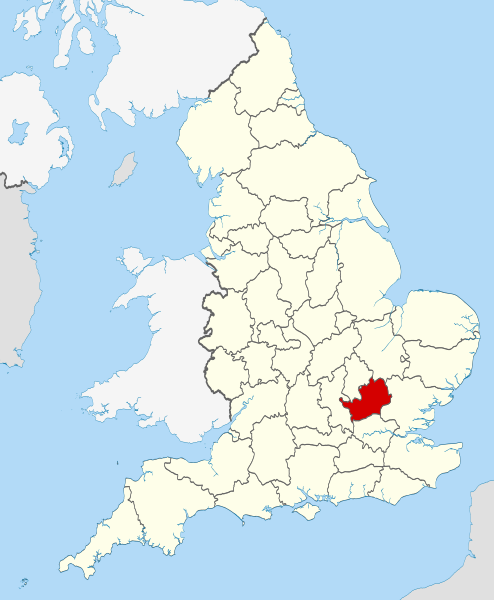
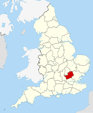
| Aprašymas | Location of the ceremonial county of Hertfordshire within England. |
| Data | |
| Šaltinis |
National Geospatial-Intelligence Agency
|
| Autorius | Nilfanion |
Licencija[keisti]
Aš, šio darbo autoriaus teisių savininkas, publikuoju jį su šiomis licencijomis:
Šiam failui taikoma Creative Commons Attribution-Share Alike 3.0 Unported licencija.
- Jūs galite:
- dalintis – kopijuoti, platinti bei persiųsti šį darbą
- pri(si)taikyti – adaptuoti darbą
- Su šiomis sąlygomis:
- autoriaus nurodymas – Turite pateikti atitinkamą kreditą, pateikti nuorodą į licenciją ir nurodyti, ar buvo atlikti pakeitimai. Tai galite padaryti bet kokiu būdu, bet ne taip, kad licencijos išdavėjas patvirtintų jus ar jūsų naudojimą.
- dalinkis panašiai – Jei perdirbsite, redaguosite ar atkursite šį darbą, jį galėsite platinti tik su tokia pačia ar panašia į šią licencija.

|
Suteikiamas leidimas kopijuoti, platinti ir/ar redaguoti šį dokumentą pagal GNU Free Documentation licencijos versijos 1.2 ar bet kurios vėlesnės versijos sąlygas, publikuotas Free Software Foundation; be nekintamų dalių, be priekinių ir galinių tekstinių žymų viršeliuose. Šios licencijos kopija įtraukta dalyje, pavadintoje GNU Free Documentation License. |
Galite pasirinkti, kurią licenciją norite naudoti.

|
This is one of the images forming part of the Valued image set: Locator maps of the Ceremonial counties of England on Wikimedia Commons. The image set has been assessed under the valued image set criteria and is considered the most valued set on Commons within the scope:
Locator maps of the Ceremonial counties of England
You can see its nomination at Commons:Valued image candidates/Locator maps of English ceremonial counties. |
Rinkmenos istorija
Paspauskite ant datos/laiko, kad pamatytumėte rinkmeną tokią, kokia ji buvo tuo metu.
| Data/Laikas | Miniatiūra | Matmenys | Naudotojas | Paaiškinimas | |
|---|---|---|---|---|---|
| dabartinis | 22:38, 23 lapkričio 2010 | | 1 108 × 1 345 (302 KiB) | Nilfanion (aptarimas | indėlis) | == Summary == {{Information |Description=Location of the ceremonial county of Hertfordshire within England. |Source=Ordnance Survey [https://www.ordnancesurvey.co.uk/opendatadownload/products.html OpenData]: *Coun |
Jūs negalite perrašyti šios rinkmenos.
Rinkmenos naudojimas
Šie puslapiai naudoja šią rinkmeną:
- Valued image set: Locator maps of the Ceremonial counties of England
- Commons:Valued image candidates/Locator maps of English ceremonial counties
- Category:Almshouses in Hertfordshire
- Category:Alumni by school in Hertfordshire
- Category:Births in Hertfordshire
- Category:Bridges in Hertfordshire
- Category:Burials in Hertfordshire
- Category:Canals in Hertfordshire
- Category:Castles in Hertfordshire
- Category:Cemeteries in Hertfordshire
- Category:Deaths in Hertfordshire
- Category:Hertfordshire
- Category:Hertfordshire in the 1970s
- Category:Hertfordshire in the 1980s
- Category:Hertfordshire in the 1990s
- Category:Hertfordshire in the 19th century
- Category:Hertfordshire in the 2010s
- Category:Hertfordshire in the 20th century
- Category:Hertfordshire in the 21st century
- Category:Hospitals in Hertfordshire
- Category:Maps of Hertfordshire
- Category:Meadows in Hertfordshire
- Category:People of Hertfordshire
- Category:Populated places in Hertfordshire
- Category:Rail transport in Hertfordshire
- Category:Rivers of Hertfordshire
- Category:Roads in Hertfordshire
- Category:Rose gardens in Hertfordshire
- Category:Sports in Hertfordshire
- Category:Towns in Hertfordshire
- Category:Transport infrastructure in Hertfordshire
- Category:Tunnels in Hertfordshire
- Category:Views of Hertfordshire
- Category:Visitor attractions in Hertfordshire
- Category:Windmills in Hertfordshire
Visuotinis rinkmenos naudojimas
Ši rinkmena naudojama šiose viki svetainėse:
- Naudojama af.wikipedia.org
- Naudojama an.wikipedia.org
- Naudojama ar.wikipedia.org
- Naudojama ast.wikipedia.org
- Naudojama az.wikipedia.org
- Naudojama be-tarask.wikipedia.org
- Naudojama be.wikipedia.org
- Naudojama bg.wikipedia.org
- Naudojama bn.wikipedia.org
- Naudojama ca.wikipedia.org
- Naudojama ceb.wikipedia.org
- Naudojama cs.wikipedia.org
- Naudojama dag.wikipedia.org
- Naudojama en.wikipedia.org
- Hertfordshire
- Preston, Hertfordshire
- Ickleford
- River Rib
- Garston, Hertfordshire
- Colney Heath
- Weston, Hertfordshire
- Nasty, Hertfordshire
- Newmarket Ridge
- Bearton
- Pirton, Hertfordshire
- Gosmore
- Holwell, Hertfordshire
- Whitwell, Hertfordshire
- St Paul's Walden
- Lilley, Hertfordshire
- Graveley, Hertfordshire
- Hitchin Oughton
- Bendish
- Puckeridge
- Ayot Green
- Therfield Heath
- Datchworth
- Harpenden Rural
- Template:Hertfordshire-geo-stub
- Albury, Hertfordshire
- Charlton, Hertfordshire
- Anstey, Hertfordshire
- River Stort
- Aspenden
- Ayot St Peter
- Barkway
- Bengeo Rural
- Buckland, Hertfordshire
- Ridge, Hertfordshire
- Leverstock Green
Žiūrėti visuotinį šios rinkmenos naudojimą.