File:Hessen-Homburg.png
跳转到导航
跳转到搜索
本预览的尺寸:800 × 480像素。 其他分辨率:320 × 192像素 | 1,024 × 614像素 | 1,280 × 768像素 | 2,362 × 1,417像素。
原始文件 (2,362 × 1,417像素,文件大小:582 KB,MIME类型:image/png)
说明
说明
添加一行文字以描述该文件所表现的内容
摘要
[编辑]
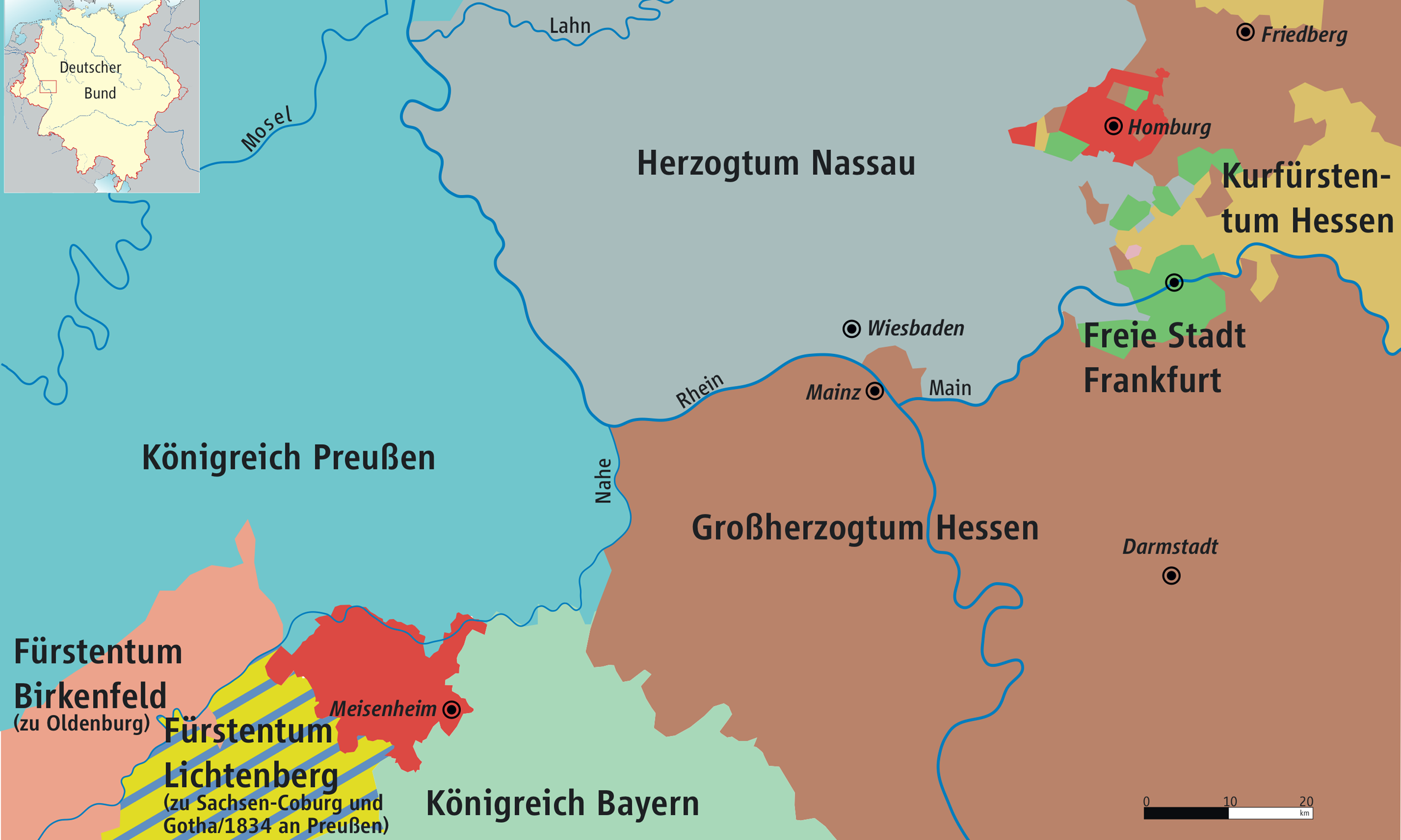
| 描述 | Karte von Hessen-Homburg und Mittelrheingebiet 1816–1866 / Map of Hesse-Homburg and Middle Rhine 1816–1866 |
| 日期 | |
| 来源 | own drawing/Source of Information: Putzger – Historischer Weltatlas, 89. Auflage, 1965 & de: Jean Joseph Tranchot / de: Karl von Müffling |
| 作者 | Ziegelbrenner |
| 授权 (二次使用本文件) |
GNU FDL |

|
|
许可协议
[编辑]
我,本作品著作权人,特此采用以下许可协议发表本作品:

|
已授权您依据自由软件基金会发行的无固定段落及封面封底文字(Invariant Sections, Front-Cover Texts, and Back-Cover Texts)的GNU自由文件许可协议1.2版或任意后续版本的条款,复制、传播和/或修改本文件。该协议的副本请见“GNU Free Documentation License”。 |
| 本文件采用知识共享署名-相同方式共享 3.0 未本地化版本许可协议授权。 | ||
| ||
| 本许可协议标签作为GFDL许可协议更新的组成部分被添加至本文件。 |
您可以选择您需要的许可协议。

|
File:Hessen-Homburg.svg是此文件的矢量版本。 应当将此点阵图片替换为该文件。
File:Hessen-Homburg.png → File:Hessen-Homburg.svg
更多信息请参阅Help:SVG/zh。 |
 |
文件历史
点击某个日期/时间查看对应时刻的文件。
| 日期/时间 | 缩略图 | 大小 | 用户 | 备注 | |
|---|---|---|---|---|---|
| 当前 | 2010年6月9日 (三) 13:56 | | 2,362 × 1,417(582 KB) | Ziegelbrenner(留言 | 贡献) | 2010-06-09 |
| 2008年9月26日 (五) 14:30 |  | 2,362 × 1,408(584 KB) | Ziegelbrenner(留言 | 贡献) | {{Information |Description= |Source= |Date= |Author= |Permission= |other_versions= }} | |
| 2007年10月8日 (一) 12:30 |  | 2,840 × 1,691(245 KB) | Ziegelbrenner(留言 | 贡献) | ||
| 2007年1月4日 (四) 12:41 |  | 2,837 × 1,687(933 KB) | Ziegelbrenner(留言 | 贡献) | ||
| 2006年12月22日 (五) 14:54 |  | 2,837 × 1,694(863 KB) | Ziegelbrenner(留言 | 贡献) | ||
| 2006年8月1日 (二) 10:36 |  | 652 × 390(89 KB) | Ziegelbrenner(留言 | 贡献) | == Summary == * Description: Karte von Hessen-Homburg und Mittelrheingebiet 1816–1866 / Map of Hesse-Homburg and Middle Rhein 1816–1866 * Source of Information: Jean Joseph Tranchot und Karl von Müffling * Author: kgberger | |
| 2006年7月18日 (二) 10:52 |  | 835 × 416(55 KB) | Ziegelbrenner(留言 | 贡献) | == Summary == Deutscher_Bund.png * Description: Karte von Hessen-Homburg und Mittelrheingebiet 1816-1866 / Map of Hesse-Homburg and Middle Rhein * Source: Tranchot und von Müffling * Author: [[:de:Benutzer |
您不可以覆盖此文件。
文件用途
没有页面使用本文件。
全域文件用途
以下其他wiki使用此文件:
- bg.wikipedia.org上的用途
- eo.wikipedia.org上的用途
- et.wikipedia.org上的用途
- gd.wikipedia.org上的用途
- it.wikipedia.org上的用途
- no.wikipedia.org上的用途
- pl.wikipedia.org上的用途
- ru.wikipedia.org上的用途
- sv.wikipedia.org上的用途
- zh.wikipedia.org上的用途