File:Hillenraad-plattegrond.svg
Jump to navigation
Jump to search

Size of this PNG preview of this SVG file: 400 × 234 pixels. Other resolutions: 320 × 187 pixels | 640 × 374 pixels | 1,024 × 599 pixels | 1,280 × 749 pixels | 2,560 × 1,498 pixels.
Original file (SVG file, nominally 400 × 234 pixels, file size: 40 KB)
Captions
Captions
Add a one-line explanation of what this file represents
Summary
[edit]
| Description |
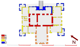
English: map of Castle Hillenraad - (A) late 14th century (B), second half 17th century (C), second quarter 18th century (D) 3rd quarter 18th century. Scale 10 meters per unit. North is left.
Nederlands: Plattegrond van kasteel Hillenraad - (A) eind 14e eeuw (B) 2e helft 17e eeuw (C) 2e kwart 18e eeuw (D) 3e kwart 18e eeuw. Schaal 10 meter per eenheid. Noorden is linksboven.
Deutsch: Karte von Schloss Hillenraad - (A), Ende des 14. Jahrhunderts (B), zweite Hälfte 17. Jahrhundert (C), im zweiten Quartal des 18. Jahrhunderts (D) 3. Quartal des 18. Jahrhunderts. Scale 10 Meter pro Einheit. Norden ist links. |
| Date | |
| Source | Own work |
| Author | Arch |
| Object location | | View this and other nearby images on: OpenStreetMap |
|---|
|
This is an image of rijksmonument number 339679 Information from structured data: |
Licensing
[edit]
I, the copyright holder of this work, hereby publish it under the following license:
| This file is made available under the Creative Commons CC0 1.0 Universal Public Domain Dedication. | |
| The person who associated a work with this deed has dedicated the work to the public domain by waiving all of their rights to the work worldwide under copyright law, including all related and neighboring rights, to the extent allowed by law. You can copy, modify, distribute and perform the work, even for commercial purposes, all without asking permission.
|
File history
Click on a date/time to view the file as it appeared at that time.
| Date/Time | Thumbnail | Dimensions | User | Comment | |
|---|---|---|---|---|---|
| current | 04:21, 20 August 2011 | | 400 × 234 (40 KB) | Arch (talk | contribs) | == Summary == {{Information |Description ={{en|1=Hillenraad-plattegrond}} {{nl|1=Hillenraad-plattegrond}} |Source ={{own}} |Author =Arch |Date =2011 |Permission =see below |other_versions = }} [[Category:Ri |
You cannot overwrite this file.
File usage on Commons
There are no pages that use this file.
File usage on other wikis
The following other wikis use this file:
- Usage on nl.wikipedia.org