File:Himalaya annotated.jpg
跳转到导航
跳转到搜索

本预览的尺寸:800 × 530像素。 其他分辨率:320 × 212像素 | 640 × 424像素 | 1,000 × 662像素。
原始文件 (1,000 × 662像素,文件大小:413 KB,MIME类型:image/jpeg)
说明
说明
添加一行文字以描述该文件所表现的内容
| 描述 |
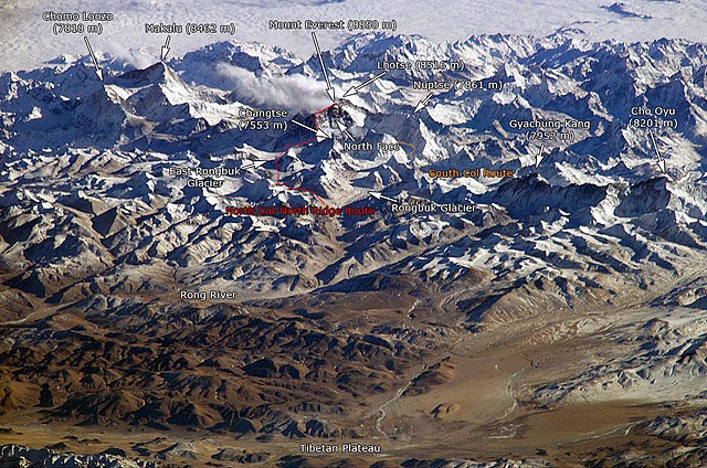
English: The Himalayan mountain range with Mount Everest as seen from the International Space Station looking south-south-east over the Tibetan Plateau. Four of the world's fourteen eight-thousanders, mountains higher than 8000 metres, can be seen, Makalu (8462 m), Everest (8850 m), Lhotse (8516 m) and Cho Oyu (8201 m). The South Col Route is Mount Everest's most often used climbing route. |
|||||
| 来源 |
This image is a modified version of this NASA Image. Annotations have been added by Janderk Jan Derk. If anyone finds errors please leave a note in the discussions area of this page. Original image: NASA |
|||||
| 作者 | NASA, Janderk Jan Derk | |||||
| 授权 (二次使用本文件) |
|
|||||
| 其他版本 |
本文件衍生自: Himalayas.jpg |

文件历史
点击某个日期/时间查看对应时刻的文件。
| 日期/时间 | 缩略图 | 大小 | 用户 | 备注 | |
|---|---|---|---|---|---|
| 当前 | 2006年12月6日 (三) 22:39 | | 1,000 × 662(413 KB) | Janderk~commonswiki(留言 | 贡献) | Slight change in Nuptse location to try to make it point more to Nuptse I. |
| 2006年12月5日 (二) 12:08 |  | 1,000 × 662(414 KB) | Janderk~commonswiki(留言 | 贡献) | Fixed errors. See talk page. | |
| 2005年2月19日 (六) 18:23 |  | 1,000 × 662(416 KB) | RedWolf(留言 | 贡献) | Himalaya - annotated |
您不可以覆盖此文件。
文件用途
以下4个页面使用本文件:
全域文件用途
以下其他wiki使用此文件:
- af.wikipedia.org上的用途
- anp.wikipedia.org上的用途
- ast.wikipedia.org上的用途
- awa.wikipedia.org上的用途
- azb.wikipedia.org上的用途
- az.wikipedia.org上的用途
- ba.wikipedia.org上的用途
- bcl.wikipedia.org上的用途
- beta.wikiversity.org上的用途
- be.wikipedia.org上的用途
- bg.wikipedia.org上的用途
- blk.wikipedia.org上的用途
- bn.wikipedia.org上的用途
- bs.wikipedia.org上的用途
- ca.wikipedia.org上的用途
- ckb.wikipedia.org上的用途
- csb.wikipedia.org上的用途
- cs.wikipedia.org上的用途
- da.wikipedia.org上的用途
- de.wikipedia.org上的用途
- el.wikipedia.org上的用途
- en.wikipedia.org上的用途
- eo.wikipedia.org上的用途
查看此文件的更多全域用途。