File:Historical map of Paris Metro - 1899-2012.ogv
Original file (Ogg Theora video file, length 3 min 48 s, 1,920 × 1,080 pixels, 2.37 Mbps, file size: 64.31 MB)
Captions
Captions
Summary
[edit]| Description |
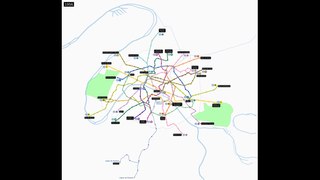
Français : Carte animée représentant l'état des réseaux de métro et RER parisiens au 31 décembre de chaque année. Carte géographiquement exacte. English: Animated map showing the state of Paris Metro and RER networks, as of December 31 of each year. Geographically accurate map. |
| Date | |
| Source | Own work |
| Author | Benjamin Smith |
| Other versions |
Derived (for rivers) from File:Paris and inner ring.svg by Metropolitan (public domain). GIF version at File:Historical map of Paris Metro - 1899-2012.gif |
Licensing
[edit]- You are free:
- to share – to copy, distribute and transmit the work
- to remix – to adapt the work
- Under the following conditions:
- attribution – You must give appropriate credit, provide a link to the license, and indicate if changes were made. You may do so in any reasonable manner, but not in any way that suggests the licensor endorses you or your use.
- share alike – If you remix, transform, or build upon the material, you must distribute your contributions under the same or compatible license as the original.
Although this is not compulsory, I'm always glad to read that my work is useful to others. If you could send me an e-mail at benji dot wiki at gmail dot com to inform me that you are using my work, I'd be delighted. Thanks a lot!
Envie d'utiliser cette image en dehors des projets Wikimedia ? N'hésitez pas ! Cette image est placée sous licence libre de façon à ce que vous puissiez l'utiliser librement, sans avoir besoin d'une autorisation de ma part. Tout ce que vous devez faire, c'est respecter les termes de la licence et me créditer ainsi :
Bien que ce ne soit pas obligatoire, je suis toujours ravi d'apprendre que mon travail a été utile à d'autres. Si vous pouviez m'envoyer un courriel à benji point wiki arobase gmail point com pour m'informer du fait que vous utilisez mon travail, ce serait top. Merci d'avance !
File history
Click on a date/time to view the file as it appeared at that time.
| Date/Time | Thumbnail | Dimensions | User | Comment | |
|---|---|---|---|---|---|
| current | 20:27, 10 February 2013 | 3 min 48 s, 1,920 × 1,080 (64.31 MB) | Benjism89 (talk | contribs) | {{Information |Description ={{fr|1=Carte animée représentant l'état des réseaux de métro et RER parisiens au 31 décembre de chaque année. Carte géographiquement exacte.}} |Source ={{own}} |Author =Benjism89... |
You cannot overwrite this file.
File usage on Commons
There are no pages that use this file.
Transcode status
Update transcode statusFile usage on other wikis
The following other wikis use this file:
- Usage on de.wikipedia.org