File:Hitler-Headquarters-Europe.png

原始文件 (1,120 × 790像素,文件大小:473 KB,MIME类型:image/png)
说明
说明
摘要
[编辑]| 描述 |
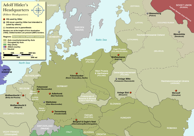
Map of Adolf Hitler's Headquarters (Führer Headquarters) in Europe 1933-1945. Countries that were part of the Axis/annexed by Axis are colored dark green (Germany, Austria, Hungary, Romania & Italy etc). |
| 日期 | |
| 来源 | Self-made, based on information from references below |
| 作者 | User:Dna-Dennis |
| 授权 (二次使用本文件) |
CC, see below. The map is completely unrestricted for any Wikipedia/Wikimedia project. If you have any opinions/suggestions, please contact me here on my talk page. |
| 其他版本 |
|


.png)

|
此historical map图片可使用矢量图形重新创建为SVG文件。这具有很多好处;更多信息请参见共享资源:待清理媒体。如果存在此图片的SVG格式,请将其上传,然后将此模板替换为
{{vector version available|新图片名称}}。
建议您将SVG命名为“Hitler-Headquarters-Europe.svg”,这样在使用Vector version available(或Vva)模板时就不需要填写新图片名称参数。 |
许可协议
[编辑]
- 您可以自由地:
- 共享 – 复制、发行并传播本作品
- 修改 – 改编作品
- 惟须遵守下列条件:
- 署名 – 您必须对作品进行署名,提供授权条款的链接,并说明是否对原始内容进行了更改。您可以用任何合理的方式来署名,但不得以任何方式表明许可人认可您或您的使用。
References
[编辑]
- Beevor, Antony, Berlin - The Downfall 1945
- Eberle, Henrik and Uhl, Matthias, The Unknown Hitler
- Hansen, Hans-Josef: Felsennest - Das vergessene Führerhauptquartier in der Eifel. Bau, Nutzung, Zerstörung. Aachen 2006, Helios-Verlag, ISBN 3-938208-21-X.
- Kuffner, Alexander: Zeitreiseführer Eifel 1933-45. Helios, Aachen 2007, ISBN 978-3-938208-42-7.
- Raiber, Richard, Guide to Hitler's Headquarters, After the Battle archive copy at the Wayback Machine, No.19, Special Edition, Battle of Britain International Ltd, 1977, London
- Ramsey, Winston G. (editor) & Posch, Tom (researcher), The Berlin Führerbunker: The Thirteenth Hole, After the Battle archive copy at the Wayback Machine, No.61, Special Edition, Battle of Britain International Ltd, 1988, London
- von Loringhoven, Bernd Freytag/d’Alançon, François: Mit Hitler im Bunker. Aufzeichnungen aus dem Führerhauptquartier Juli 1944 – April 1945. Berlin 2005, wjs-Verlag, ISBN 3-937989-14-5.
- Schulz, Alfons: Drei Jahre in der Nachrichtenzentrale des Führerhauptquartiers. Christiana-Verlag, Stein am Rhein. 2. Aufl. 1997. ISBN 3-7171-1028-4.
- Seidler, Franz W./Zeigert, Dieter : Die Führerhauptquartiere. Anlagen und Planungen im Zweiten Weltkrieg. München: Herbig 2000. ISBN 3-7766-2154-0.
Notes on the individual headquarters
[编辑]
- Adlerhorst (Guide to Hitler's Headquarters, p.51)
- Anlage Mitte (Guide to Hitler's Headquarters, p.48)
- Anlage Süd (Guide to Hitler's Headquarters, p.48)
- Berghof/Eagle's nest (Guide to Hitler's Headquarters, p.2) - please note that the "Eagle's nest" was rarely used
- Bärenhöhle (www.bundesarchiv.de)
- Felsennest (Guide to Hitler's Headquarters, p.4)
- Führerbunker (After The Battle, No.61 (entire))
- Tannenberg (Guide to Hitler's Headquarters, p.18)
- Waldwiese (www.bundesarchiv.de)
- Wasserburg (www.bundesarchiv.de)
- Werwolf (Guide to Hitler's Headquarters, p.48)
- Wolfsschanze (Guide to Hitler's Headquarters, p.28)
- Wolfsschlucht I (Guide to Hitler's Headquarters, p.10)
- Wolfsschlucht II (Guide to Hitler's Headquarters, p.49)
文件历史
点击某个日期/时间查看对应时刻的文件。
| 日期/时间 | 缩略图 | 大小 | 用户 | 备注 | |
|---|---|---|---|---|---|
| 当前 | 2012年4月3日 (二) 08:19 | | 1,120 × 790(473 KB) | Asav(留言 | 贡献) | Wehrwolf -> Werwolf (Correct name, see "Naming" section on en.wp) |
| 2007年12月20日 (四) 03:54 |  | 1,120 × 790(537 KB) | Dna-webmaster~commonswiki(留言 | 贡献) | completely new version with 1942 borders | |
| 2007年12月16日 (日) 23:32 |  | 1,120 × 790(408 KB) | Dna-webmaster~commonswiki(留言 | 贡献) | updated map - please suggest changes before making any bold moves, please | |
| 2007年12月10日 (一) 17:25 |  | 1,096 × 704(37 KB) | Matthead(留言 | 贡献) | Modified version, file size reduced, country coloring removed (countries as of 2007 were not involved in WW2) | |
| 2007年10月21日 (日) 04:27 |  | 1,120 × 790(407 KB) | Dna-webmaster~commonswiki(留言 | 贡献) | new version with new colors | |
| 2007年10月16日 (二) 14:11 |  | 1,120 × 790(447 KB) | Dna-webmaster~commonswiki(留言 | 贡献) | new version | |
| 2007年10月14日 (日) 20:46 |  | 1,120 × 790(423 KB) | Dna-webmaster~commonswiki(留言 | 贡献) | quick update | |
| 2007年10月14日 (日) 20:38 |  | 1,120 × 790(425 KB) | Dna-webmaster~commonswiki(留言 | 贡献) | {{Information |Description=Map of Adolf Hitler's Headquarters (Führer Headquarters) in Europe 1933-1945.<br><br> For more detailed information, please see below. |Source=Self-made |Date=October 14, 2007 |Author=[http://en.wikipedia.org/wiki/User:Dna-webm |
您不可以覆盖此文件。
文件用途
以下7个页面使用本文件:
全域文件用途
以下其他wiki使用此文件:
- ar.wikipedia.org上的用途
- ast.wikipedia.org上的用途
- ba.wikipedia.org上的用途
- bg.wikipedia.org上的用途
- ca.wikipedia.org上的用途
- cs.wikipedia.org上的用途
- da.wikipedia.org上的用途
- el.wikipedia.org上的用途
- en.wikipedia.org上的用途
- es.wikipedia.org上的用途
- et.wikipedia.org上的用途
- fi.wikipedia.org上的用途
- fr.wikipedia.org上的用途
- he.wikipedia.org上的用途
- id.wikipedia.org上的用途
- it.wikipedia.org上的用途
- ja.wikipedia.org上的用途
- ko.wikipedia.org上的用途
- ms.wikipedia.org上的用途
- nl.wikipedia.org上的用途
- no.wikipedia.org上的用途
- pl.wikipedia.org上的用途
查看此文件的更多全域用途。