File:Holding position sign and marking for instrument landing system (ILS) critical area boundary.png
Jump to navigation
Jump to search

Size of this preview: 523 × 599 pixels. Other resolutions: 210 × 240 pixels | 419 × 480 pixels | 671 × 768 pixels | 894 × 1,024 pixels | 1,322 × 1,514 pixels.
Original file (1,322 × 1,514 pixels, file size: 1.6 MB, MIME type: image/png)
Captions
Captions
Add a one-line explanation of what this file represents
Summary[edit]
_critical_area_boundary.png&action=edit§ion=1)
| Description |
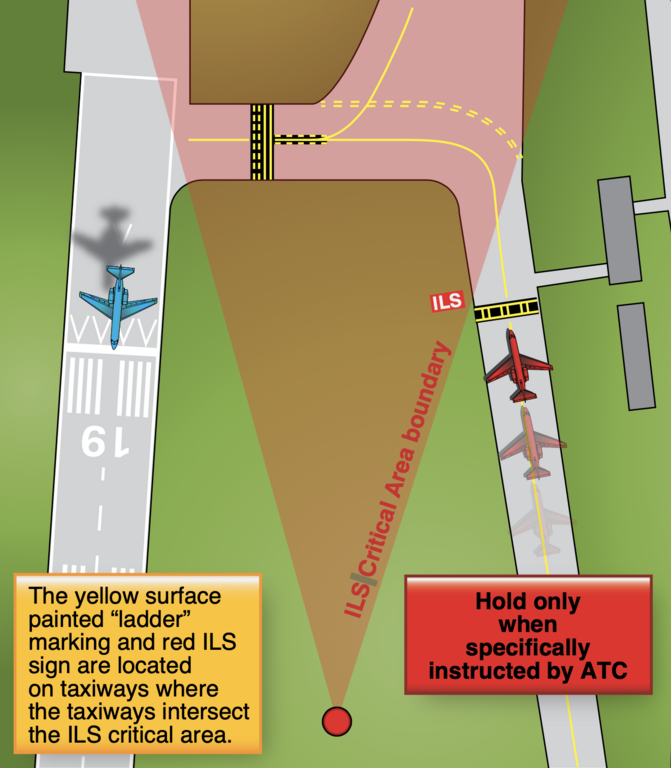
English: The instrument landing system (ILS) broadcasts signals to arriving instrument aircraft to guide them to the runway. Each of these ILSs have critical areas that must be kept clear of all obstacles in order to ensure quality of the broadcast signal.
The ILS critical area hold sign has white characters, outlined in black, on a red background and is installed adjacent to the ILS holding position markings. The holding position markings for the ILS critical area appear on the pavement as a horizontal yellow ladder extending across the width of the taxiway. |
| Date | |
| Source | Pilot's Handbook of Aeronautical Knowledge (FAA-H-8083-25C), chapter 14, page 14 |
| Author | Federal Aviation Administration |
Licensing[edit]
_critical_area_boundary.png&action=edit§ion=2)
This image or file is a work of a Federal Aviation Administration employee, taken or made as part of that person's official duties. As a work of the U.S. federal government, the image is in the public domain in the United States.
|
 |
File history
Click on a date/time to view the file as it appeared at that time.
| Date/Time | Thumbnail | Dimensions | User | Comment | |
|---|---|---|---|---|---|
| current | 23:15, 30 July 2023 | | 1,322 × 1,514 (1.6 MB) | 痛 (talk | contribs) | Uploaded a work by {{label|Q335357}} from Pilot's Handbook of Aeronautical Knowledge (FAA-H-8083-25C), chapter 14, page 14 with UploadWizard |
You cannot overwrite this file.
File usage on Commons
There are no pages that use this file.
File usage on other wikis
The following other wikis use this file:
- Usage on en.wikipedia.org
_critical_area_boundary.png&oldid=788465642)