File:Hudson bay explorer.png
跳至導覽
跳至搜尋
無更高解析度可提供。
Hudson_bay_explorer.png (550 × 442 像素,檔案大小:449 KB,MIME 類型:image/png)
說明
說明
添加單行說明來描述出檔案所代表的內容
| 描述 |
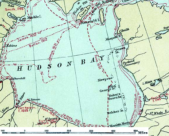
English: Map of the routes of the main European explorers in Hudson Bay, Canada. |
|||||
| 日期 | ||||||
| 來源 | Excerpted from 1st Edition, 1906, Atlas of Canada - Routes of Explorers,1497 to 1905. | |||||
| 作者 | Department of the Interior, Ottawa | |||||
| 授權許可 (重用此檔案) |
Crown copyright expired.
|

原始上傳日誌
[編輯]
The original description page was here. All following user names refer to en.wikipedia.
- 2007-01-26 22:28 CyclePat 550×442×8 (459278 bytes) ==Description== This map shows the routes followed by the principal explorers of what is now Canada, from 1497 up to 1905. The map also shows the location of forts with the date of their establishment. It was created using [[:image:Canada, Routes of Explo
檔案歷史
點選日期/時間以檢視該時間的檔案版本。
| 日期/時間 | 縮圖 | 尺寸 | 使用者 | 備註 | |
|---|---|---|---|---|---|
| 目前 | 2008年7月10日 (四) 11:41 | | 550 × 442(449 KB) | Urdangaray(留言 | 貢獻) | {{Information |Description={{en|thumb|400px|right|Canada, Routes of Explorers,1497 to 1905 This map shows the routes followed by the principal explorers of what is now Canada, from 1497 up to 190 |
無法覆蓋此檔案。
檔案用途
沒有使用此檔案的頁面。
全域檔案使用狀況
以下其他 wiki 使用了這個檔案:
- arz.wikipedia.org 的使用狀況
- ast.wikipedia.org 的使用狀況
- az.wikipedia.org 的使用狀況
- bg.wikipedia.org 的使用狀況
- ca.wikipedia.org 的使用狀況
- cv.wikipedia.org 的使用狀況
- de.wikipedia.org 的使用狀況
- en.wikipedia.org 的使用狀況
- es.wikipedia.org 的使用狀況
- hi.wikipedia.org 的使用狀況
- nn.wikipedia.org 的使用狀況
- ru.wikipedia.org 的使用狀況
- zh.wikipedia.org 的使用狀況