File:Humber Bay Arch Bridge in 2011 -a.jpg
Original file (2,428 × 1,821 pixels, file size: 504 KB, MIME type: image/jpeg)
Captions
Captions
Summary[edit]
| Description |
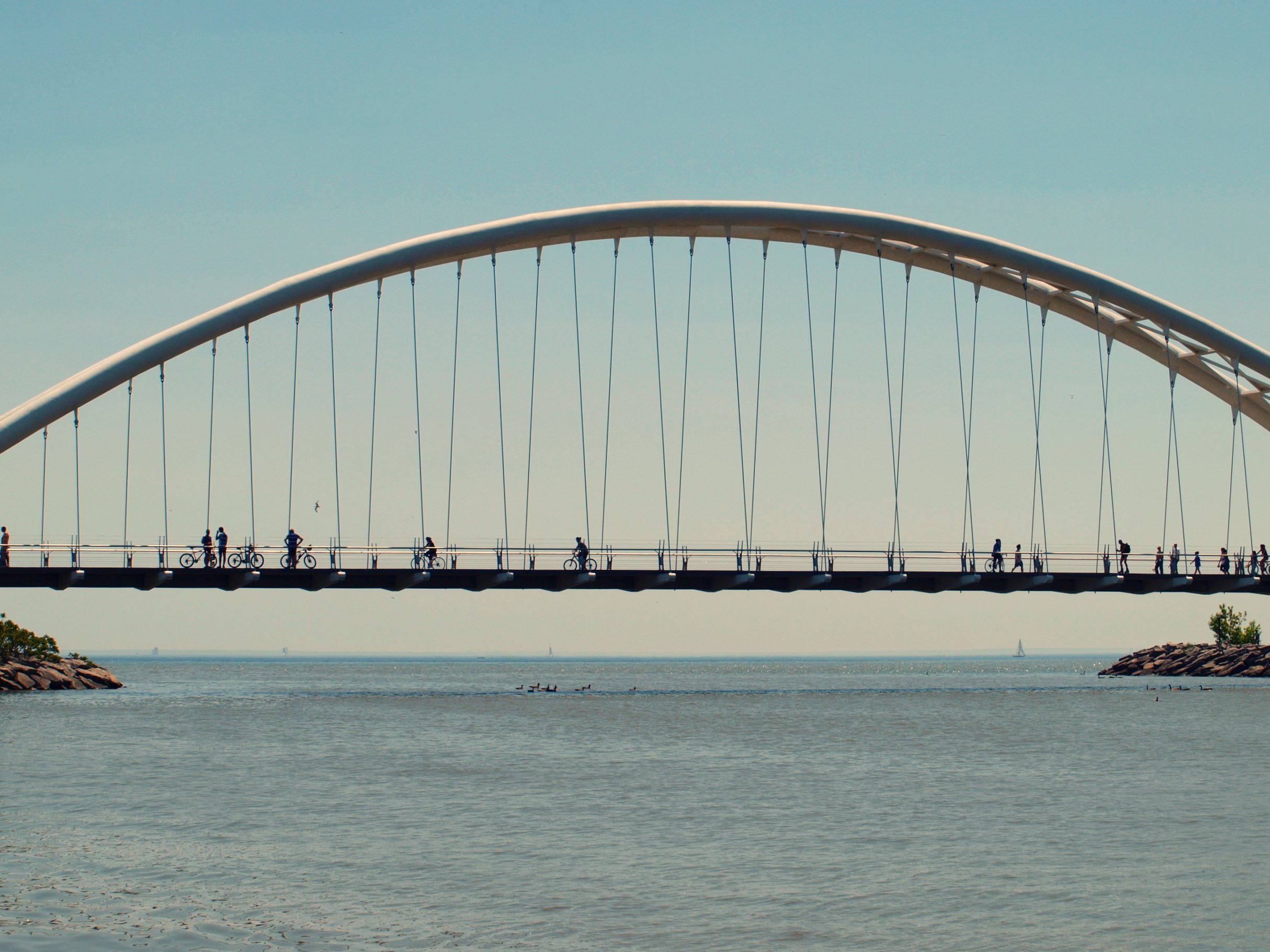
I quite enjoyed scootering along this bridge. There were amazing views from up there. About the Bridge: The Humber Bay Arch Bridge (also known as the Humber River Arch Bridge, the Humber River Pedestrian Bridge, or the Gateway Bridge) is a pedestrian and bicycle through arch bridge south of Lake Shore Boulevard West in Toronto, Canada. Completed in the mid-1990s, the bridge is 139 metres (456 ft) in length, with a clear span of 100 metres (330 ft) over the mouth of the Humber River to protect the environmental integrity of the waterway. The bridge is constructed of two 1,200 millimetres (47 in) diameter high-strength steel pipes, bent into twin arches that rise 21.3 metres (70 ft) above grade, and suspend the deck by way of 44 stainless-steel hangers, each 50 millimetres (2.0 in) in diameter. The foundation consists of concrete-filled caissons which go down 30 metres (98 ft) below grade to the bedrock. Designed in 1994 by Montgomery and Sisam Architects of Toronto and Delcan Corporation (bridge engineers), it was constructed by Sonterland Construction, and is the recipient of numerous local architectural, design and engineering awards. The bridge connects the former municipalities of "Old Toronto" and Etobicoke (both now part of the amalgamated City of Toronto) along an ancient aboriginal trading route along the shore of Lake Ontario, and thus features design elements and decorations such as carved turtles and canoes that evoke this native heritage. The bridge forms an important pedestrian and recreational link, and carries the Waterfront Trail, a multi-use pathway that will eventually parallel the entire north shore of Lake Ontario. The Toronto section is known as the Martin Goodman Trail, and is one of the most popular pedestrian and cycling routes in the city. en.wikipedia.org/wiki/Humber_Bay_Arch_Bridge |
| Date | Taken on 5 June 2011, 12:42 |
| Source | Humber Bay Arch Bridge |
| Author | Michael Gil from Toronto, ON, Canada |
| Camera location | | View this and other nearby images on: OpenStreetMap |
|---|
Licensing[edit]
- You are free:
- to share – to copy, distribute and transmit the work
- to remix – to adapt the work
- Under the following conditions:
- attribution – You must give appropriate credit, provide a link to the license, and indicate if changes were made. You may do so in any reasonable manner, but not in any way that suggests the licensor endorses you or your use.
| This image was originally posted to Flickr by MSVG at https://www.flickr.com/photos/13907834@N00/5803051272. It was reviewed on 10 March 2014 by FlickreviewR and was confirmed to be licensed under the terms of the cc-by-2.0. |
File history
Click on a date/time to view the file as it appeared at that time.
| Date/Time | Thumbnail | Dimensions | User | Comment | |
|---|---|---|---|---|---|
| current | 05:50, 10 March 2014 | | 2,428 × 1,821 (504 KB) | Geo Swan (talk | contribs) | {{Information |Description=I quite enjoyed scootering along this bridge. There were amazing views from up there. About the Bridge: The Humber Bay Arch Bridge (also known as the Humber River Arch Bridge, the Humber River Pedestrian Bridge, or the Gat... |
You cannot overwrite this file.
File usage on Commons
The following 2 pages use this file:
.jpg&redirect=no)